Sold2022Yorkshire.- Greenwood (Christopher) Map of the County of York, made on the Basis of Triangles in theNO RESERVE Yorkshire.- Greenwood (Christopher) Map of the County of York, made on the Basis of Triangles in the County, determined by Lieut. Col. Wm. Mudge, county map in six sections, with calligraphSee Sold Price
Sold2023Map of Somerset County, New JerseyMap of Somerset County with inset of Somerville lower right, hand-colored lithograph by J. W. Otley and J. Keily, printed by Lloyd Van Derveer, Camden, NJ, 1850 Overall: 47-3/4"h x 40"w Sight: 44-3/4"See Sold Price
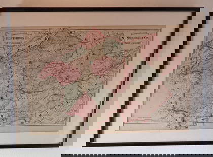
Sold2023Hearne Brothers Somerset County NJ MapPolyconic Projection map. Approx 50" x 65"See Sold Price
Sold2022Hamilton Farm James Cox Brady ResidenceHunterdon Somerset & Morris Counties Map is approx 33 1/2" x 43 1/2"See Sold Price
Sold2022Surrey.- Greenwood (C. & J.) Map of the County of Surrey from an actual Survey, made in the yearsNO RESERVE Surrey.- Greenwood (C. & J.) Map of the County of Surrey from an actual Survey, made in the years 1822 and 1823..., large county map, with vignette of Kew Palace, compass rose, calligraphicSee Sold Price
Sold2016Antique Map, County of Southampton, Greenwood & Co.Greenwood & Co. (British, 19th century), "Map of the county of Southampton from an Actual Survey, made in the years 1825 & 1826," hand-colored copper-engraved map, engraved by J. and J. Neele, publishSee Sold Price
Sold2019Christopher Greenwood (1786-1855) and John GreenwoodChristopher Greenwood (1786-1855) and John Greenwood (fl. 1821-1840) Map of the County of Essex, from an actual Survey made in the year 1824, by C & J Greenwood, 13, Regent St. Pall Mall, London, corrSee Sold Price
Sold2019Vintage Road Maps (14)Including 1980-1981 New Jersey map & guide; (3) Somerset & Hunterdon Counties New Jersey map; Burlington Bridges Area Road map; Northern Hunterdon County, NJ map; Sunoco New York map; Texaco Florida,See Sold Price
Sold2016Antique Map, County of Dorset from an Actual Survey,Greenwood & Co. (British, 19th century), "Map of the county of Dorset from an Actual Survey, made in the years 1825 & 1826," 1829, hand-colored copper-engraved map, engraved by H. Frost, published inSee Sold Price
Sold2022FRAMED MAP OF THE HAMILTON FARM, NEW JERSEY"Map of Hamilton Farm and Adjacent Properties, Bridle Paths, Roads, etc. in Hunterdon, Morris & Somerset Counties, in the State of New Jersey" by F.S. Tainter, March, 1935. Details include Somerset HiSee Sold Price
Sold2019Weller, Edward C1860 Lot of 7 UK County MapsIncl Northants, Worcester, Lancashire, Monmouth, Hereford, and Somerset. Lithograph Maps Published C1860, London for "The Dispatch Atlas" and/or "The Weekly Dispatch" by Edward Weller and others. InclSee Sold Price
Sold2024Dugdale & Archer C1840 Lot of 7 British County MapsIncl Oxford, Staffordshire, Somerset, Shropshire, Rutland, Nottinghamshire and Northumberland. Steel Engravinged Maps C1835-60 London for "Curiosities of Great Britain. England & Wales Delineated..."See Sold Price
Sold2018MAP OF NEW JERSEY COUNTIESOf Hamilton Farm, Hunterton, Morris, and Somerset Counties. Frame size: 27"h x 22 1/2"wSee Sold Price
Sold20231873 Illustrated Encyclopedia and Atlas Map of Madison County IllinoisBinding, cover and back worn and pages mixed condition. Includes Saline, Venice and Greenwood to name a few areas. Measures 18 x 15 x 2 inches.See Sold Price
Sold2023Antique English Map LotLot of antique maps, Hertfordshire, and Oxfordshire, England. Including Map of the County of Hertford, C & J. Greenwood 1834. With numerous other maps various sizes, 18th through 20th Centuries.See Sold Price
Sold2023"Counties of England" Book, Circa 1834"Atlas of the Counties of England" by C&J Greenwood, 1834, comprising partially colored surveys and maps, with folio binding. Provenance: Phyllis Lucas Gallery, NYC. [25 3/4" H x 17 1/4" W]. Cover disSee Sold Price
Sold2024John Speed 1610 Map County of CumberlandFramed, hand-colored copperplate engraved map on laid paper by John Speed (1551 or 1552 – 28 July 1629) entitled: "Cumberland and the Ancient Citie Carlile Described with Many Memorable AntiquitiesSee Sold Price
Sold2023An 1860 Map, Counties of New York, New Hampshire, Etc...Hand colored lithograph, by Samuel Augustus Mitchell (1790-1868). :County Map of the States of New York, New Hampshire, Vermont, Massachusetts, Rhode Island and Connecticut". Dimensions:15 1/2" x 23 1See Sold Price
Sold2023Antique Map County of Cumberland EnglandAntique Framed and Hand Colored Map of the County of Cumberland, England by Richard Blome (London Engraver 1600-1705) . 16 inches x 13 inchesSee Sold Price
Sold2023Antique Map County of Northumberland EnglandAntique Framed and Hand Colored Map of the County of Northumberland, England by Richard Blome (London Engraver 1600-1705) . 16 inches x 13 inchesSee Sold Price
Sold2021Moule, Thomas C1835 British Map. SomersetSteel Engraved Map Published C1835, London for "A Complete and Universal English Dictionary" by the Rev. James Barclay et al. Maps by Thomas Moule. Paper Size: 11 x 8.5 inch (28 x 22cm) Some toning prSee Sold Price
Sold2020Moule, Thomas C1850 British Map. SomersetSteel Engraved Map Published C1850 "A Complete and Universal English Dictionary" by the Rev. James Barclay et al. Maps by Thomas Moule. Paper Size: 10.5 x 8 inch (27 x 21cm) Good ConditionSee Sold Price
Jun 14DuMouchellesWilliam H. Gamble (American, B. 1863) Hand Colored Engraving, Ca. 1863, "County Map of Michigan AndUS$50(1 bid)
Jun 08Early American History Auctions1753 Map of the County of Lancaster Divided into its Hundreds, by Royal Mapmaker Emanuel BowenUS$280
Jun 08Early American History Auctions1720 Colonial Northumberland County Virginia Manuscript Deed and Map PlotUS$400
Jun 08Early American History Auctions1836 Hand-Colored Map, Country Twenty Five Miles Round The City Of New-York Published by D.S. StoneUS$260
59 mins LeftRapid Estate Liquidators and Auction GalleryFramed Collection Engravings & A Map From The Excursions In The County Of Sussex Published In 1822US$50


!["Counties of England" Book, Circa 1834: "Atlas of the Counties of England" by C&J Greenwood, 1834, comprising partially colored surveys and maps, with folio binding. Provenance: Phyllis Lucas Gallery, NYC. [25 3/4" H x 17 1/4" W]. Cover dis](https://p1.liveauctioneers.com/1221/310017/167287172_1_x.jpg?height=310&quality=70&version=1702345351)


