Sold2023Group of Gulf Road MapsApproximately 10 road mapps, all in fair to good conditionSee Sold Price
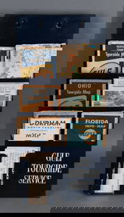
Sold2023Gulf Map and Tourgide Service w/Logo Metal Map Display (TAC)rated 8.5, 14"x18"x3.5", metal map display has very good color and shine, display panel is clean, has wear around the perimeter, comes with 10 Gulf road maps. TAC #046567See Sold Price
Sold20243-Circa 1930 Gulf Road Mapsrated 7 to 8, for New York, Georgia & Mid Atlantic states.See Sold Price
Sold2020Group of 18 : Antique/Vintage Service Station Road MapsCirca 1920s-40s,:Ê Includes Ohio, Kentucky, Sohio, Gulf, Amoco, and moreSee Sold Price
Sold2020Group of 30 Antique Service Station Road MapsCirca 1920s-30s, Includes Standard Oil, Sinclair, Shell, Gulf, Illinois, New York, Chicago, Alabama, and Many MoreSee Sold Price
Sold2024Gulf Tourgide Service & Request Card Metal Display Rackrated 8, 18"x9"x5", the metal map rack has good color, has light wear and fine scratches, comes with 10+ road maps.See Sold Price
Sold2017Group of 24 Vintage Road MapsFeaturing Chicago, Michigan, Sinclair, Gulf, Texaco, and MoreSee Sold Price
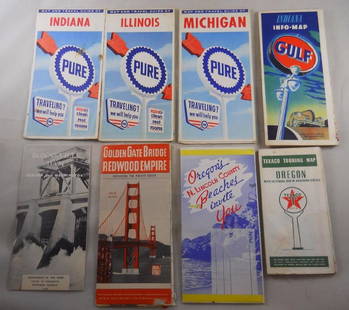
Sold2018Grouping of vintage gas station road maps and travelPure, Gulf, Texaco Maps. Golden Gate Bridge, N. Lincoln, Bonneville Dam – 8 pcs. Total.See Sold Price
Sold2024Group of 25 Shell and Pure Advertising Roadmaps8 Shell maps, 17 Pure travel tipsSee Sold Price
Sold2024Eight Gulf, Mobile & Ohio Railroad Playing Card Decks - Alton Route Map and LogoEight Gulf, Mobile & Ohio Railroad Playing Card Decks - Alton Route Map and LogoA group of eight playing card decks for Gulf, Mobile & Ohio Railroad almost completely unopened in original cellophane pSee Sold Price
Sold2024Small Collection of Electric Railway Ephemera - AERA Sign, Maps, Photographs, Books, and MoreSmall Collection of Electric Railway Ephemera - AERA Sign, Maps, Photographs, Books, and More A notable item among this small group of electric railway ephemera includes a 10" x 7 5/8" oval cardboardSee Sold Price
Sold2024Eleven Army Corps of Engineers Port Series No. 1 Through No. 8 Books with Fold Out MapsA group of Port Series books by the War Department US Army Corps of Engineers and Maritime Commission spanning 1928 to 1938, missing No. 4 in the series. Includes No. 1 Port of Portland Maine, No. 2 PSee Sold Price
Sold2022Gulf Tourgide Service road map display with maps & clipboard9" x 18" x 5"d Gulf road map display with maps & Gulf clipboard showing normal wear. *PLEASE NOTE, THERE IS ONLY ONE WAY TO PAY FOR ONLINE ITEMS IN THIS AUCTION WHICH IS THROUGH LIVE AUCTIONEERS. THISSee Sold Price
Sold20198 Various Road MapsLot contains Parco, 1931 Sinclair, early Monamotor, 1937 Red Indian, Sinclair, General Violet Ray, early Deep Rock, early Richfield, and 1953 Hancock. Great graphics maps that show good color with somSee Sold Price
Sold2020[BOSTON]. A group of 8 maps and directories for Boston[BOSTON]. A group of 8 maps and directories for Boston and Cambridge, comprising: DICKINSON, S. N. The Boston Almanac for the Year 1844. Boston: Thomas Groom & Co. -- DICKINSON. The Boston AlmanaSee Sold Price
Sold2023Group of 8 Road Champs and Super WheelsDie-cast vehicles. Majority model blazers. Original packaging , Largest packaging measures 6 x 4 1/4 inchesSee Sold Price
Sold2021Group of Road Maps & BrochuresGroup of 10 Vintage Travel Maps & Brochures See PhotosSee Sold Price
1 day LeftJasper521878 Mitchell Map of Washington, Oregon, Idaho, much of Montana [verso] Territory of IdahoUS$55
1 day LeftJasper521783 Bellin Map Tracing Explorers Marco Polo and Jenkinson and Showing Asia and Europe -- Carte pourUS$95
1 day LeftJasper521816 MAP NORTHERN PART OF RUSSIA or MUSCOVY in EUROPE copper engraving ANTIQUEUS$35
Featured1 day LeftJasper521866 Johnson's Map of Hungary, Austria, Greece and Turkey in Europe -- Johnson's Austria, Turkey inUS$60
1 day LeftJasper521764 Bellin Map of Northern Portion of Martinique -- Partie Septentrionale de la MartiniqueUS$45
1 day LeftJasper521764 Bellin Map of Eastern Guadeloupe in the Lesser Antilles -- Partie Orientale de l'Isle de laUS$80


![[BOSTON]. A group of 8 maps and directories for Boston: [BOSTON]. A group of 8 maps and directories for Boston and Cambridge, comprising: DICKINSON, S. N. The Boston Almanac for the Year 1844. Boston: Thomas Groom & Co. -- DICKINSON. The Boston Almana](https://p1.liveauctioneers.com/197/168691/85058461_1_x.jpg?height=310&quality=70&version=1589391499)


![1878 Mitchell Map of Washington, Oregon, Idaho, much of Montana [verso] Territory of Idaho (1 of 2)](https://p1.liveauctioneers.com/5584/329422/177662232_1_x.jpg?height=282&quality=70&version=1715717898)


![World Coins - Ostrogothic and Byzantine Coin Group [8] (1 of 1)](https://p1.liveauctioneers.com/1191/327727/176560248_1_x.jpg?height=282&quality=70&version=1714130530)
![Ancient Roman Imperial Coins - Mixed AR Antoninianus Group [8] (1 of 1)](https://p1.liveauctioneers.com/1191/327727/176559939_1_x.jpg?height=282&quality=70&version=1714130530)

![English Milled Coins - Silver Coin Group [8] (1 of 1)](https://p1.liveauctioneers.com/1191/327727/176560207_1_x.jpg?height=282&quality=70&version=1714130530)
![English Milled Coins - Charles II - AE Farthing Group [8] (1 of 1)](https://p1.liveauctioneers.com/1191/327727/176560179_1_x.jpg?height=282&quality=70&version=1714130530)
![Ancient Roman Imperial Coins - Mixed AR Antoninianus Group [8] (1 of 1)](https://p1.liveauctioneers.com/1191/327727/176560023_1_x.jpg?height=282&quality=70&version=1714130530)