Sold2021H. Moll C. 1730 Map of AsiaDESCRIPTION: H. Moll c. 1720 Map of Asia. Dedicated to the Right Honorable William, Lord Cowper, Lord High Chancellor of Great Britain. Hand colored, completed in three parts. MEASUREMENTS: 40 " wideSee Sold Price
Sold2022Scotland.- Ortelius (Abraham) Scotiae Tabula, engraved map, [c. 1603].Scotland.- Ortelius (Abraham) Scotiae Tabula, map of Scotland, oriented with north to the right, with large strap-work title cartouche in the upper right corner, sea monster and ship, engraving with hSee Sold Price
Sold2023Six Antique Maps of America Engravings, 19th c., H.- 7 1/4 in., W.- 4 1/2 in., Framed- H.- 15 in.,Six Antique Maps of America Engravings, 19th c., includes: "Map 8 1776 / Framing Declaration," "Map 5 1692 / New France: Map of the Discoveries of Marquette, La Salle and Other Frenchmen," "Map No. 12See Sold Price
Sold2023Antique 19th C. Map of East Los Angeles CountyAntique 19th Century panoramic map of East Los Angeles County, California, depicting a bird's-eye view from Los Angeles River looking towards the Sierra Madre Mountains. Printed by H.S. Crocker & Co.,See Sold Price
Sold2023Map of the United States of America, John Melish,Philadelphia, H. C. Corey & I. Lea, 1822, engraved by Benjamin Tanner, had colored from a complete historical, chronological and geographical American atlas. Sight size 17" x 22", in a high quality moSee Sold Price
Sold202418th C. Map of Arabia by Emanuel Bowman18th Century Map of Arabia, Turkey and Asia by Emanuel Bowman. Hand-colored engraving dated 1769 and framed behind plexiglass. Measurements: Map - 14"H x 17"W. Frame 21"H x 24"W. Condition report: GooSee Sold Price
Sold2022(5) ANTIQUE MAPS, MERCATOR & DE WITT, 17TH C.(lot of 5) Antique maps, early 17th c., published by Gerardus Mercator (Belgian, 1512-1594), likely from the "Mercator Hondius Atlas," published after his death c.1619, and Fredeick De Witt (Dutch, 16See Sold Price
Sold2020Abraham Ortelius Scotiae tabula, map of Scotland, 15thAbraham Ortelius Scotiae tabula, map of Scotland, 15th - 16th C., hand-colored engraving, plate size 14" x 18 3/4". Provenance: Estate of Mark W. Izard MD, Cider Brook Road, Avon, CT.See Sold Price
Sold2018JANSON, HONDIAS C. 1650 MAP OF NORTH AMERICAOriginal hand colored engraving with center fold. French text verso. Titled "America Septentrionalis." Famous map with California as an island. Dimensions: (Frame) H 26" x W 29", (Sight) H 19.25" x WSee Sold Price
Sold2018MATTHAUS SEUTTER (LUXEMBOURG C. 1730) MAPMap of fort and city of Luxembourg. Hand colored engraving. Dimensions: (Frame) H 20.75" x W 24.25", (Sight) H 19.75" x W 23" Condition: Foxing. Age toning.See Sold Price
Sold2023HERMAN MOLL (ENGLISH, C. 1654-1732) MAP OF NORTH AND SOUTH CAROLINAHERMAN MOLL (ENGLISH, C. 1654-1732) MAP OF NORTH AND SOUTH CAROLINA, hand-colored engraving on laid paper, titled "CAROLINA / By / H. Moll Geographer" in a rectangular cartouche along lSee Sold Price
Sold2018Early 20th c. mahogany map cabinet w/ 5 drawersMahogany map cabinet, early 20th century, of rectangular form with five wide drawers having brass cup pulls, the whole resting on a plinth base, 36"h x 55"w x 37.5"d. Top replaced.See Sold Price
Sold202318th C Antique Historical Map Of Montreal Quebec1758 Antique Historical Hand Tinted Map Of Montreal, Titled Plan of the Town and Fortifications of Montreal or Ville Marie in Canada. Map measures 7 inches H x 10 W within matting, framed 14.5 inchesSee Sold Price
Sold2020SPEEDE, JOHN, THE MAPE OF HUNGARISpeede, John THE MAPE OF HUNGARI [London] 1626 H. 39.5cm W. 51.3cm (sight) Engraved map, hand-coloured [Sold with]: Brion de la Tour, Louis Paris, [c. 1766] H. 38.5cm W. 53cm (sight) EngravedSee Sold Price
Sold2021Pictorial Map of Nantucket by Austin StrongHand colored in original and great condition, professionally matted and framed, c. 1921, 14 H inches x 17 W inches sight, 23 H inches x 26 W inches, overall. Austin Strong (1881-1952)Austin Strong, stSee Sold Price
Sold2021EARLY AMERICAN 3 DRAWER MAP CHEST, 19TH C.EARLY AMERICAN 3 DRAWER MAP CHEST HAVING GALLERY TOP RESTING ON TURNED FEET, 19TH C.;; 27.5"H X 31"W X 30"DSee Sold Price
Sold2024Willen Janszoon Blaeu, Scotia Regnum(Dutch, 1571-1638) Hand colored engraved map of Scotland, c. 1642. Framed double sided with book text on verso. Sight: 16-1/2"h x 21-1/4"w Overall: 26"h x 30-3/4"w Provenance: Paulus Swaen, Inc. IndiaSee Sold Price
Sold2021Rare set H.C. Tunison Wall MapsHeading: Author: Tunison, Henry Cuthbert Title: Tunison’s Twentieth Century Series of School Maps Place Published: Jacksonville, IL Publisher:H.C. Tunison, Publisher Date Published: c.1905See Sold Price
Sold2019Two Johann Baptist Homann (1661-1774) Maps, "VirginiaTwo Johann Baptist Homann (1661-1774) Maps, "Virginia Marylandia et Carolina in America Septatrionalis," c. 1720, hand colored, H.- 23 in., W.- 19 in. (2 Pcs.)See Sold Price
Sold2023GLASS-TOP COFFEE TABLE WITH ZODIAC & CELESTIAL MAPVintage coffee table, 20th c., glass top with astrological maps, signs of the zodiac, on brass pedestal support, approx 18"h, 40"w, 24.25"d Start Price: $300.00See Sold Price
Sold2018ROBERT MORRIS PORTFOLIO OF LITHOGRAPHS C. 1969ROBERT MORRIS, PORTFOLIO OF LITHOGRAPHS, C. 1969, 10 ITEMS H 30" W 22" "EARTH PROJECTSPORTFOLIO OF 10 LITHOGRAPHS ON GEOLOGICAL SURVEY MAPS. SIGNED AND NUMBERED 12 OF 125. COMMISSIONED BY SAM WAGSTAFFSee Sold Price
Sold2022CONTEMPORARY MIDWEST FARM LANDSCAPE O/C, SIGNEDBy Cecilia Price. Initialed "C" and dated 2000 lower right; signed C. Price, dated, and titled Memory Map on stretcher verso. Dimensions: H 32" x W 34" Condition: Small scuff to paint surface upper riSee Sold Price
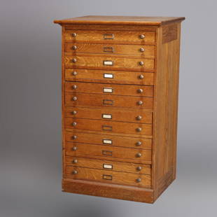
Sold2020Eight Drawer Oak Map, Art or Print File Cabinet, C 1910An antique map, art or print fining cabinet offers oak construction with eight drawers, brass pulls throughout, c1910. Measures- 45.5" H x 28" W x 22.75" D. ***IN-HOUSE SHIPPING & DELIVERY QUICK QUOTESee Sold Price
2 days LeftHolabird Western Americana CollectionsJourney to Mexico 2 Vols. 1826-34 & 1980 [181944]US$200
6 days LeftWinter Associates Three historical engraved maps of the Caribbean, ranging from 1616-1814, each hand colored, framedUS$100(1 bid)
Featured5 hrs LeftJasper521875, Brooklyn Bridge under Construction, Prospect Part, sites in the Holy Land. By HardestyUS$20
5 hrs LeftJasper52Scenes in Rome and the Vatican, Entrance to the Taj Mahal, temples in India and Thailand. ByUS$20
3 days LeftFreeman's | Hindman[HARDY, Thomas]. -- WINDLE, C.A. The Wessex of Thomas Hardy. Edmund H. New, illustrator. 1902.US$200
5 days LeftWorthington GalleriesFirst Edition Hand-colored Map THE NORTH RIDING OF YORKSHIRE by Robert MordenUS$50


![Scotland.- Ortelius (Abraham) Scotiae Tabula, engraved map, [c. 1603].: Scotland.- Ortelius (Abraham) Scotiae Tabula, map of Scotland, oriented with north to the right, with large strap-work title cartouche in the upper right corner, sea monster and ship, engraving with h](https://p1.liveauctioneers.com/5458/255060/132669296_1_x.jpg?height=310&quality=70&version=1657897192)


![SPEEDE, JOHN, THE MAPE OF HUNGARI: Speede, John THE MAPE OF HUNGARI [London] 1626 H. 39.5cm W. 51.3cm (sight) Engraved map, hand-coloured [Sold with]: Brion de la Tour, Louis Paris, [c. 1766] H. 38.5cm W. 53cm (sight) Engraved](https://p1.liveauctioneers.com/1124/176918/89050849_1_x.jpg?height=310&quality=70&version=1597790007)


![Journey to Mexico 2 Vols. 1826-34 & 1980 [181944] (1 of 11)](https://p1.liveauctioneers.com/2699/331494/178785478_1_x.jpg?height=282&quality=70&version=1717094654)


![[HARDY, Thomas]. -- WINDLE, C.A. The Wessex of Thomas Hardy. Edmund H. New, illustrator. 1902. (1 of 3)](https://p1.liveauctioneers.com/197/329395/177650387_1_x.jpg?height=282&quality=70&version=1715364962)
