Sold2017Hall: Map of Canada, Webster-Ashburton Treaty, 1943Map Title: 'British Possessions in North America, with part of the United States, compiled from official sources' Date: c1843 Size: Approx 38.0 x 64.5cm, 15 x 25.25 inches (Large) Type: Antique foldinSee Sold Price
Sold2023Webster-Ashburton Treaty 1842 Cast Border MarkerBorder Marker used in 1842 to resolve the logging disputes between the United States and Canada. Family lore is it was knocked down by a tree and later re purposed as a horse hitching post. MEAURES 72See Sold Price
Sold2022Bill of Exchange Signed by Lord Ashburton of Webster-Ashburton TreatyBill of Exchange Signed by Lord Ashburton of Webster-Ashburton Treaty [WEBSTER-ASHBURTON TREATY] Partially Printed Document Signed by British Diplomat Alexander Baring as “Ashburton”, 1p,See Sold Price
Sold2018Susan Hall (American, B. 1943) The Map of the Stars.Susan Hall (American, B. 1943) The Map of the Stars. Acrylic on canvas, unsigned. Provenance: Phyllis Kind Gallery, Chicago 47" x 33" Frame: 48" x 34.25"See Sold Price
Sold2019BRITISH NORTH AMERICA. Canada pre Oregon Treaty.TITLE/CONTENT OF MAP: 'BRITISH NORTH AMERICA' The map shows the border between the United States and British North America (now Canada) as it was before the Oregon Treaty of 1846, and it shows what isSee Sold Price
Sold2019Travels In N. America In1827-28, hand colored map, 1830Title: Travels In North America, In The Years 1827 And 1828 Provenance: IN THREE VOLUMES, 1830, with large hand colored folding map of United States and Canada showing Capt. Hall's route. [HOWES H 47]See Sold Price
Sold2022Large Antique French 1783 De L'Isle Map of the United States and CanadaImportant map of Guillaume de L'Isle corrected by Philippe Buache and edited by Dezauche in 1783 ,after the conclusion of the American revolutionary war and the treaty of Paris Dezauche updated the neSee Sold Price
Sold2021Francis Hall Travels in Canada and US 1818Travels in Canada and The United States, in 1816-1817 by Lieut. Francis Hall. 1818. Republished by Wells and Lilly, London. Lacking Map and pages 11-12. 332 pp. with browning and spotting. Measures 7.See Sold Price
Sold2019Canada, New Brunswick and Nova ScotiaReserve Reduced! Title: Canada, New Brunswick and Nova Scotia Publication Date: c1840 Cartographer: HALL, SIDNEY Publisher: LONGMAN, ORME & CO. Size (inches): 16.5Height - 20Width Map showing from HudSee Sold Price
Sold2022Vintage Map; 1943 Banff-Bassano Navigation chart used by members of the Royal Canadian Air Force inVintage Map; 1943 Banff-Bassano Navigation chart used by members of the Royal Canadian Air Force in the area of Calgary. Alberta. Canada.See Sold Price
Sold2022Carl Ray, Ontario / Canada (1943-1978), Spirit, acrylic on boardCarl RayOntario / Canada, (1943-1978)Spiritacrylic on boardsigned lower right, framed.23 1/2 x 30 inchesSee Sold Price
Sold2022Carl Ray, Ontario / Canada (1943-1978), Bird and Man, acrylic on boardCarl RayOntario / Canada, (1943-1978)Bird and Manacrylic on boardsigned lower right, framed.28 x 21 1/2 inchesSee Sold Price
Sold2022Carl Ray, Ontario / Canada (1943-1978), Northern Lights, 1974, acrylic on boardCarl RayOntario / Canada, (1943-1978)Northern Lights, 1974acrylic on boardsigned and dated lower right, framed.27 1/2 x 40 inchesSee Sold Price
Sold2024A scarce and very large plan of Montreal[MAP-CANADA] ADAMS, JOHN, surveyor. Map of the City and Suburbs of Montreal ... Constructed from a New Survey, 1825 by John Adams. New York: Engraved by J. D. Stout, 1825. Engraved map on three largeSee Sold Price
Sold2021Engraved Map of Canada, 18th c.18th century engraved map of Canada. Sheet 22.25" x 17.75". –See Sold Price
Sold202117th century map "Le Canada ou Nouvelle France", 17" x17th century map "Le Canada ou Nouvelle France", 17" x 23".See Sold Price
Sold2023Rare 1925 Map of The Town and Harbor of Nantucket by Phillip L. HallRare 1925 Map of The Town and Harbor of Nantucket by Phillip L. Hall, whimsical map showing the town, harbor, ships, aircraft, and prominent landmarks of the island. Overall 23 in. x 15 in.See Sold Price
Sold2023Five Antique Maps, North & South AmericaDescription: Five antique maps including a 1834 Charles Bowen mapof the Great American Eclipse, an unattributed 1825 map of New England, an 1834 Graf & Sorel map of Nunavut, Canada from the exploratioSee Sold Price
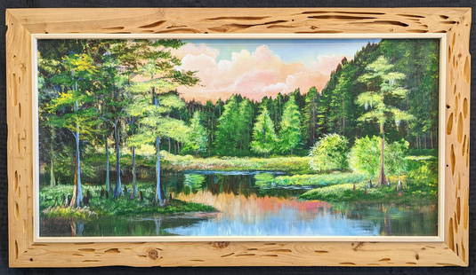
Sold2023Robert Butler 18x36 'Cypress Bend'Robert Butler (1943-2014) Florida Highwaymen, Florida Art Hall of Fame Artist. Oil painting 'Cypress Bend' on canvas. Backriver scene with cypress trees on the water, colorful clouds and great detail.See Sold Price
Sold2023Robert Butler 20x30 'Backcountry Cabin'Robert Butler (1943-2014) Florida Highwaymen, Florida Art Hall of Fame Artist. Oil painting 'Backcountry Cabin' on canvas. Backwoods scene with house, trailered boat, dirt roads and multiple highly-deSee Sold Price
1 day LeftAlbion AuctionsClarke & Russell 1814 Hand Col Map. Canada - British Dominions in North AmericaUS$25(3 bids)
1 day LeftAlbion AuctionsGlasgow Geography 1825 Antique Map. Canada - British Possessions in AmericaUS$5(1 bid)
May 30Forum Auctionsd'Anville (Jean Baptiste Bourguignon) [Untitled Composite Atlas with 102 map sheets], [probably£2,000
Jun 06Austin Auction Gallery(10) ART GLASS PAPERWEIGHTS, ROBERT HELD, ROBERT EICKHOLT, STEUBEN & OTHERSUS$100
6 days LeftJasper521892 Black Map of US New England to New York, Pennsylvania, New Jersey and Canadian Maritimes plusUS$85


![Bill of Exchange Signed by Lord Ashburton of Webster-Ashburton Treaty: Bill of Exchange Signed by Lord Ashburton of Webster-Ashburton Treaty [WEBSTER-ASHBURTON TREATY] Partially Printed Document Signed by British Diplomat Alexander Baring as “Ashburton”, 1p,](https://p1.liveauctioneers.com/6306/260874/135867934_1_x.jpg?height=310&quality=70&version=1662577413)


![Travels In N. America In1827-28, hand colored map, 1830: Title: Travels In North America, In The Years 1827 And 1828 Provenance: IN THREE VOLUMES, 1830, with large hand colored folding map of United States and Canada showing Capt. Hall's route. [HOWES H 47]](https://p1.liveauctioneers.com/5584/144949/73283335_1_x.jpg?height=310&quality=70&version=1561753751)


![A scarce and very large plan of Montreal: [MAP-CANADA] ADAMS, JOHN, surveyor. Map of the City and Suburbs of Montreal ... Constructed from a New Survey, 1825 by John Adams. New York: Engraved by J. D. Stout, 1825. Engraved map on three large](https://p1.liveauctioneers.com/292/326828/175962870_1_x.jpg?height=310&quality=70&version=1713473479)


![d'Anville (Jean Baptiste Bourguignon) [Untitled Composite Atlas with 102 map sheets], [probably (1 of 3)](https://p1.liveauctioneers.com/5458/329231/177514974_1_x.jpg?height=282&quality=70&version=1715269091)


![[LONDON] RELICS OF OLD LONDON. LOT OF 8 TOGETHER (1 of 9)](https://p1.liveauctioneers.com/8124/329546/177689815_1_x.jpg?height=282&quality=70&version=1715469494)
![[INDIGENOUS] WANAMAKER, ETC. LOT OF 4 TOGETHER (1 of 4)](https://p1.liveauctioneers.com/8124/329546/177689823_1_x.jpg?height=282&quality=70&version=1715617106)


![[STEREOS] TORONTO, ETC. LOT OF 8 SOLD TOGETHER (1 of 4)](https://p1.liveauctioneers.com/8124/329803/177770636_1_x.jpg?height=282&quality=70&version=1715634941)

![[BOOKS] CANADIAN PHOTOGRAPHY. LOT OF 6 VOLS (1 of 4)](https://p1.liveauctioneers.com/8124/329803/177770584_1_x.jpg?height=282&quality=70&version=1715634941)


