Sold20182 MAPS FRAMED, SCOTLAND OF OLD, IRELAND, BULLOCK MAPSTwo framed maps, Scotland of Old and Ireland. Windowbox style frames. 1969 Bullock Pictorial Historical Map of Ireland - This is a delightful 1969 L.G. Bullock pictorial historical map of Ireland. BulSee Sold Price
Sold2019Historical Map of ScotlandTitle: Historical Map of Scotland Publication Date: 1952 Cartographer: BULLOCK, L. G. Publisher: JOHN BARTHOLOMEW & SON Size: 36.5 X 24.25 Vividly colored maps showing historic sites surrounded by armSee Sold Price
Sold2016Map Orientation, France & Germany. Mallet.Fig. 75. Map Orientation, France and Germany. Description de l'Univers Maker: Mallet, Allain Manesson Origin: Frankfurt, Chez Jean David Zunner, 1685. Medium: Copperplate engraving. Sheet size: 7 3/4See Sold Price
Sold2024MAP, Germany, MunsterCentral Germany. Sebastian Munster, Francken Land in Germania..., from Cosmographei oder Beschreibung aller L?nder, 1556 (published). Hand Color. This woodblock map is oriented with north to the bottoSee Sold Price
Sold2021Guthrie, William 1806 Map. GermanyCopper Engraved Map Published 1806, London for "A New Geographical, Historical and Commercial Grammar..." by William Guthrie. The maps are by John Senex, Thomas Kitchin and others. Folds as issued. PaSee Sold Price
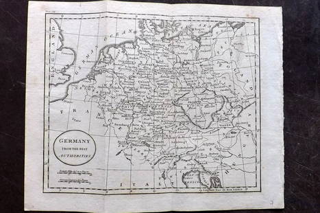
Sold2021Guthrie, William 1798 Map. GermanyCopper Engraved Map Published 1798, London for "A New Geographical, Historical and Commercial Grammar..." by William Guthrie. The maps are by John Senex, Thomas Kitchin and others. Folds as issued. PaSee Sold Price
Sold2021Guthrie, William 1798 Map. GermanyCopper Engraved Map Published 1798, London for "A New Geographical, Historical and Commercial Grammar..." by William Guthrie. The maps are by John Senex, Thomas Kitchin and others. Folds as issued. PaSee Sold Price
Sold2021Barlow 1807 Antique Map. GermanyCopper Engraved Map Published 1807 by Brightly & Kinnersley, Bungay, England for "A General View of the World, Geographical, Historical and Philosophical" by The Rev. E. Blomfield. Engraved by Barlow.See Sold Price
Sold2022Guthrie & Kitchin 1782 Map. GermanyCopper Engraved Map Published 1782, London for "A New Geographical, Historical and Commercial Grammar..." by William Guthrie. The maps are by John Senex, Thomas Kitchin and others. Folds as issued. PaSee Sold Price
Sold2022LUFTWAFFE FLIGHT MAP OF GERMANY, FRANCE AND ENGLANDDouble-sided ‘Luft-Navigationskarte’ (‘Air Navigation Map’), 26.5 x 24 in., printed on weatherproofed canvas and produced by the General Staff of the Luftwaffe, circa 1941. BSee Sold Price
Sold2023Guillaume de l'Isle Map of Germany and Western Europe.‘L'Allemagne, Dressee sur les Obfervations de Tycho-Brahe de Kepler de Snellius’, image 19 x 24.5 inches, engraved by Jean Baptiste Liebaux, c. 1720, hand tinted, framed, 29 x 34.5 incSee Sold Price
Sold2023Exquisite vertical format vintage map of Germany – 1865Beautiful and large two-page map of Germany in an unusual vertical format. Covers the region from the Baltic Sea to the Adriatic Sea. This historical document shows the two great regions of Germany, PSee Sold Price
Sold2022Middle East and Europe Historical Antique MapCarte de La Geographie Sacree Pour L'Ancien Testament. Pierre Moullart Sanson, Paris: 1716. Engraving, outline color. Center fold as issued. 21 1/4" x 28 1/2".See Sold Price
Sold2021Kitchin, Thomas 1785 Map of Germany & Netherlands"Germany with the Seven United Provinces" Copper Engraved Map Published 1783-85, London for "A New Geographical, Historical and Commercial Grammar..." by William Guthrie. Drawn and Engraved by ThomasSee Sold Price
Sold2019Mallet, Alain 1683 Map of Germany & Part of Poland"Allemagne en General" Copper Engraved Map Published 1683, Paris for "Description de l'Univers" by Alain Manesson Mallet. French text to verso. Paper Size: 8 x 5 inch (20 x 13cm) Good ConditionSee Sold Price
Sold2021Barlow 1807 Antique Map of GermanyCopper Engraved Map Published 1807 by Brightly & Kinnersley, Bungay, England for "A General View of the World, Geographical, Historical and Philosophical" by The Rev. E. Blomfield. Maps Engraved by BaSee Sold Price
Sold2022Lizars, Daniel 1831 LG Rare HC Map. Franconia, GermanyLarge Folio Copper Engraved Map Published 1831-2 by John Hamilton, Successor to Daniel Lizars, Edinburgh for "The Edinburgh Geographical and Historical Atlas..." First Edition by Daniel Lizars. Very fSee Sold Price
Sold2023Lizars, Daniel 1831 LG Rare HC Map. Franconia, GermanyLarge Folio Copper Engraved Map Published 1831-2 by John Hamilton, Successor to Daniel Lizars, Edinburgh for "The Edinburgh Geographical and Historical Atlas..." First Edition by Daniel Lizars. Very fSee Sold Price
Sold2019Delamarche, Felix 1829 Lot of 3 Maps. Europe & Germany"L'Europe a l'Epoque du demembrement de l'Empire de Charlemagne" "L'Europe avan l'Invasion des Barbares" and "Germania Antiqua et regiones Danubium" Copper Engraved Maps Published 1829, Paris for "AtlSee Sold Price
Sold2024Bing Tin Litho Anniversary Limited Edition Fire Engine TaggedBing Fire Ladder Tin Toy, Nurnberger. Historical 1925 tin toy using old tooling. Beautiful and shining fire toy from Germany. 8" L.See Sold Price
Sold2022Lizars, Daniel 1831 LG Rare HC Map. Upper Saxony, GermanyLarge Folio Copper Engraved Map Published 1831-2 by John Hamilton, Successor to Daniel Lizars, Edinburgh for "The Edinburgh Geographical and Historical Atlas..." First Edition by Daniel Lizars. Very fSee Sold Price
Sold2023Lizars, Daniel 1831 LG Rare HC Map. Upper Saxony, GermanyLarge Folio Copper Engraved Map Published 1831-2 by John Hamilton, Successor to Daniel Lizars, Edinburgh for "The Edinburgh Geographical and Historical Atlas..." First Edition by Daniel Lizars. Very fSee Sold Price
Sold20241937 A WWII Germany 1 pfennig. Historical symbol1937 A WWII Germany 1 pfennig. Historical symbolSee Sold Price
Sold2022e L'Isle Philippe Buache Engraved cooper map of Spain 1789Important map of Guillaume de L'Isle corrected by Philippe Buache and edited by Dezauche in 1800 ,this map is full of interesting historical fact , one is the state of the political situation just priSee Sold Price
Featured3 days LeftJasper521799 Cary Map of Hungary -- A New Map of Hungary, with Its Divisions into Gespanchafts or Counties;US$70
Oct 27Schilb Antiquarian Rare Books1764 OTTOMAN WARS Turkey Murad I Battle of Vienna MAP Hapsburgs Islam MuslimUS$36(4 bids)
4 days LeftFrost & NicklausJohann Philipp Schonborn, 1655 Engraved by Johann Friedrich FleischbergerUS$80
3 days LeftJasper52Large Antique French map GERMAN EMPIRE 1792 colored by POIRSON engraver BassetUS$170
4 days LeftJasper52Empire du Japon divisée en sept principales parties. Japan. DE VAUGONDY 1750 mapUS$260
3 days LeftJasper521799 Cary Map of Germany's Bavaria -- A New Map of the Circle of Bavaria, from the LatestUS$70
3 days LeftJasper52Rand, McNally & Co.'S Indexed Atlas of the World Map of Germany (Western Sheet). | (Eastern Sheet).US$60
3 days LeftJasper521799 Cary Map of Germany's Franconia -- A New Map of the Circle of Franconia, from the LatestUS$70
3 days LeftJasper521801 Cary Map of Germany's lower Saxony -- A New Map of the Circle of Lower Saxony From the LatestUS$70