Sold2018Holy Land.- Jansson (Jan) Judaeae seu Terrae Israelis,Holy Land.- Jansson (Jan) Judaeae seu Terrae Israelis, map showing the divided kingdoms of Judea and Israel, with large title cartouche supported by the figures of Moses and Aaron in the upper left coSee Sold Price
Sold2020(HOLY LAND.) Janssonius, Johannes. Judaeae seu Terrae(HOLY LAND.) Janssonius, Johannes. Judaeae seu Terrae Israelis Tabula Geographica. Double-page engraved map of the Holy Land with two decorative figural cartouche designs. 18¾x22¾ inches sheSee Sold Price
Sold2022MAP, Holy Land, JanssonHoly Land. Jan Jansson, Tabula Itineraria Patriarcharum Abrahami, Isaaci et Iacobi, from Accuratissima Orbis Antiqui Delineatio…, 1657 (published). Hand Color. A fine decorative map illustrating theSee Sold Price
Sold2022Holy Land.- Sanson (Guillaume) Iudaea, seu Terra Sancta quae Hebraeorum sive Israelitarum in suasNO RESERVE Holy Land.- Sanson (Guillaume) Iudaea, seu Terra Sancta quae Hebraeorum sive Israelitarum in suas Duodecim Tribus Divisa, map of the kingdoms of Judea and Israel with tribal divisions, engrSee Sold Price
Sold2017Jaillot: Antique Map of Judea or the Holy Land, 1709Map: Iudea seu Terra Sancta Cartographer: Jaillot Place & Date: Paris / 1709 Size: 25 1/2" x 18 1/4" Condition: outline color (map), full color (cartouches); light overall age toning, otherwise a beauSee Sold Price
Sold2018Harenburg / Homann Heirs: Palestine & Cyprus, 1744Palaestina seu Terra olim Sancta J.C. Harenburg's map of the Holy Land "divided into 12 tribes and extended by Kings David and Solomon," is both highly dramatic and scholarly (Harenburg, clearly had iSee Sold Price
Sold2021Terra Sancta Holy Land Map with the Borders of the 12Terra Sancta Holy Land Map with the Borders of the 12 Tribes of Israel, Nuremberg, 1707. Johann Baptista Homann (German, 1664-1724). Title: Iudaea seu Palaestina ob sacratissima Redemtoris vestigia hoSee Sold Price
Sold2019Homann's map of the Holy Land, 1707Heading: Author: Homann, Johann Baptiste Title: Iudaea seu Palaestina ob Sacratissima Redemtoris Vestigia Hodie Dicta Terra Sancta Prout Olim in Duodecim Tribus Divisa Separatis ab Invicem Regnis IudSee Sold Price
Sold2017[HOLY LAND]. La Terra Santa ed i luoghi illustratiGRAND, Abbé –EGRON, Adrien César. La Terra Santa ed i luoghi illustrati dagli apostoli; con vedute pittoresche secondo Turner, Harding ed altri celebri artisti. Napoli, Dallo stabilimento del GuttSee Sold Price
Sold2022(HOLY LAND.) Abraham Ortelius. Terra Sancta.(HOLY LAND.) Abraham Ortelius. Terra Sancta. Double-page engraved map of the Holy Land. 16x21¼ inches sheet size, wide margins, Latin text on verso; original hand-color in full; minor toning andSee Sold Price
Sold2019Jan Jansson. Greece mapJan Jansson. Hellas seu Graecia Sophiani, hand coloured engraved map of Greece, c. 1658, 375 x 510mm (visible)See Sold Price
Sold2022MAP, Japan & Korea, JanssonJapan & Korea. Jan Jansson, Nova et Accurata Iaponiae, Terrae Esonis, ac Insularum Adjacentium. Ex Novissima Detectione Descriptio, from Atlas Contractus, 1666 (circa). Hand Color. This superb folio mSee Sold Price
Sold2018Holy Land.- Palestine.- Ortelius (Abraham) PalestinaeHoly Land.- Palestine.- Ortelius (Abraham) Palestinae Sive Totius Terrae Promissionis Nova Descriptio Auctore Tilemanno Stella Sigenens, map of the Holy Land, based on Tilemanno Stella's map of 1557,See Sold Price
Sold2020ORTELIUS, ABRAHAM. Palestinae sive Totius TerraeORTELIUS, ABRAHAM. Palestinae sive Totius Terrae Promissionis Nova Descriptio. Double-page engraved map of the Holy Land. 17½x22¼ inches sheet size, wide margins, Latin text on verso; originSee Sold Price
Sold2016c. 1670 Engraved Holy Land + Mediterranean MapHistoric Maps c. 1670 Engraved Map of the Holy Land & Mediterranean Sea c. 1670, Historic Hand-Colored Engraved Map entitled: “Terra Sancta sive Promissionis olim Palestina recens delineata,” by FSee Sold Price
Sold2022Theodore Danckerts (Dutch, 1663-1727) - Holy Land Map Divided to Tribes, Etching, Amsterdam, CaTheodore Danckerts (Dutch, 1663-1727) - The Holy Land Map Divided to Tribes, Colored Etching, Amsterdam, Circa 1690. Title: Judaea sive Terra Sancta quae Israelitarum In Suas Duodecim Tribus DestincatSee Sold Price
Sold2020Jan Jansson Colored Map of Central & South AmericaJan Jansson (Johannes Janssonius; Dutch, 1588-1664). Framed antique etching print of South and Central America. Titled TERRA FIRMA ET NOVUM REGNUM GRANATENSE ET POPAYAN. Hand colored. Unknown printingSee Sold Price
Sold2017Homann: Map of the Promised Land, 1720Map: Iudea seu Palaestina ob sacratissima Redentoris vestigia hodie dicta Terra Sancta Cartographer: Johannes Baptista Homann Place & Date: Nurnberg / 1720 Size: 22 1/2" x 19 1/4" Condition: light broSee Sold Price
Sold20171842 Roberts's Sketches in the Holy Land1842 Roberts's Sketches in the Holy Land- Syria, Indumea, Arabia, Egypt, & Nubia (2 bound volumes), w/ lithos by Louis Haghe, London F G Moon, original gilt embossed red leather bindings, slightly scuSee Sold Price
Sold2021Manuscript Map of the Holy Land, early 18th Century[Manuscript map of the Holy Land] Pencil, ink, and watercolor on faux vellum with horizontal and vertical folding creases (8 segments) and no mounting guard; pencil grid visible in upper left and righSee Sold Price
Sold2020Middle East.- Roberts (David) The Holy Land, Syria,Middle East.- Roberts (David) The Holy Land, Syria, Idumea, Arabia, Egypt, & Nubia, 6 vol. in 3, 248 tinted lithograph plates (including titles) and 2 engraved maps, occasional light foxing, corner ofSee Sold Price
Sold2015Jansson (Jan) - [Atlas Novus: Germany],single vol. lacking title, 106 mostly regional maps of Germany and northern Europe, but also including a general map of Germany, and classical maps of both Germany and Scandinavia, and several city plSee Sold Price
Sold2018Holy Land Pottery Offering Vessel - Iron AgeAncient Near East, Holy Land, Iron Age II, ca. 800 to 500 BCE. A large hand-built terracotta offering vessel with two main components. First is an openwork conical pedestal with a slight concave baseSee Sold Price
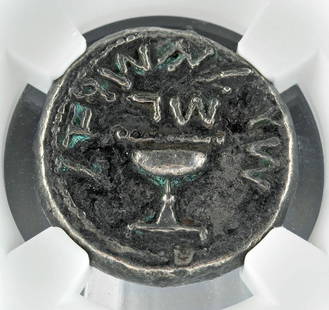
Sold2022Holy Land Judaea Jewish War AR Silver ShekelNear East / Holy Land, Judaea, Jewish War, ca. 66 to 70 CE. AR silver shekel. First revolt, year 3, 68-69 CE. 'Shekel of Israel' (Paleo-Hebrew), ritual chalice with pearled rim, the base raised by proSee Sold Price
2 days LeftTrillium Antique Prints & Rare BooksDe Jode, Rare, pub. 1593 - Map of the Holy Land (Descriptio Et Situs Terrae Sanctae Alio NomineUS$100(1 bid)
2 days LeftTrillium Antique Prints & Rare BooksPtolemy & Magini, pub. 1620 - 4 Maps of the Holy Land, Palestine, Persia, Turkey, EgyptUS$50
Jun 02Schilb Antiquarian Rare Books1871 Holy BIBLE & MAPS Holy Land Hitchcock Analysis Gruden Concordance TheologyUS$120(3 bids)
13 hrs LeftZikorn Arts & History ObjectsSteven Brooke, Signed 1st Edition: Views of Jerusalem & the Holy LandUS$50(1 bid)
Swann Auction GalleriesWomen in the Holy Land. Six Titles in Eight Volumes from the 19th Century.US$425
Swann Auction GalleriesWomen in the Holy Land. Five Titles in Seven Volumes from the 19th Century.US$425
2 days LeftAlbion AuctionsSale & Psalmanazar 1779 Map. Paradise Mount Ararat & Babel. Holy LandUS$10(2 bids)
Jun 23Schilb Antiquarian Rare Books1790 Life of Jesus Christ Fleetwood Bible ART Miracles Jerusalem MAP Holy LandUS$1
2 days LeftAlbion AuctionsMarmocchi, F. C. 1845 Hand Col Map. Holy Land. Persia Empire, Alexander the GreatUS$5
2 days LeftAlbion AuctionsMarmocchi, F. C. 1845 Hand Col Map. Holy Land. Canaan. Israel PalestineUS$5
6 days LeftPacific Global Auction20 gram Gold Bar - Holy Land Mint Dove of Peace (In Assay)US$1(1 bid)


![[HOLY LAND]. La Terra Santa ed i luoghi illustrati: GRAND, Abbé –EGRON, Adrien César. La Terra Santa ed i luoghi illustrati dagli apostoli; con vedute pittoresche secondo Turner, Harding ed altri celebri artisti. Napoli, Dallo stabilimento del Gutt](https://p1.liveauctioneers.com/3336/110291/57212490_1_x.jpg?height=310&quality=70&version=1511544421)


![Manuscript Map of the Holy Land, early 18th Century: [Manuscript map of the Holy Land] Pencil, ink, and watercolor on faux vellum with horizontal and vertical folding creases (8 segments) and no mounting guard; pencil grid visible in upper left and righ](https://p1.liveauctioneers.com/1968/225974/116712048_1_x.jpg?height=310&quality=70&version=1636655147)

![Jansson (Jan) - [Atlas Novus: Germany],: single vol. lacking title, 106 mostly regional maps of Germany and northern Europe, but also including a general map of Germany, and classical maps of both Germany and Scandinavia, and several city pl](https://p1.liveauctioneers.com/410/80717/41962763_1_x.jpg?height=310&quality=70&version=1445353131)