Sold2017Homann Heirs: Antique Map of Europe, 1746Map: Europe ** Nuremberg?? Date Printed: 1746 Cartographer: Homann Heirs Material/Medium: Paper Size: 21" x 23 1/4" Nuremberg. Hand colored copperplate engraved. Beautiful baroque style cartouche. PleSee Sold Price
Sold20181761 Insulae Islandiae, delineation, prout haec SolenniBy: Homann Heirs Date: 1761 (Published) Nuremberg Dimensions: 17.75 x 23.25 (45 cm x 59 cm) This rare and spectacular map of Iceland was published 1761 in Nuremberg by the Heirs of Homann. The map wasSee Sold Price
Sold2023Seutter - Map of North America including Great Lakes, Florida, Virginia, New England, Mexico, WestThis engraving is from a composite atlas presented by the Homann Heirs. Many of the maps in the collection were completed by J. B. Homann, Homann Erben, M. Seutter, and T. C. Lotter. The maps were oriSee Sold Price
Sold2017Harenburg/Homann Heirs: Holy Land, 12 Tribes, 1750Palaestina in XII tribus divisa. Homann's fascinating map of the Holy Land "divided into 12 tribes and it adjacent lands" was "revised and augmented by J.C. Harenburg" according to the French title trSee Sold Price
Sold2018Homann Heirs Map of Americas 1746 NuremburgHomann Heirs, framed America Mappa Generalis Secundum Legitimas Projectionis Stereographicae Regulas....Concinnata et Delineata ab Aug. Gott Boehmio, Phil Magistro. In Lucem Proferentibus HomannianisSee Sold Price
Sold2020Homann Heirs Map of the West Indies and Mexico 17Homann Heirs, "Mappa Geographica complectens I. Indiae Occidentalis Partem Mediam Circum Isthmum Panamensem," Nuremberg, 1740. Hand colored map of the Gulf Coast, Florida, and the Caribbean, with inseSee Sold Price
Sold2017Homann Heirs, map England and WalesHomann Heirs, map England and Wales, Homann Heirs (18th c.), "Regni Angliae et Principatus Cambriae Tabula Nova", c. 1793, 24.25"h x 20.5"w (sheet), unframed Provenance: Property from a major corporatSee Sold Price
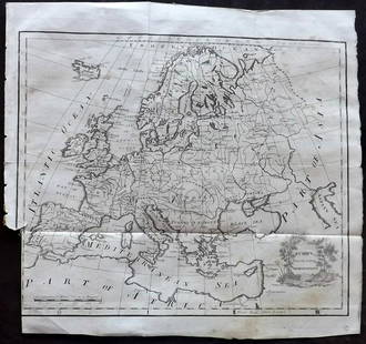
Sold2021Lochhead (Pub) 1811 Rare Map. EuropeCopper Engraved Map Published 1811 by William Lochhead, Berwick for "Modern Geography: And a Compendious General Gazetteer" Rare. Folds as issued. Paper Size: 12 x 10.5 inch (30 x 27cm) Some tone spotSee Sold Price
Sold2020Grp: 7 Maps of Sicily and Sardinia ItalyGroup of seven maps of Sicily and Sardinia, Italy. Early 18th century Johann Homann (1664-1724) map "Regnorum Sicilia et Sardinia;" 18th century Homann Heirs map of Sicily "Regni & Insulae Siciliae TaSee Sold Price
Sold2017Homann: Map of Europe, 1743Map: 1743 Homann Map of Europe -- Europa Secundum Legitimas Projectionis Stereographicae Regulas et Juxta Recentissimas Observationes Aeque ac Relationes… Cartographer: J. Homann Year / Place: 1743See Sold Price
Sold2017Homann Heirs: Antique Map of Asia, 1746Map: Asia Date Printed: 1746 Cartographer: Homann Heirs Material/Medium: Paper Size: 23 3/4" x 21" Printed in Nuremberg. Hand colored copperplate engraved. Beautiful baroque style cartouche. Please noSee Sold Price
Sold20231743 Homann Map of Europe -- Europa Secundum Legitimas Projectionis Stereographicae Regulas et JuxtaTitle: 1743 Homann Map of Europe -- Europa Secundum Legitimas Projectionis Stereographicae Regulas et Juxta Recentissimas Observationes Aeque ac Relationes… Cartographer: J. Homann Year / Place: 174See Sold Price
Sold2020Johann Matthias Hase Homann Heirs World MapJohann Mathias Hase (1684-1742), "Planiglobii Terrestris Mappa Universalis: Utrumque Hemisphaerium Orient. et Occidentale Repraesentans," Nuremberg: Homann Heirs, 1746. Hand colored map of the world iSee Sold Price
Sold2017Homann Heirs: Antique Map of Corsica, 1732Map: Insulae Corsicae olim Cyrus dictae Cartographer: Homann Heirs Place & Date: Nuremberg / 1732 Size: 17" x 20 3/8" Condition: overall age toning, heavier along horizontal centerfold; some light watSee Sold Price
Sold2017Homann Heirs: Antique Map of British West Indies, 1740Map: Dominia Anglorum in praecipuis Insulis Americae Cartographer: Homann Heirs Place & Date: Nuremberg / 1740 Size: 22" x 19 1/4" Condition: outline color; overall age toning; repaired splits at centSee Sold Price
Sold2017Homann Heirs: Antique Map of North & South America 1746Title/Content of Map: Americae mappa generalis Date Printed: 1746 Cartographer: Homann Heirs Material/Medium: Paper Size: 23 1/2" x 21" Hand colored copperplate engraved. Published in Nuremberg. Map hSee Sold Price
Sold2022Extremely rare map of Europe by John Cooke, 1800Highly unusual circular format makes this extremely rare map even that much more special. From The Universal Atlas of John Cooke, published in 1802. Full original hand color. A clean, sound map that wSee Sold Price
Sold20241738 Homann Heirs / Hase Map of ChinaRegni Sinae Vel Sinae Propriae Mappa et Descriptio GeographicaSee Sold Price
Sold2020Johann Baptist Homann Rare Denmark MapA rare map by Johann Baptist Homann (1663-1724), of Denmark, Slesvig-Holstein and contiguous parts of Germany. Written in the top left corner reads, "Regni Daniae in quo lunt Ducatus Holsatia et SlesvSee Sold Price
Sold2018ORAN "HOMANN HEIRS 1732" MAPMap with view published by Homann Heirs Amsterdam. Hand colored engraving. Dimensions: (Frame) H 22" x W 25", (Sight) H 20.25" x W 23.25" Condition: Heavily toned. Center fold.See Sold Price
Sold2023Lizars, Daniel 1831 LG Rare HC Map. Europe on 2 SheetsLarge Folio Copper Engraved Map Published 1831-2 by John Hamilton, Successor to Daniel Lizars, Edinburgh for "The Edinburgh Geographical and Historical Atlas..." First Edition by Daniel Lizars. Very fSee Sold Price
Sold2017Vaugondy: Antique Map of Europe, 1750Map: L'europe Publication Date: 1750 Authors: ROBERT DE VAUGONDY, DIDIER Size: Miniature – 5.75 H x 5.80 W Inches Par le Sr. Robert de Vaugondy avec privilege du roi 1750. Page 55 of a series used iSee Sold Price
Sold2017Homann Heirs: Antique Map of France, Picardy, 1746Title/Content of Map: 1746 France. Regional Map of Picardy Date Printed: 1746 Cartographer: Homann Heirs Material/Medium: Paper Size: 25" x 20" Copperplate engraved. Hand colored. Published in NurembeSee Sold Price
Sold2018SDUK: Antique Map of Europe, 1845TITLE/CONTENT OF MAP: 'EUROPE; inset table of population by country' The map shows Lombardia-Venetia as part of the Austrian Empire, the independent Ionian Islands, and Turkish Crete DATE PRINTED: 184See Sold Price
5 days LeftCoronari AuctionsTwo handcoloured engraved maps: N. Visscher (1618-1709): 'Magnae Brittanniae' (1695) and Homann€120
7 days LeftTrillium Antique Prints & Rare BooksEdwards - Map of England & Europe with Beetles & BirdsUS$50
7 days LeftTrillium Antique Prints & Rare BooksChatelain - 4 Engravings related to Egypt & Barbary, AfricaUS$75
7 days LeftTrillium Antique Prints & Rare BooksChatelain - 3 Engravings related to Guinea & CongoUS$75
7 days LeftTrillium Antique Prints & Rare BooksMoore & Conder - Map of the East India Islands (Includes Philippines, Cambodia, China, Borneo,US$75
7 days LeftTrillium Antique Prints & Rare BooksMoore & Conder - Map of North America with Canada, California as a Peninsula, Great Lakes, FloridaUS$75