Sold2023James Cook Antiquated MapAntiquated framed and glazed map / 'agenera chart' depicting the voyages and discoveries of Captain James Cook height 28 in. x width 42 in. x depth 1.5 in. We happily provide seamless shippiSee Sold Price
Sold2024James Cook - Map / Chart Of The Island TahitiEngraved nautical map from the 1774 first French edition of the first map of New Zealand, illustrating Lieutenant James Cook's 1769 exploration of the passage between New Zealand's North and South islSee Sold Price
Sold2024James Cook - Map of Tahiti, the Society Islands, and the VicinityEngraved nautical map from the 1774 first French edition of the first map of New Zealand, illustrating Lieutenant James Cook's 1769 exploration of the passage between New Zealand's North and South islSee Sold Price
Sold2024James Cook - Map of the Friendly Isles - Tonga IslandsThis is a French edition of Cook’s map of the Friendly Isles (Tonga Islands), published circa 1785.Size: 26 cm x 42 cmSee Sold Price
Sold2024James Cook - Antique map Australia titled 'Gezigt van het Eil. Suffren'. Antique map of SuffrenAntique map Australia titled 'Gezigt van het Eil. Suffren'. Antique map of Suffren Island. Originates from 'Reizen Rondom de Waereld door James Cook (..)'. Artists and Engravers: Translated by J.D. PaSee Sold Price
Sold20241783 Captain James Cook Third Pacific Voyage Illustrated MAP Australia Rickman1783 Captain James Cook Third Pacific Voyage Illustrated MAP Australia Rickman “Remember, the greater the opportunity, the fewer are those who see it.” – James Cook James Cook was an 18th-ceSee Sold Price
Sold2021Antique Map of Captain James Cook's Voyages to theAntique map of Captain James Cook's voyages to the Pacific region. Captain Cook made numerous discoveries in the Pacific region during the late 1700's . Artists and mapmakers aboard the ship, includinSee Sold Price
Sold20191783 Captain James Cook Third Pacific Voyage Illustrate1783 Captain James Cook Third Pacific Voyage Illustrated MAP Australia Rickman “Remember, the greater the opportunity, the fewer are those who see it.” – James Cook James Cook was an 18th-centurSee Sold Price
Sold2024Original Jean Baptiste D'Anville Occidental ou du Nouveau Monde Hemisphere Framed Map1786. Antique map showing most of the western hemisphere known to the world on the eve of the first voyage of James Cook by Jean Baptiste Bourguignon D'Anville. minus the North-West coast of North AmeSee Sold Price
Sold2016James Cook, Carte Des Decouvertes Mer PacifiqueAn engraved map / chart of the Pacific Islands, Carte Des Decouvertes faites dans la Mer Pacifique, Commande par le Capitaine Cook, en 1774. Authored by Captain James Cook in 1774, with Nouvelle CaledSee Sold Price
Sold2024Map of New Zealand Print from 1772 RecordThorndon Fine Prints (Wellington, New Zealand) reprodcued this chart of the 1772 record of New Zealand, which was compiled by Lieutenant James Cook Commander of the Endeavor, using the running surveySee Sold Price
Sold2024Robert Benard - pitcairn map - 1774The Map of Pitcairn Island, by expedition of James Cook by French engraver Robert BenardSize 32,5 x 35,5See Sold Price
Sold2023Wright, Thomas 1852 Portrait Print. Captain James Cook, AustraliaSteel Engraved Map Published 1852-56, London for "The Universal Pronouncing Dictionary" by Thomas Wright. Paper Size: 10.5 x 7 inch (27 x 18cm) Margin toning and staining present. Image fineSee Sold Price
Sold2022Antique Map Print of Oceania - Map of Old Rus' - Avachy Bay - James CookMap of Old Rus'. Avachy Bay, marine. Nicol 1785 engraved marine map with inset of the harbor of St. Peter and Paul. The relief is shown by dashes with sounding depths. This fascinating folio engravingSee Sold Price
Sold2022Antique Map Print of Oceania - Map of Madeira & The Azores - 1870 - James CookOriginal Antique Decorative Map of Madeira & The Azores, Fullarton, C.1870 This fascinating folio engraving is from Captain James Cook & James King's "A Voyage to the Pacific Ocean, for making DiscoveSee Sold Price
Sold20241842 VOYAGES OF CAPTAIN JAMES COOK 2 VOLUMES antique ILLUSTRATEDThe Voyages of Captain James Cook London: William Smith, 1842 2 volumes Size 7 by 9 3/4" Additional engraved title in volume I, engraved frontispieces, double-page maps, in-text vignettes, etc. MinorSee Sold Price
Sold2015Two maps of the Sandwich Islandsincluding Charte von den Sandwich Inseln by James Cook (1728- 1779), published in Des Capitan Jacob Cook's dritte Entdeckungsreise, 1788, depicting Cook's route through the Sandwich Islands/Hawaii, wiSee Sold Price
Sold2017Cooks Voyages with maps by TallisHeading: Author: Cook, James Title: The Voyages of Captain James Cook Round the World Place Published: London & New York Publisher:James Tallis & Company Date Published: c.1860 DescripSee Sold Price
Sold2017[Illustrated - Voyages and Exploration] James Cook's[Illustrated - Voyages and Exploration] James Cook's Third Voyage & More, Group of Prints GROUP OF ENGRAVED ILLUSTRATIONS, INCLUDING MAPS, RELATED TO COOK'S VOYAGES.See Sold Price
Sold2018Antique Chart of the Island of Tahiti, 1775Title/Content of Map: Chart of the Island of Otaheite Date Printed: 1775 ca. Cartographer: Capt. James Cook R.N. Size (inches): 12.3x16.1 Large scale map of the Island of Tahiti, with detailed typograSee Sold Price
Sold2024Antique Map - Views on the coast of Asia. J. Webber del. Engraved after J. Webber and W. Bligh.Views on the coast of Asia. J. Webber del. (Engraved after J. Webber and W. Bligh. London, G. Nicol and T. Cadell, 1785). Author: Webber, John, 1751-1793; Bligh, William, 1754-1817; Cook, James, 1728-See Sold Price
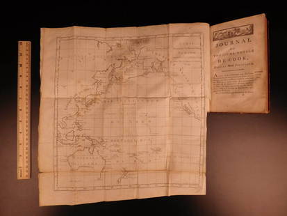
Sold2016Voyages.- Cook (Captain James), Troisieme Voyage deVoyages.- Cook (Capt. James) Troisieme Voyage de Cook, ou Voyage a l'Ocean Pacifique, 9 vol. (including Atlas), first French edition, 8 text vol. with half-titles, Atlas with 88 engraved maps and platSee Sold Price
Sold20241795-1803 JAMES COOK TRAVELS 13 VOLUMES ILLUSTRATED w/ 200 ENGRAVINGS antiqueREIZEN RONDOM DE WAERELD, door JAMES COOK, vertaald door J.D.PASTEUR (Translated by J.D. Pasteur) Leyden, Amsterdam and The Hague, Honkoop Allart and Van Cleef, 1795-1803 First edition in Dutch LanguaSee Sold Price
Sold20221774-1792 18 VOLUMES THREE VOYAGES of CAPTAIN JAMES COOK antiqueBeautiful copy, in luxury bindings, complete with the three voyages of Captain Cook in 18 octavo volumes. The first and the third voyage is first octavo edition, respectively from 1774 & 1785. The secSee Sold Price
3 days LeftJasper521796 VOYAGES of CAPTAIN COOK 3 vols 1st US EDITION ILLUSTRATED antique ENGLISHUS$1,000
157 Lots AwayTrillium Antique Prints & Rare BooksWebber & Cook, Rare - A Sailing Canoe of OtahaiteUS$500
156 Lots AwayTrillium Antique Prints & Rare BooksWebber & Cook, Rare - View of the Harbour of Taloo, in the Islands of EimeoUS$500
155 Lots AwayTrillium Antique Prints & Rare BooksWebber & Cook, Rare - A Toopapaoo of a Chief, with a Priest Making His Offering to the Morai, inUS$500
Jun 07Freeman's | HindmanCOOK, James, Captain. -- [SECOND VOYAGE]. A Voyage towards the South Pole, and Round the World...US$1,500
Jun 02Schilb Antiquarian Rare Books1880 Captain James Cook Voyages Hawaii Pacific Australia Kippis South Sea NavyUS$1(1 bid)
6 days LeftGolden Air Auctionsautographed/signed james cook buffalo red football jersey beckett BAS COAUS$170
4 days LeftGolden Air Auctionsframed autographed/signed james cook 33x42 buffalo red football jersey BAS COAUS$590
May 20Mynt Auctions1938 Calcutta India Experimental Rocket Flight cover Alipore James Cook CarriedUS$790
May 30Forum AuctionsMurder broadside.- bookbinder.- Dreadful Murder at Leicester. Particulars of a horrid Murder£300
3 days LeftJasper521817 3 VOYAGES of CAPTAIN COOK 6 vols ILLUSTRATED w/ WORLD MAP antique in FRENCHUS$1,000
5 days LeftPotter & Potter AuctionsLISTER, James Wren (1897 – 1952). Avalon Town / Santa Catal...US$100(1 bid)
6 days LeftAlbion AuctionsPrichard & Walker 1844 Hand Colored Map. Ethnological Map of AsiaUS$15(2 bids)


![[Illustrated - Voyages and Exploration] James Cook's: [Illustrated - Voyages and Exploration] James Cook's Third Voyage & More, Group of Prints GROUP OF ENGRAVED ILLUSTRATIONS, INCLUDING MAPS, RELATED TO COOK'S VOYAGES.](https://p1.liveauctioneers.com/46/113409/58240910_1_x.jpg?height=310&quality=70&version=1512492316)


![COOK, James, Captain. -- [SECOND VOYAGE]. A Voyage towards the South Pole, and Round the World... (1 of 2)](https://p1.liveauctioneers.com/197/329395/177650491_1_x.jpg?height=282&quality=70&version=1715364962)


