Sold2018ANTIQUE HAND COLORED WORLD MAP WITH SCENIC CORNERS.ANTIQUE HAND COLORED WORLD MAP WITH SCENIC CORNERS ON EARLY LAID PAPER. IMAGE 22 3/4 X 19 1/4See Sold Price
Sold2016c. 1760s, Hand-Colored World Map, “Mappa Mondo”Historic Maps 1760 Hand-Colored World Map, Siena Presso Pazzini Carli c. 1760s, Hand-Colored World Map, “Mappa Mondo,” Printed & Colored by Siena Presso Pazzini Carli, Choice Very Fine. A fine GobSee Sold Price
Sold2020Illustrated Van Loon Hand-Colored World Map, 1932Hendrik Willem Van Loon (Dutch-American, 1882-1944). Illustrated World Map, 1932. A hand colored outlined pictorial map of the world on Mercator projections with topographical relief shown pictoriallySee Sold Price
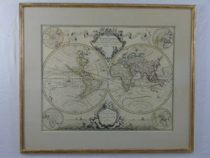
Sold2017Hand Colored World Map, FramedHand Colored World Map, Framed. Overall Dimensions: 30 x 33 in. This item is framed behind glass. Late 20th Century.See Sold Price
Sold2017After Van Geelkercken, Orbis Terrarum MapAfter Nicholas (Nicolaes) van Geelkercken (Netherlandish, circa 1585-1656), "Orbis Terrarum Descriptio Duobis Planis Hemisphaeriis Comprehesa", hand colored world map on paper. Hand colored engravingSee Sold Price
Sold2024Prichard & Walker 1844 Hand Colored Map. Ethnological Map of AsiaHand Colored Steel Engraved Map Published 1844, London for "Researches Into The Physical History Of Mankind" by James Cowles Prichard. Engraved by J & C Walker. Folds as issued. Paper Size: 16.5 x 14See Sold Price
Sold2015Two Hand-Colored Old World MapsTwo Hand-Colored Old World Maps of England/Wales and the Americas, consisting of "Accuratissima Angliae Regni et Walliae Principatus...", engraved by Cornelis Danckerts, ca. 1690-1700, plate 20-1/2" xSee Sold Price
Sold2024Coronelli's elegant two-sheet hemispheric world map[MAP - WORLD] CORONELLI, VINCENZO MARIA. Planisfero Del Mondo Vecchio; [and] Planisfero Del Mondo Nuovo. [Venice: circa 1691]. Two hand-colored engraved hemispheric world maps printed on separate sheeSee Sold Price
Sold2018World Map - Hand-Colored Engraving - England, 17thA Mapp or Generall Carte of the World Designed in two Plaine Hemisphers, by Monsieur Sanson Geographr to the French King and Rendered into English and Illustrated with Figures by Richard Blome By theSee Sold Price
2022Blaeu, Johannes (Netherlands, 1596-1673) "The New World Map" Double Hemisphere World Map C. 1664Nova et Accuratissima Totius Terrarum Orbis Tabula Translated "The New World Map", Hand Colored w/ Elaborately Decorated Spandrels.   Sight View 16" x 21-1/2", Overall View 21" x 25-1/2"See Sold Price
Sold2018Zurner: Antique Map of the World, 1700Title/Content of Map: World Map by Zurner Date Printed: c1700 Cartographer: A.F. Zurner Material/Medium: Paper Size: 20" x 21" Rare world Map. Hand colored engraved. Please note that this lot has a coSee Sold Price
Sold2019Double hemisphere world map by Ruscelli, 1561Heading: Author: Ruscelli, Girolamo Title: Orbis Descriptio Place Published: Venice Publisher: Date Published: 1561-[1574?] Description: Double-hemisphere copper-engraved wSee Sold Price
Sold20231855 Colton Handcolored Map, Southern Italy Kingdom of NaplesSouthern Italy Kingdom of Naples Sardinia & Malta, dated 1855, beautifully engraved, pastel colored map of Southern Italy &identifies various cities, towns, rivers, rapids, mountain passes, and an assSee Sold Price
Sold2020A General Map of the World.A General Map of the World. Hand-colored engraving on four joined sheets, published by Laurie & Whittle, London, 1794 Overall: 40.75" x 48.25" Frame: 48.5" x 55.5"See Sold Price
Sold2022Marvelous pictorial map of the WorldHeading: (Maps) Author: Ensign & Thayer Title: World at One View Place Published: New York Publisher: Date Published: 1847 Description: Lithographed double-hemisphere map of theSee Sold Price
Sold2018CHARLES SMITH (ENGLISH, 1768-1854) MAP OF THE WORLDCHARLES SMITH (ENGLISH, 1768-1854) MAP OF THE WORLD, hand-colored, depicting the Western and Eastern hemispheres, title centered above "The / WORLD / Engraved for Smith's Atlas", and centered below "PSee Sold Price
Sold2021COLTONS MAP OF THE WORLD ON MERCATORSPocket map of the world, hand colored, prepared for Henry Bill 1861, having a grape leaf & vine border, 19 1/4 x 27 inches, in display frame, 22 x 28 inchesSee Sold Price
Sold2018Hand Colored Map of the World, Willem BlaeuWillem Blaeu, (Dutch, 1571-1638) "Nova Totius Terrarum Orbis Geograhica ac Hydrographica" originally published 1606 Nice old color example of Blaeu's classic world map Approx. 19.5" x 25.5" (unframed)See Sold Price
Sold2020Framed Hand Colored Map of The World 19th CenturyFramed Hand Colored Map of The World 19th Century. Original Map of World Hemispheres with supposed population and religious division. Certificate of Authenticity on back.Condition: Very Good, slight wSee Sold Price
Sold202238 hand-colored maps of the world, c. 1815Heading: Author: [Gilling, W.] Title: A New General Atlas of the World with the Latest Discoveries and New Continental Alterations Place Published: London Publisher:W. Gilling Date Published: </See Sold Price
Sold2019Herman Moll 1654-1732), "A New And Correct Map of theHerman Moll 1654-1732), "A New And Correct Map of the World," 1710, hand colored, H. - 22 in., W. - 38 in.See Sold Price
Sold2016Large Framed World Map w/ Latin InscriptionsLarge Framed World Map w/ Latin Inscriptions. Hand colored. Professionally framed and matted. Titled Mappe Monde. Measures 28 by 33 inches.See Sold Price
Sold2020Johann Matthias Hase Homann Heirs World MapJohann Mathias Hase (1684-1742), "Planiglobii Terrestris Mappa Universalis: Utrumque Hemisphaerium Orient. et Occidentale Repraesentans," Nuremberg: Homann Heirs, 1746. Hand colored map of the world iSee Sold Price
Sold20211765 Map of the Hemispheres1765 Mape-Monde representee en Hemispheres Oriental et occidental Per Mr l'Abbe, Paris, hand colored map of the world, sight 4 1/2" x 6 1/2", well framed, overall size 14 1/4" x 16 1/4"See Sold Price
Jun 09Worthington Galleries18th c. Map OBSERVATIONS SUR LES POINTS CARDINAUX. LIGNES, ET CIRCLES DE LA SPHÈUS$10
Jun 09Worthington GalleriesAntique Hand-colored Hemisphere Map Mappemonde Revue par E. Cortambert 1864US$25
5 days LeftTrillium Antique Prints & Rare BooksKohler & Weigel - Map of the World with North and South Pole viewsUS$75(1 bid)
Featured2 days LeftJasper52c1720 World showing Dutch East India Co possessions. CA as a island. By J.MalherbeUS$600
Jun 18DOYLE Auctioneers & AppraisersA block puzzle with maps of Europe, England, Ireland, Scotland, America and the WorldUS$100
5 days LeftTrillium Antique Prints & Rare BooksBraun & Hogenberg, pub. 1575 - View of Delft, NetherlandsUS$100
5 days LeftTrillium Antique Prints & Rare BooksBraun & Hogenberg, pub. 1575 - Views in the Middle East: Aden, Mombasa, Kilwa, & SofalaUS$100(1 bid)
5 days LeftTrillium Antique Prints & Rare BooksBraun & Hogenberg, pub. 1575 - View of Ostia, ItalyUS$100
5 days LeftTrillium Antique Prints & Rare BooksBraun & Hogenberg, pub. 1575 - View of Alexandria, EgyptUS$100(1 bid)
5 days LeftTrillium Antique Prints & Rare BooksBraun & Hogenberg, pub. 1575 - View of Lyon, FranceUS$100
5 days LeftTrillium Antique Prints & Rare BooksBraun & Hogenberg, pub. 1575 - View of Chester, EnglandUS$100
Jun 09Worthington GalleriesFirst Edition Hand-colored Map THE NORTH RIDING OF YORKSHIRE by Robert MordenUS$50
Jun 08Early American History Auctions1836 Hand-Colored Map, Country Twenty Five Miles Round The City Of New-York Published by D.S. StoneUS$260


![Coronelli's elegant two-sheet hemispheric world map: [MAP - WORLD] CORONELLI, VINCENZO MARIA. Planisfero Del Mondo Vecchio; [and] Planisfero Del Mondo Nuovo. [Venice: circa 1691]. Two hand-colored engraved hemispheric world maps printed on separate shee](https://p1.liveauctioneers.com/292/326828/175962847_1_x.jpg?height=310&quality=70&version=1713473479)


![Double hemisphere world map by Ruscelli, 1561: Heading: Author: Ruscelli, Girolamo Title: Orbis Descriptio Place Published: Venice Publisher: Date Published: 1561-[1574?] Description: Double-hemisphere copper-engraved w](https://p1.liveauctioneers.com/642/139321/70635504_1_x.jpg?height=310&quality=70&version=1554323736)


![38 hand-colored maps of the world, c. 1815: Heading: Author: [Gilling, W.] Title: A New General Atlas of the World with the Latest Discoveries and New Continental Alterations Place Published: London Publisher:W. Gilling Date Published: </](https://p1.liveauctioneers.com/642/236542/122557359_1_x.jpg?height=310&quality=70&version=1644354597)