Sold2023Johnson & Exley 1812 Antique Map. AsiaCopper Engraved Map Published 1812, London for "The Imperial Encyclopaedia; Or, Dictionary of the Sciences and Arts" by William Moore Johnson & Thomas Exley. Paper Size: 10.5 x 8.5 inch (27 x 22cm)See Sold Price
Sold2023Johnson & Exley 1812 Antique Map. North AmericaCopper Engraved Map Published 1812, London for "The Imperial Encyclopaedia; Or, Dictionary of the Sciences and Arts" by William Moore Johnson & Thomas Exley. Paper Size: 10.5 x 8.5 inch (27 x 22cm) WaSee Sold Price
Sold2024Johnson & Exley 1812 Antique Map. AfricaCopper Engraved Map Published 1812, London for "The Imperial Encyclopaedia; Or, Dictionary of the Sciences and Arts" by William Moore Johnson & Thomas Exley. Paper Size: 10.5 x 8.5 inch (27 x 22cm) WaSee Sold Price
Sold2023Johnson & Exley 1812 Antique Map. England & WalesCopper Engraved Map Published 1812, London for "The Imperial Encyclopaedia; Or, Dictionary of the Sciences and Arts" by William Moore Johnson & Thomas Exley. Paper Size: 10.5 x 8.5 inch (27 x 22cm) WaSee Sold Price
Sold2023Johnson & Exley 1812 Antique Map. GermanyCopper Engraved Map Published 1812, London for "The Imperial Encyclopaedia; Or, Dictionary of the Sciences and Arts" by William Moore Johnson & Thomas Exley. Paper Size: 10.5 x 8.5 inch (27 x 22cm) WaSee Sold Price
Sold2023Johnson & Exley 1812 Antique Map. EuropeCopper Engraved Map Published 1812, London for "The Imperial Encyclopaedia; Or, Dictionary of the Sciences and Arts" by William Moore Johnson & Thomas Exley. Paper Size: 10.5 x 8.5 inch (27 x 22cm) WaSee Sold Price
Sold2023Johnson & Exley 1812 Antique Folio Map. World HemispheresCopper Engraved Map Published 1812, London for "The Imperial Encyclopaedia; Or, Dictionary of the Sciences and Arts" by William Moore Johnson & Thomas Exley. Paper Size: 17 x 10.5 inch (43 x 27cm) WatSee Sold Price
Sold2023Johnson & Exley 1812 Antique Print. Boa Constrictor, SnakesCopper Plate Pulished 1812, London for "The Imperial Encyclopaedia; Or, Dictionary of the Sciences and Arts" by William Moore Johnson & Thomas Exley. Paper Size: 10.5 x 8.5 inch (27 x 22cm) Good CondiSee Sold Price
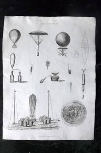
Sold2023Johnson & Exley 1812 Antique Print. Aerostation BalloonCopper Plate Pulished 1812, London for "The Imperial Encyclopaedia; Or, Dictionary of the Sciences and Arts" by William Moore Johnson & Thomas Exley. Paper Size: 10.5 x 8.5 inch (27 x 22cm) Good CondiSee Sold Price
Sold2017Johnson: Antique Map of Asia, 1864Map: 1864 Johnson Map of Asia -- Johnson's Asia Date Printed: 1864, New York Cartographer: Johnson & Ward Size: 12.5 x 15.5 in. Condition: Good overall. A 1.5 in. split (likely caused by a finger) thaSee Sold Price
Sold2017Johnson: Antique Map of Asia, 1863Map: 1863 Johnson Map of Asia -- Johnson's Asia Cartographer: Johnson & Ward Year / Place: 1863, New York Dimensions: 12.5 x 15.5 in. Condition: Very Good. Virtually no toning. A chip in lower right iSee Sold Price
Sold2017Johnson: Antique Map of Asia, 1863Map: 1863 Johnson Map of Asia -- Johnson's Asia Date Printed: 1863, New York Cartographer: A Johnson Size: 12.5 x 15.5 in. Condition: Very Good. Slight age toning, Slight marginal foxing, very slightSee Sold Price
Sold20201812 ANTIQUE MAP, SE ASIA for DR ROBERTSON HISTORICAL1812 ANTIQUE MAP, SE ASIA for DR ROBERTSON HISTORICAL DISQUISITION BOOK, PTOLEMY 1812 ANTIQUE MAP, SE ASIA for DR ROBERTSON HISTORICAL DISQUISITION BOOK, PTOLEMY Early Antique "Map of the SOUTH EAST pSee Sold Price
Sold2023Johnson & Exley 1812 Pair of Antique Fish PrintsCopper Plate Pulished 1812, London for "The Imperial Encyclopaedia; Or, Dictionary of the Sciences and Arts" by William Moore Johnson & Thomas Exley. Paper Size: 10.5 x 8.5 inch (27 x 22cm) Good CondiSee Sold Price
Sold2017Johnson: Antique Map of Turkey in Asia, 1868Map: Johnson's Turkey in Asia Date Printed: 1868 Material/Medium: Paper Size: 17" x 11 1/4" Condition: Excellent Hand colored. Copperplate engraved. Published in New York. Illustrated Family Atlas ofSee Sold Price
Sold2023Johnson & Exley 1812 Lot of 3 Antique Ship PrintsCopper Plate Pulished 1812, London for "The Imperial Encyclopaedia; Or, Dictionary of the Sciences and Arts" by William Moore Johnson & Thomas Exley. Paper Size: 10.5 x 8.5 inch (27 x 22cm) A few smalSee Sold Price
Sold2023Johnson & Exley 1812 Lot of 4 Antique Mammal PrintsCopper Plate Pulished 1812, London for "The Imperial Encyclopaedia; Or, Dictionary of the Sciences and Arts" by William Moore Johnson & Thomas Exley. Paper Size: 10.5 x 8.5 inch (27 x 22cm) One with cSee Sold Price
Sold2017Antique Map of India, 1812Early 1812 Antique "Map of the SOUTH EAST part of ASIA for illustrating Dr. Robertson's Historical Disquisition &c."; as found and removed from the book, "An Historical Disquisition concerning the knoSee Sold Price
Sold2017Johnson: Antique Map of Middle East, 1864Title/Content of Map: 1864 Johnson Map of Middle East -- Johnson's Turkey in Asia Persia Arabia &c. Date Printed: 1864, New York Cartographer: Johnson & Ward Size: 12.1 x 16.2 in. Nice Middle EasternSee Sold Price
Sold2017Johnson: Four Antique Historical Maps of Europe, 1881Map: Europe Under the Romans (2nd Century). | Europe Under the Carlovingians (9th Century). | Europe Under Napoleon I. (1810-1812). | Map of The Languages of Europe. Publication Date: 1881 Authors: A.See Sold Price
Sold2017Johnson: Antique Map of Florida, 1864Map: 1864 Johnson Map of Florida -- Johnson's Florida Cartographer: A Johnson Year / Place: 1864, New York City Map Dimensions: 12 x 15.3 in. Condition: Very Good. Vivid colors. Slight age toning throSee Sold Price
Sold2022LAPIE ORIGINAL ANTIQUE MAP ASIA MINOR 1831L' ASIE MINEURE 1831 SIZE: 25.5 X 20 INCHES APPROX. UNFRAMEDSee Sold Price
Sold2017Johnson: Antique Map of New York City, 1866Title/Content of Map: 1866 Johnson Map of New York City -- Johnson's New York and Brooklyn Date Printed: 1866, New York Cartographer: A Johnson Size: 22.8 x 16.3 in Condition: Very good. Age toning noSee Sold Price
Sold2017Johnson: Antique Map Nebraska Dakota Idaho MontanaJohnson’s Nebraska, Dakota, Idaho and Montana, c1865. One of the earliest appearances of Wyoming on a map -- so early, it has not been added to the map title. Pre-dates Yellowstone. Wyoming is in aSee Sold Price
May 30NY Elizabeth ANTIQUE MAP-ILLUSTRATED FLORAL ILLUSTRATION 1761 NEW DICTIONARY OF TRADE AND COMMERCE R. ROTHUS$50
1 day LeftJasper52Europe from the best authorities by Richard Brookes 1812 old antique map chartUS$30
3 days LeftAlbion AuctionsPrichard & Walker 1844 Hand Colored Map. Ethnological Map of AsiaUS$15(2 bids)
Featured11 hrs LeftJasper52Mitchell’s Map of Asia showing travel routes London, India, China & Japan, 1860US$45
1 day LeftJasper52OTTOMAN EMPIRE in Europe & Asia. Greece. British Ionian Islands. SDUK 1844 mapUS$65
1 day LeftJasper52EUROPE at French revolution 1789 & at height of Napoleon's Power 1812 1848 mapUS$30
1 day LeftJasper52Johnson's Sweden, Norway & Denmark with Sleswick & Holstein. Schleswig 1866 mapUS$60
1 day LeftJasper52Johnson's Sweden, Norway & Denmark with Sleswick & Holstein. Schleswig 1865 mapUS$60