Sold2020Large Framed Map of London, 1861Depicts London from the South Side of the Thames, this was a fold-out supplement to the illustrated London News, February 9, 1861, Rob Loudon Sr. Folds, creases, water stains in areas. Overall size: 2See Sold Price
Sold2018Large Framed 1794 Map of America Laurie & Whittle1794, London New Map of America & The West India Islands. With detailed side maps of California, and Baffin & Hudson Bay. Published by Laurie and Whittle. Map measures approximately 43.5" L x 49.5" H,See Sold Price
Sold2017A. K. Johnston Map of Asia, 1861Title: 1861 A. K. Johnson Map of Asia Cartographer: A. K. Johnston Published: 1861 London, Edinburgh Measurements: 17 x 22 in. Asia. This large-scale map of Asia was produced by Geographer to the QueeSee Sold Price
Sold2022A RARE 18TH CENTURY MAHOGANY FRAMED LARGE TRIPLE FOLDING SCREEN DEPICTING A DETAILED MAP OF THE CITYA RARE 18TH CENTURY MAHOGANY FRAMED LARGE TRIPLE FOLDING SCREEN DEPICTING A DETAILED MAP OF THE CITY OF LONDON from a bound volume of the Cities of London and Westminster and Southwark and ten-mile raSee Sold Price
Sold2022Large Framed Map of the City of Worcesterhas some creasing but presents nicely in the frame - Frame 71" x 61" Please see photos and come to the 2 day preview for condition.See Sold Price
Sold2023ESTATE OF SEYMOUR STEIN: 3 LARGE FRAMED MAPS/PRINTS - NY, PEEKSILL, PHILADELPIA EXHIBITION, LARGESTESTATE OF SEYMOUR STEIN: 3 LARGE FRAMED MAPS/PRINTS - NY, PEEKSILL, PHILADELPIA EXHIBITION, LARGEST IS 40" X 41"See Sold Price
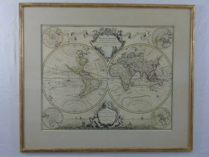
Sold2016Large Framed World Map w/ Latin InscriptionsLarge Framed World Map w/ Latin Inscriptions. Hand colored. Professionally framed and matted. Titled Mappe Monde. Measures 28 by 33 inches.See Sold Price
Sold2018LARGE MAP OF LONDON, 1843Drawn & Engraved From Authentic Documents & Personal Observations by B. R. Davies, London, published uner the Superintendence of the Society for the Diffusion of Useful Knowledge, by Charles Knight &See Sold Price
Sold2022FRAMED MAP OF LONDONSTILLIAR HANSA MAP OF LONDON. FRAMED UNDER GLASS. 27" x 21"See Sold Price
Sold2022Large Framed 1846 Map of FloridaLarge Framed 1846 Map of Florida; a reprint of the original, matted, glazed, and mounted in a wood frame. This map shows the state when central Florida was one large county aptly named Mosquito. All aSee Sold Price
Sold2020Bartholomew, John 1922 Large Map of LondonLarge Lithograph Map Published 1922 by The Times, London for "The Times Survey Atlas of the World" Maps by John George Bartholomew of the Edinburgh Geographical Institute. Centre fold as issued. PaperSee Sold Price
Sold2023Delaware and Hudson RR Framed Bridge Line Route Map 1823-1973This large framed poster/map is from the Delaware and Hudson Railroad and shows their routes for both canal and railroad from 1823 to 1973, between New England and Canada. An excellent, full color pieSee Sold Price
Sold2021Large Matted and Framed Map of Norfolk Virginia:Large Matted and Framed Map of Norfolk Virginia: Stylized Blazon Coat of Arms of Howard Duke of Norfolk (Premier Duke of England) Motto is "Virtuecont Alone is Invincible". Labeled JH DINGEE, Banker,See Sold Price
Sold2018Large 19th C. Framed Map of FloridaLarge 19th C. Framed Map of Florida. Image size: 26.5 inches.See Sold Price
Sold2021Large Hand Colored Framed Map of Italy, StanfordsLarge Hand Colored Framed Map of Italy, Stanfords. Dated 1859. Sight size: 4'8"h x 47-1/2"w Overall: 5'4"h x 4'7"w. Item cannot be unframed as it consists of multiple hand colored maps completing theSee Sold Price
Sold2022(LONDON.) George Philip & Son; The London Geographical Institute. Philips' New Library Map of London(LONDON.) George Philip & Son; The London Geographical Institute. Philips' New Library Map of London and Its Environs. Large chromolithographed map of London with postal divisions and district boundarSee Sold Price
Sold2020SOUTHERN STATES TRADE ROUTE MAPLarge Framed Trade Route Map showing waterways and towns from the Mississippi River to Charles Town. Geographic Area Covered: Southern States, South Carolina,Santee River Valley, Savannah River ValleySee Sold Price
Sold2022London.- Weller (Edward) London, lithographed map in nine sections, [c. 1863]; together with aNO RESERVE London.- Weller (Edward) London, large map in nine sections on a scale of 9 1/2" to the mile, lithograph, each sheet approx. 470 x 635 mm (18 1/2 x 25 in), edged with green silk and mountedSee Sold Price
Sold20231899 State of New York Framed Railroad Map - Colton Ohman & Co. PrinterLarge framed 1899 railroad map of the state of New York. This map was created by James B. Lyon to accompany the seventeenth annual report of the Board of Commissioners of the State of New York. The maSee Sold Price
Sold20191760 Folding Map of LondonCirca 1760 large folding map of London. Fine, measures 18.5 x 14.5”. Reserve: $40.00 Shipping: Domestic: Flat-rate of $5.00 to anywhere within the contiguous U.S. International: Foreign shipping ratSee Sold Price
Sold2024Baedeker, Karl 1905 Lot of 20 Antique Maps. LondonLithograph Maps Published 1895, Leipzig for "London und Umgebung" by Karl Baedeker. Folds as issued. Paper Size: Up to 27 x 6 inch (69 x 16cm) The Large London Map damaged. Good ConditionSee Sold Price
Sold2015Framed Johann Homann Map Of LondonA Prospect & Street plan of London by Johann Homann Nurnberg 1750, Wychwood Editions reproduction map. Frame: 28" x 32" Image: 21" x 25"See Sold Price
Sold2019Graf: Large South America Continent Map, 1861Cartographer: Geographisches Institut. / Graf Place/Date: Weimar / 1857/1861 Size: 17 3/4" x 22" Condition: wash color; light overall age toning and a minor stain on the right edge of the wide margin,See Sold Price
Sold2022Large Framed Johnson's Mercator's Projection Map of the World 40"x34" World MarketLarge Framed Johnson's Mercator's Projection Map of the World 40"x34" World MarketSee Sold Price
8 hrs LeftMynt AuctionsTerry Downes vs. Sixto Rodriquez 14x22 On Site 1961 Boxing Poster LondonUS$10(1 bid)
4 days LeftMynt Auctions1963 Henry Cooper v Cassius Clay (Ali) Program 6/18 Wembley Stadium London VG/ExUS$10
6 days LeftJasper52British Isles Railways companies regions. Ireland. GWR LMSR LNER. LARGE 1927 mapUS$60
6 days LeftJasper52Johnson's Prussia, Norway, Sweden & Denmark. Scandinavia Baltic Poland 1861 mapUS$85
6 days LeftJasper52Johnson's Roman Empire. Imperium Romanorum. Graecia Italia Greece Italy 1861 mapUS$160
May 30PropstorePINOCCHIO (1940) - Framed Limited Edition Pinocchio Oversized Hand-Painted Animation Cel Display, 19£1,000


![London.- Weller (Edward) London, lithographed map in nine sections, [c. 1863]; together with a: NO RESERVE London.- Weller (Edward) London, large map in nine sections on a scale of 9 1/2" to the mile, lithograph, each sheet approx. 470 x 635 mm (18 1/2 x 25 in), edged with green silk and mounted](https://p1.liveauctioneers.com/5458/259136/134937281_1_x.jpg?height=310&quality=70&version=1661338494)


![[CIVIL WAR] 7th PA Cavalry Colonel Portrait (1 of 2)](https://p1.liveauctioneers.com/7226/325455/175169073_1_x.jpg?height=282&quality=70&version=1712370394)


