Sold2022Scarce Texas map (eastern part) from Asher & Adams,County map of Eastern Texas extends from Louisiana west to beyond San Antonio and features the railroad system of that time. Features numerous railroads still in their infancy, along with proposed futSee Sold Price
Sold2018Spanish North America. THOMSON. Texas, Mexico &TITLE/CONTENT OF MAP: 'Spanish North America [northern part]' A large map of Texas, Mexico and the American Southwest, published in Edinburgh by John Thompson, based on the explorations of Humboldt anSee Sold Price
2024Spanish North America. THOMSON. Texas, Mexico & Southwestern USA 1817 mapTITLE/CONTENT OF MAP: Spanish North America [northern part] A large map of Texas, Mexico and the American Southwest, published in Edinburgh by John Thompson, based on the explorations of Humboldt andSee Sold Price
Sold2023Spanish North America. THOMSON. Texas, Mexico & Southwestern USA 1830 mapTITLE/CONTENT OF MAP: Spanish North America [northern part] A large map of Texas, Mexico and the American Southwest. There are extensive observations of Native American Indian settlements and huntingSee Sold Price
Sold20201889 Map of Eastern TexasAuthor: Cram Title: 1889 Map of Eastern Texas Medium: Ink on Paper Dimensions: 14.5"X22" Map of Eastern part of Texas dated 1889. Engraved and published by George Cram in Chicago. Double folio map. VeSee Sold Price
Sold20181872 Asher and Adams Map of Eastern Texas -- Asher &Reserve Reduced! Title/Content of Map: 1872 Asher and Adams Map of Eastern Texas -- Asher & Adams' Texas Date: 1872 New York Cartographer: Asher & Adams Size: 22.2 X 15.8 in. A very nice, large map ofSee Sold Price
Sold2022(CIVIL WAR -- VIRGINIA.) Major General Jeremy Francis Gilmer. Map of the Vicinity of Richmond, and(CIVIL WAR -- VIRGINIA.) Major General Jeremy Francis Gilmer. Map of the Vicinity of Richmond, and Part of the Peninsula. Large lithographed map of eastern Virginia between the Pamunkey and James RiveSee Sold Price
Sold2022Scarce Texas map (western part) from Asher & AdamsLarge double-page map of Western Portion of Texas with inset of extreme western tip of the state. Shows towns, proposed railroad lines and river, including the Colorado River and the Rio Grande. The fSee Sold Price
Sold2021Dolph & Stewart 30s Map Columbia County NY Large FolioMap of Columbia County with Eastern part of Greene County, New York, by Dolph & Stewart, circa 1930s. This is a oversized hardcover bound version of what would be tiles from a large wall-mounted mSee Sold Price
Sold2016Map of the United States 1835Map: Map of the United States Maker: Anonymous Size: Folio - 11.2 inches high x 14.6 inches wide Date: 1835 Map covering U.S. west to Rocky Mtns. Large NW Terr.; huge MO Terr. Texas part of Mexico asSee Sold Price
Sold2019Imperii Romani Distracta pars Orientalis. Roman Empire,TITLE/CONTENT OF MAP: 'Imperii Romani Distracta, pars Orientalis [Roman Empire, eastern part]' DATE PRINTED: 1789 IMAGE SIZE: Approx 36.0 x 25.0cm, 14 x 9.75 inches (Large); Please note that this is aSee Sold Price
Sold2019Imperia Antiqua, pars Orientalis. Empire of AlexanderTITLE/CONTENT OF MAP: 'Imperia Antiqua, pars Orientalis [The Empire of Alexander the Great, eastern part]' DATE PRINTED: 1789 IMAGE SIZE: Approx 36.5 x 25.5cm, 14.25 x 10 inches (Large); Please note tSee Sold Price
Sold2019U S Coast Survey 1896 LG Map. West USA California Texas"Sketch of General Progress June 30. 1896." Showing Central and Western US, with part of Mexico. From Mississippi/Wisconsin through to West Coast. Large Lithograph Map Published 1896, Washington for "See Sold Price
Sold2019U S Coast Survey 1896 LG Map. New Orleans Texas Florida"Sketch of General Progress June 30. 1896" Showing Southern, Eastern and Mid West States, incl Florida, Texas, Gulf of Mexico, Georgia etc. Large Lithograph Map Published 1896, Washington for "U.S. CoSee Sold Price
Sold2016George Cram: Map of Eastern Part of Quebec, 1891Map: Eastern Part of Quebec Maker: George Cram Date: 1891 Size: 13.5 x 21.75 inches For "The Home Knowledge Atlas" George F. Cram (1842-1928) served in the U.S. Army during the American Civil War. AftSee Sold Price
Sold2021Large map of Eastern Europe (60.5in x 35.5in)Large map of Eastern Europe The frame:(60.5in x 35.5in), the map:32.5" x 57.5".See Sold Price
Sold2019Scarce Colton 1855 map of Texas, Johnson/BrowningScarce large map of Texas with 1855 date, but with Johnson & Browning imprint. The Johnson & Browning imprint was found in only the 1859 Colton atlas and 1860 and 1861 Johnson Family atlases. This mapSee Sold Price
Sold20181871 Mitchell Map of Texas -- XIII TexasTitle/Content of Map: 1871 Mitchell Map of Texas -- XIII Texas Date Printed: 1871, Philadelphia Cartographer: S Mitchell / Butler Co. Size: 8.3 x 10.5 in. This is very nice map of Texas, part of a schSee Sold Price
Sold2020IRAN IRAQ The Eastern part of the Ancient PersianTITLE/CONTENT OF MAP: 'THE EASTERN PART OF THE ANCIENT PERSIAN EMPIRE' The top image on the right hand side shows the entire map. To view a close up of the map showing the level of printed detail, pleSee Sold Price
Sold2017Antique Britannica War/Battle Map of Pennsylvania, 1903Title/Content of Map: 'Pennsylvania, Eastern part; Inset map of Philadelphia and Vicinity' The sites of important battles and their dates are marked on this map for the following conflicts: American RSee Sold Price
Sold20231817 Hall Map of Persia to Kazakhstan -- Map of the Eastern Part of Persia with Afghanistan,Title: 1817 Hall Map of Persia to Kazakhstan -- Map of the Eastern Part of Persia with Afghanistan, Bactriana, Trans-Oxiana &c Cartographer: S Hall Year / Place: 1817, London Map Dimension (in.): 20x1See Sold Price
Sold20191887 Page Co. Map of Texas -- Map of TexasReserve Reduced! Title/Content of Map: 1887 Page Co. Map of Texas -- Map of Texas Date: 1887 Chicago Cartographer: H. R. Page & Co. Size: 26 X 16.5 in. This large Texas map is a rare issue by the littSee Sold Price
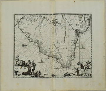
Sold20231671 Ogilby Map of Brazil -- BrasiliaTitle: 1671 Ogilby Map of Brazil -- Brasilia Cartographer: J Ogilby Year / Place: 1671, London Map Dimension (in.): 11.3 X 13.8 in. This is an excellent map of the eastern part of Brazil. There is anSee Sold Price
Sold2022La Polonia divisa ne' suoi Palatinati…. Poland Lithuania &c. ZATTA 1783 mapTITLE/CONTENT OF MAP: 'La Polonia divisa ne' suoi Palatinati tratta dall' Atlante Polacco del Sig. Rizzi Zanoni' "Poland divided into its Palatinates or Voivodeships". The map covers the eastern partSee Sold Price
Jun 13Swann Auction Galleries(COLONIAL NEW YORK.) Major Samuel Holland. The Provinces of New York, and New Jersey; with part ofUS$1,100
3 days LeftEarly American History Auctions1853 Map of Portion of British North America and Gulf of St. Lawrence, by Henry PerleyUS$260
Jun 12Jasper52Amér. Sep. Parties des États-Unis #49. Missouri Illinois. VANDERMAELEN 1827 mapUS$260
Jun 13Swann Auction Galleries(WORLD.) Henry Teesdale; and John Dower (engraver). A New Chart of the WorldUS$1,500
3 days LeftSimpson Galleries, LLC.JULIUS BIEN (1826-1909) AN AMERICAN CIVIL WAR RECONNAISSANCE MAP, "Map of Texas and Part of NewUS$100
Jun 13Swann Auction Galleries(RUSSIA.) Vincenzo Maria Coronelli. Moscovia Parte Orientale / Parte Occidentale.US$450
Jun 12Jasper52City of York #9 Minster & Medieval centre. Aldwark Monkgate Hungate. OS 1852 mapUS$1,200


![Spanish North America. THOMSON. Texas, Mexico &: TITLE/CONTENT OF MAP: 'Spanish North America [northern part]' A large map of Texas, Mexico and the American Southwest, published in Edinburgh by John Thompson, based on the explorations of Humboldt an](https://p1.liveauctioneers.com/5584/132181/67157544_1_x.jpg?height=310&quality=70&version=1543975692)
![Spanish North America. THOMSON. Texas, Mexico & Southwestern USA 1817 map: TITLE/CONTENT OF MAP: Spanish North America [northern part] A large map of Texas, Mexico and the American Southwest, published in Edinburgh by John Thompson, based on the explorations of Humboldt and](https://p1.liveauctioneers.com/5584/320546/172232524_1_x.jpg?height=310&quality=70&version=1709072904)
![Spanish North America. THOMSON. Texas, Mexico & Southwestern USA 1830 map: TITLE/CONTENT OF MAP: Spanish North America [northern part] A large map of Texas, Mexico and the American Southwest. There are extensive observations of Native American Indian settlements and hunting](https://p1.liveauctioneers.com/5584/309982/165835454_1_x.jpg?height=310&quality=70&version=1700599538)


![Imperii Romani Distracta pars Orientalis. Roman Empire,: TITLE/CONTENT OF MAP: 'Imperii Romani Distracta, pars Orientalis [Roman Empire, eastern part]' DATE PRINTED: 1789 IMAGE SIZE: Approx 36.0 x 25.0cm, 14 x 9.75 inches (Large); Please note that this is a](https://p1.liveauctioneers.com/5584/139429/70692722_1_x.jpg?height=310&quality=70&version=1554845662)
![Imperia Antiqua, pars Orientalis. Empire of Alexander: TITLE/CONTENT OF MAP: 'Imperia Antiqua, pars Orientalis [The Empire of Alexander the Great, eastern part]' DATE PRINTED: 1789 IMAGE SIZE: Approx 36.5 x 25.5cm, 14.25 x 10 inches (Large); Please note t](https://p1.liveauctioneers.com/5584/156033/78749880_1_x.jpg?height=310&quality=70&version=1575421548)