Sold2022Lavoisne, C. V. 1830 Hand Col Map. Ancient World"Chart of the World as known to the Ancients on Mercators Scale and Division of the Earth among the Posterity of Noah" Hand Coloured Copper Engraved Map Published C1830, London for "A Complete GenealoSee Sold Price
Sold2016Map of known world of the ancients. 1835.Print of hand colored steel engraving titled „Monde connu des Anciens“.Author C. V. Monin.Engraved by unknown.From the „Atlas Universel de Geography“ by C. V. Monin. Parsi. 1835.See Sold Price
Sold2015Map of Ancient Italy. Europe. 1835.Print of hand colored steel engraving titled Italie Ancienne“.Author C. V. Monin.Engraved by unknown.From the Atlas Universel de Geography“ by C. V. Monin. Parsi. 1835.Italy officially the ItalianSee Sold Price
Sold20186 Maps incl: Seutter. Majestas Austriaca...[Austria/DC/Ancient World] 6 Maps. ++ Matthaus Seutter. Majestas Austriaca… C. 1730s-1740s. Detailed map showing rivers and towns in Austria. Hand colored. Border: 19 1/8 x 22 in. Frame: 30 1/2 x 35See Sold Price
Sold2024[WORLD]. ROBISON, Edward C. Manuscript double-hemisphere map of the world. 1831.[WORLD]. ROBISON, Edward C. Manuscript double-hemisphere map of the world. 1831. 1830 Manuscript double-hemisphere map of the world, in ink and colors, hand-colored in outline, within pink and green bSee Sold Price
Sold201918th C Map Ancient World JerusalemEngraved plate showing maps of ancient world including inset of Judea and Samaria and one of Jerusalem. Early 18th century.Very Good, trimmed to plate lines, measures 7 x 5.5". Reserve: $20.00 ShippinSee Sold Price
Sold2024Aitchison, Alexander 1799 Hand Col Map. World HemispheresOutline Hand Colored Copper Engraved Map Published 1798-99, London for "The Modern Gazetteer; Being a compendious Geographical Dictionary?" by Alexander Aitchison. Folds as issued. Paper Size: 10 x 8See Sold Price
Sold2023Russell & Barclay 1838 Hand Col Map. World Hemispheres"New World or Western Hemisphere" "Old World or Eastern Hemisphere" Hand Colored Steel Engraved Map Published 1823-40, by Fisher & Son, "A Complete Atlas of the World" by John Russell et al. A Very RaSee Sold Price
Sold2021Wilkes, John 1807 Hand Col Map. Ancient Britain"Britannia Antiqua" Finely Hand Colored Copper Engraved Map Published 1796-1828 London for "Encyclopaedia Londinensis, or universal dictionary of arts, sciences and literature" by John Wilkes et al. PSee Sold Price
Sold2021Wilkes, John 1807 Hand Col Map. Ancient Spain"Hispania Antiqua" Finely Hand Colored Copper Engraved Map Published 1796-1828 London for "Encyclopaedia Londinensis, or universal dictionary of arts, sciences and literature" by John Wilkes et al. PaSee Sold Price
Sold2023Martyn, John 1819 Hand Col Map. World Hemispheres. ClassicalHand Colored Copper Engraved Map Published 1819, London for "P. Virgilii Maronis Georgicorum Libri Quator. The Georgicks of Virgil" by John Martyn. Paper Size: 8.5 x 5 inch (22 x 13.5cm) Good ConditioSee Sold Price
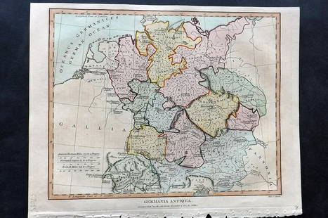
Sold2021Wilkes, John 1807 Hand Col Map. Ancient Germany"Germania Antiqua" Finely Hand Colored Copper Engraved Map Published 1796-1828 London for "Encyclopaedia Londinensis, or universal dictionary of arts, sciences and literature" by John Wilkes et al. PaSee Sold Price
Sold2023Russell & Barclay 1832 Hand Col Map. Chart of the WorldHand Colored Steel Engraved Map Published 1823-40, by Fisher & Son, "A Complete Atlas of the World" by John Russell et al. A Very Rare Work which is compiled from the same plates used in different ediSee Sold Price
Sold2022Harris (Pub) 1820 Hand Col World Hemisphere Map"The Two Hemispheres" Hand Colored Copper Engraved Map Published 1820 by J. Harris & Son., London for "The Traveller; Or, An Entertaining Journey Round the Habitable Globe" Paper Size: 6 x 4 inch (16See Sold Price
Sold2022Ortelius - Aevi Veteris, Typus GeographicusAbraham Ortelius (1527-1598), Aevi Veteris, Typus Geographicus, Antwerp, circa 1624, text verso, in two sheets, engraving on laid paper with hand colored highlights, map of the ancient world based onSee Sold Price
Sold2016c. 1760s, Hand-Colored World Map, “Mappa Mondo”Historic Maps 1760 Hand-Colored World Map, Siena Presso Pazzini Carli c. 1760s, Hand-Colored World Map, “Mappa Mondo,” Printed & Colored by Siena Presso Pazzini Carli, Choice Very Fine. A fine GobSee Sold Price
Sold2023Russell & Barclay 1840 Hand Col Map. Mexico with Southern USAHand Colored Copper Engraved Map Published 1823-40, by Fisher & Son, "A Complete Atlas of the World" by John Russell et al. A Very Rare Work which is compiled from the same plates used in different edSee Sold Price
Sold2023Russell & Barclay 1832 Hand Col Map. Canada. British Dominions in North AmericaHand Colored Steel Engraved Map Published 1823-40, by Fisher & Son, "A Complete Atlas of the World" by John Russell et al. A Very Rare Work which is compiled from the same plates used in different ediSee Sold Price
Sold2022Barclay, James C1800 Hand Col Map. Western Hemisphere"The New World or Western Hemisphere" Hand Colored Copper Engraved Map Published C1800 Halifax & Newcastle, England for "Barclay's Universal English Dictionary…" by James Barclay. Maps Engraved by CSee Sold Price
Sold2023Russell & Barclay 1839 Hand Col Map. North AmericaHand Colored Copper Engraved Map Published 1823-40, by Fisher & Son, "A Complete Atlas of the World" by John Russell et al. A Very Rare Work which is compiled from the same plates used in different edSee Sold Price
Sold2018UK - Staffordshire 1808 Hand Col Map by Charles Smith"A New Map of the County of Stafford" Copper Engraved Map Published 1808, London. Printed for C. Smith. Dissected and linen backed. Original hand colour. Paper Size: 20.5 x 19 inch (52 x 48cm) Good coSee Sold Price
Sold2023Russell & Barclay 1839 Hand Col Map. PolandHand Colored Copper Engraved Map Published 1823-40, by Fisher & Son, "A Complete Atlas of the World" by John Russell et al. A Very Rare Work which is compiled from the same plates used in different edSee Sold Price
Sold2023Russell & Barclay 1839 Hand Col Map. AfricaHand Colored Copper Engraved Map Published 1823-40, by Fisher & Son, "A Complete Atlas of the World" by John Russell et al. A Very Rare Work which is compiled from the same plates used in different edSee Sold Price
Sold2023Russell & Barclay 1839 Hand Col Map. Chart of the East India IslandsHand Colored Copper Engraved Map Published 1823-40, by Fisher & Son, "A Complete Atlas of the World" by John Russell et al. A Very Rare Work which is compiled from the same plates used in different edSee Sold Price
6 days LeftTrillium Antique Prints & Rare BooksMitchell's A New Universal Atlas.. - Volume with 73 MapsUS$1,000(1 bid)
2 days LeftAdam's AuctioneersCAREY'S General Atlas Improved and Enlarged, being a Collection of Maps of the World and Quarters,€2,600(2 bids)
2 days LeftJasper521886 Adams Chronological Chart of Civilizations -- A Chronological Chart of Ancient, Modern andUS$550
May 11Oriental Art AuctionsA COLOSSAL SCULPTED WHITE MARBLE MODEL OF THE HEAD OF HERCULES, 20TH CENTURY€9,000
May 11ZevantiquesAn exquisite late18th -early 19th C. Mughal Indian talwar with the hilt embellishedUS$1,000(1 bid)


![6 Maps incl: Seutter. Majestas Austriaca...: [Austria/DC/Ancient World] 6 Maps. ++ Matthaus Seutter. Majestas Austriaca… C. 1730s-1740s. Detailed map showing rivers and towns in Austria. Hand colored. Border: 19 1/8 x 22 in. Frame: 30 1/2 x 35](https://p1.liveauctioneers.com/179/122672/62428327_1_x.jpg?height=310&quality=70&version=1527272450)
![[WORLD]. ROBISON, Edward C. Manuscript double-hemisphere map of the world. 1831.: [WORLD]. ROBISON, Edward C. Manuscript double-hemisphere map of the world. 1831. 1830 Manuscript double-hemisphere map of the world, in ink and colors, hand-colored in outline, within pink and green b](https://p1.liveauctioneers.com/197/321050/172516760_1_x.jpg?height=310&quality=70&version=1709074257)