Sold2016[Map] English Road Map18th century; watercolored, London to Barwick, framed 23 in. L., 19 in. H.See Sold Price
2019Early English road map by John OgilbyHeading: (Maps) Author: Ogilby, John Title: The Road from London to St. Neotts in Com. Hunt. Continued to Oakeham in Com Rutland Place Published: London Publisher: Date Published: 1675See Sold Price
Sold20231736 English Road Maps Cambridge, Bath-Bristol, Lancaster- York & Knaresburg1736 Cambridge hand colored 5 x 7 in frame, Lancaster and York, Knaresburg 2 sided in open matt 5 x 7, and Bath to Bristol framed 4 x 6 inches in matt.See Sold Price
Sold2022Rare Late 1700's English Road Mapsc.1790 English hand-colored road maps, published by J. Cary, showing inns & pubs along the road. Lewisham to turnbridge Wells. Includes Lee, Eltham, Farningham & Maidstone etc. Maps on both front & baSee Sold Price
Sold201918TH CENTURY LONDON TO HOLY HEAD ROAD ENGRAVINGEnglish road map engraving by John Ogilby "London to Holy Head" from 1735. Measures 27.5" x 23" w/ frame.See Sold Price
Sold201918TH CENTURY LONDON TO CARLISLE ROAD ENGRAVINGEnglish road map engraving by John Ogilby "London to Carlisle" from 1735. Measures 27.5" x 23" w/ frame.See Sold Price
Sold2022Thomas Gardner, English Hand Colored Road MapDepicting the roads from Exeter to Dorchester and from Plymouth to Dartmouth, inscribed to the honorable Nathaniel Napier, originally published in 1719. Nicely hand colored and framed. Sight size: 7"See Sold Price
Sold2022Pair of English Map Plates, by Ogilby.Artist: John Ogilby. Title/Subject: "The Road from Hereford to Leicester"; and "The Continuation of the Road from Chester to Cardiff com. Glamorgan." Size: Each 15in x 19in; 16 3/4in x 20 1/2in (frameSee Sold Price
Sold20174 English Maps & EngravingsFour (4) English maps and engravings, including Ogibly, Speed, Chavane. 1st item: "98. The Road from Shrewsbury to Chester to Holywell Co. Flint.", by John Ogilby (United Kingdom, 1600-1676), from hisSee Sold Price
Sold2022Antique Map of Europe - County Map of Glamorganshire - Wales - United KingdomAntique map of Glamorganshire. Place names, topography, roads and railways are shown in significant detail by Joshua Archer. 'The Universal English Dictionary ...' by Rev. James Barclay, published inSee Sold Price
Sold2022Antique Map of Europe - County Map of Huntingdonshire - Wales - United KingdomAntique map of Huntingdonshire. Place names, topography, roads and railways are shown in significant detail by Joshua Archer. 'The Universal English Dictionary ...' by Rev. James Barclay, published inSee Sold Price
Sold2022Antique Map of Europe - County Map of Herefordshire - Wales - United KingdomAntique map of Herefordshire. Place names, topography, roads and railways are shown in significant detail by Joshua Archer. 'The Universal English Dictionary ...' by Rev. James Barclay, published in LSee Sold Price
Sold20201798 1ed Cary ROADS New Itinerary England Wales1798 1ed Cary ROADS New Itinerary England Wales Topography Atlas Travel Guide John Cary was a famous English cartographer from the 18th-century. Cary gained his reputation as a map maker from his workSee Sold Price
Sold20211930s Southern California Map -- Road Map SouthernTitle: 1930s Southern California Map -- Road Map Southern section of California Cartographer: Automobile Club of Southern California Year / Place: mid 1930s, Los Angeles Map Dimension (in.): 16.8 X 31See Sold Price
Sold2020Road Map of New MexicoTitle/Content of Map: Road Map of New Mexico Date: 1936 Cartographer: GOUSHA, H. M. CO. Publisher: STANDARD OIL COMPANY OF TEXAS Size: 23Height - 17Width Full color road map. Entire US on reverse. CovSee Sold Price
Sold2022VINTAGE NORTH EASTERN US & FRENCH ROAD MAPSVINTAGE NORTH EASTERN US & FRENCH ROAD MAPS Road maps of the eastern seaboard of PA, NY, D.C., VA, MD, and NJ by AAA and Exxon. Also included are five Michelin maps of France.See Sold Price
Sold2024Keith Haring Artwork Signed on a Shell Oil New York Road Map 18 in. x 24 in.Keith Haring Artwork Signed on a Shell Oil New York Road Map 18 in. x 24 in. size: 18 x 42 open - rippingSee Sold Price
Sold2022Antique 1719 English Map of the Chesapeake Bay by John SenexAntique early English map of the Chesapeake Bay, showing the principal settlements of this tobacco and cotton producing region. Engraved in London in 1719 by John Senex map is titled The Sea of VirginSee Sold Price
Sold2021Early English map of U.S. 1783Heading: Author: Kitchin, Thomas Title: Map of the United States in North America: with the British, French and Spanish Dominions adjoining, according to the Treaty of 1783. Place Published: London PSee Sold Price
Sold2022HUSKY GASOLINE SERVICE STATION MAP DISPLAY W/ HUSKY ROAD MAPS.SST. An excellent and complete example of this Circa 1950's Service Station Road Map Display from Husky showing a Tin Husky Sign at the face and complete with Maps. CONDITION: Display is in overall exSee Sold Price
Sold2022New road map of the city of Paris 1839 Rosselin editeur engravingNouveau plan routier de la ville de Paris, Guide exacte de cette capitale : en 12 arrondissemens avec leurs mairies et en 48 quartiers, 1839V. ROSSELIN (19th century), print editor, Paris, EstablishedSee Sold Price
Sold2022British road maps.- Ogilby (John) The Roads fromNO RESERVE British road maps.- Ogilby (John) The Roads from Chelmsford in Essex to St. Edmonds-Bury in Suffolk & Saffron-Walden in Essex, strip road map, engraving with hand-colouring, on thin laid paSee Sold Price
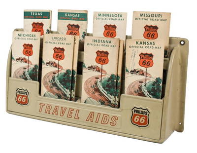
Sold2023Vintage Phillips 66 Road Map Embossed Display RackVintage Phillips 66 embossed plastic road map display rack full with original 1930s Phillips 66 maps. Rack has discoloration, some expected chips/ cracks, and wear from use and age. Displays well withSee Sold Price
2 days LeftForum AuctionsAmerica.- Moellhausen (Baldwin) Diary of a Journey from the Mississippi to the Coasts of the£50
May 30NY Elizabeth ERNEST FLOYER'S 1882 UNEXPLORED BALUCHISTAN ANTIQUE MAP ILLUSTRATED IN ENGLISHUS$50
2 days LeftJasper52SIBERIA & CHINESE TARTARY Manchuria Mongolia Korea China Silk road SDUK 1846 mapUS$20
2 days LeftJasper52SIBERIA & CHINESE TARTARY Manchuria Mongolia Korea China Silk road SDUK 1851 mapUS$25
1 day LeftThomaston Place Auction GalleriesEARLY 17TH C. ELIZABETHAN ENGRAVED MAP OF CORNWALL BY WILLIAM KIP AFTER WILLIAM SAXTONUS$150
Jun 23Schilb Antiquarian Rare Books1890 Livingstone 1ed In Darkest Africa Henry Stanley Emin Pasha Expedition MAPUS$16(3 bids)
Jun 02Schilb Antiquarian Rare Books1871 Alfred the Great King of England MAP Battle of Ashdown Vikings Thom HughesUS$125(3 bids)
18 hrs LeftJasper521892 Cowles Civil War Map of Battles in Gettysburg, Virginia, W Virginia and Maryland -- Sketch ofUS$75(2 bids)


![[Map] English Road Map: 18th century; watercolored, London to Barwick, framed 23 in. L., 19 in. H.](https://p1.liveauctioneers.com/523/84219/43476550_1_x.jpg?height=310&quality=70&version=1453240168)
![[Map] English Road Map First Image](https://p1.liveauctioneers.com/523/84219/43476550_1_x.jpg?height=300&quality=1&version=1453240168&width=300)
![[Map] English Road Map First Image](https://p1.liveauctioneers.com/523/84219/43476550_1_x.jpg?height=300&quality=95&version=1453240168&width=300)


![[MAP]. SPEED, John. A New Mappe of the Romane Empire. 1676. (1 of 2)](https://p1.liveauctioneers.com/197/329395/177650541_1_x.jpg?height=282&quality=70&version=1715364962)


