Sold2023Jacques DuGlass. Fictitional Map.Jacques DuGlass. Fictional Map. Not signed or dated. Pencil on paper. Excellent condition. Image is 8.5"w x 11"h. Frame is 15"w x 18"h. Est. $200-300. Ship: $45See Sold Price
Sold2019Andrews' Series of Wall Maps. Map of the United StatesTitle/Content of Map: Andrews' Series of Wall Maps. Map of the United States Mexico and Parts Of Canada and the West Indies Date: c1889 Cartographer: G.W. Bacon Publisher: A.H. Andrews & Co. Size: 45HSee Sold Price
Sold2022Ottoman Empire, Palestine Operations, Railway Map Maps (22)Ottoman Empire, Palestine Operations, Railway Map Maps (22) Size 24 1/2 - 30 1/2 inches length aprox. A nice collection of 22 maps from the Ottoman Empire Palestine 1914-1918 for troops. all in originSee Sold Price
Sold2022[MAPS]. Map of the Pacific Rail Road and its Connections with the Seaports of the United States of[MAPS]. Map of the Pacific Rail Road and its Connections with the Seaports of the United States of America. New York: Johnson & Browning, 1860.  Lithographed map of the United States, hand-coloreSee Sold Price
SoldBOSTON MAPS. Map of the City of Boston, Massachusetts, Published by the City Planning Board.BOSTON MAPS. Map of the City of Boston, Massachusetts, Published by the City Planning Board. Engraved map on paper backed with linen, in black and white with blue, in folding sections with black cardSee Sold Price
Sold2022Map, "Map of San Francisco Showing Principal Streets and Places of Interest"Harrison Godwin (American, 1899-1984), "Map of San Francisco Showing Principal Streets and Places of Interest," 1927, published and drawn by Godwin, printed by Schmidt Litho., Co., S.F. sheet (unframeSee Sold Price
Sold2023Antique Map - Map of Canada - Hudson Bay - Labrador - Arctic Ocean - AmericasThis fine engraving map of Canada by Jacques-Nicolas Bellin originates from "Histoire générale des voyages..." by Antoine François Prévost d'Exiles in 1757. The author depicts Hudson's BaySee Sold Price
Sold2020A FACSIMILE CADASTRAL MAP, "Map of Harris County," LATEA FACSIMILE CADASTRAL MAP, "Map of Harris County," LATE 19TH/EARLY 20TH CENTURY, lithograph after the original on pale pink paper, showing downtown Houston connected by the Texas & New Orleans RailroaSee Sold Price
Sold2024TWO WORLD WAR II SILK ESCAPE MAPS. - Maps, 28 1/2 in. x 28 1/2 in. Pouch, 6 1/4 in. x 5 1/8 in.TWO WORLD WAR II SILK ESCAPE MAPS. Printed front and reverse with maps of European countries; includes maps "C/D" and "E/F" with original storage pouch.Issued to Special Operation Executive PersonnelSee Sold Price
Sold20191831 Hooker Lower and Midtown Manhattan Map -- Map ofTitle/Content of Map: 1831 Hooker Lower and Midtown Manhattan Map -- Map of the City of New York Date: 1871 reissue, New York City Cartographer: W Hooker Size: 15.4 x 12.2 in. Nicely color outlined MaSee Sold Price
Sold2020A FACSIMILE CADASTRAL MAP, "Map of Bexar County, "A FACSIMILE CADASTRAL MAP, "Map of Bexar County, " EARLY 20TH CENTURY, a reproduction of the original lithograph on pale pink paper, showing San Antonio and the "Town Tract," Salado Creek, Rio CibelSee Sold Price
Sold2019AN ANTIQUE MAP, "Map of Oklahoma and Indian Territory,"AN ANTIQUE MAP, "Map of Oklahoma and Indian Territory," 1890-1892, color engraving on paper, copyrighted by Mast, Crowell & Kirkpatrick, with view of Beaver. 10.375" x 13" Note: Showing populations oSee Sold Price
Sold202440+ Asst 1940s-Newer Maps- Army, Declassified, More - Army Corps Engineers, US Army Maps - Maps from40+ Asst 1940s-Newer Maps- Army, Declassified, More - Army Corps Engineers, US Army Maps - Maps from around the World - 1:50,000 + 1:1,000,000 ScaleSee Sold Price
Sold20181871 Hardy New York City Fire Department Map -- Map ofTitle/Content of Map: 1871 Hardy New York City Fire Department Map -- Map of the Boundaries of the Fire Department of the City of New York Made Under the Direction of the Fire Commissioners Date PrintSee Sold Price
Sold2024Antique Map - Map representing the peninsula of Florida - United States - Andrea ScacciatiThis wonderful engraving " Carta rappresentante la Penisola della Florida" (Map representing the peninsula of Florida.) originates from "ll Gazzettiere americano contenente un distinto ragguaglio di tSee Sold Price
Sold2019[Map] Map of Jerusalem, 18th centuryMap of Jerusalem. London, 1689 (but likely early 1700s). 21.5" x 17". On heavy laid paper. With stub along vertical crease and two other vertical creases (as once bound, folding), a few short closed tSee Sold Price
Sold20191901 Bien Seminole Nation Map -- Map of Seminole NationTitle/Content of Map: 1901 Bien Seminole Nation Map -- Map of Seminole Nation Showing Progress of Allotment Date: 1901, Washington Cartographer: J Bien & Co. Size: 19 x 10 in. This map shows in greatSee Sold Price
Sold20201946 Greyhound US Route Map -- Map of Greyhound LinesTitle/Content of Map: 1946 Greyhound US Route Map -- Map of Greyhound Lines and Principal Connecting Lines Cartographer: Greyhound Year/Place: 1946 c. Size: 15 X 21.5 in. unfolded This is a nice foldiSee Sold Price
Sold2022Vintage Map - Map of San Diego Zoo - Zoological Society of San Diego - United StatesA whimsically colorful vintage map of San Diego Zoo - a fun cartoon print illustration from the 1983. You will receive the exact antique map in the photos. The condition is very good considering the aSee Sold Price
Sold2024Antique Map - Map of Canada - Quebec - Saint Lawrence River - Gaspesia - BellinThis hand-coloured fine engraving map of part of the Saint Lawrence River and Quebec, Canada by Jacques-Nicolas Bellin originates from "Histoire générale des voyages..." by Antoine François PrévosSee Sold Price
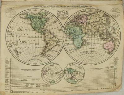
Sold20211831 Woodbridge World Map -- Map of the World AdaptedTitle: 1831 Woodbridge World Map -- Map of the World Adapted to Woodbridge's Geography Cartographer: W. Woodbridge Year / Place: 1831, Hartford Map Dimension (in.): 8.6 X 10.8 in. This is a very niceSee Sold Price
Sold20221946 Greyhound US Route Map -- Map of Greyhound Lines and Princial Connecting LinesTitle: 1946 Greyhound US Route Map -- Map of Greyhound Lines and Princial Connecting Lines Cartographer: Greyhound Year / Place: 1946 c. Map Dimension (in.): 15 X 21.5 in. unfolded This is a nice foldSee Sold Price
Sold2023Calmet, Augustin 1732 Large Map. Map of the Land of Promise. Israel Palestine"A Map of the Children of Israel's Travels and Marches in the Wilderness from their going out of Egypt..." Folio Copper Plate Published 1732, London for "An Historical, Critical, Geographical, ChronolSee Sold Price
Sold20191946 Greyhound US Route Map -- Map of Greyhound LinesTitle/Content of Map: 1946 Greyhound US Route Map -- Map of Greyhound Lines and Princial Connecting Lines Date: 1946Cartographer: Greyhound Size: 15 X 21.5 in. unfolded This is a nice folding map showSee Sold Price
2 days LeftSchilb Antiquarian Rare Books1977 JRR Tolkien 1st ed Silmarillion Lord of the Rings Middle Earth + MAPUS$155(7 bids)
6 days LeftSwann Auction Galleries(PANAMA.) George U. Mayo. Letter from a survivor of the ill-fated Darien Exploring Expedition,US$1,500
1 day LeftTrillium Antique Prints & Rare BooksSanson - Map of the Antilles Islands or West Indies with part of FloridaUS$75
Freeman's | Hindman[MAPS]. A group of 8, incl. 5 maps of North America, one of the western hemisphere, & 2 engravings.US$150
1 day LeftTrillium Antique Prints & Rare BooksPrevost - Volume 16 with 31 Maps & Engravings (Including Map or Australia)US$210(2 bids)
Aug 06Joe R. Pyle Complete Auctions & Real Estate"Texaco Tourguide" Metal Map Rack w/Maps and metal wall mount map holderUS$5
3 days LeftRapid Estate Liquidators and Auction GalleryVintage Boardwalk And Baseball Employee GuidesUS$45


![[MAPS]. Map of the Pacific Rail Road and its Connections with the Seaports of the United States of: [MAPS]. Map of the Pacific Rail Road and its Connections with the Seaports of the United States of America. New York: Johnson & Browning, 1860.  Lithographed map of the United States, hand-colore](https://p1.liveauctioneers.com/197/265300/138516599_1_x.jpg?height=310&quality=70&version=1666052782)


![[Map] Map of Jerusalem, 18th century: Map of Jerusalem. London, 1689 (but likely early 1700s). 21.5" x 17". On heavy laid paper. With stub along vertical crease and two other vertical creases (as once bound, folding), a few short closed t](https://p1.liveauctioneers.com/3532/146911/74242515_1_x.jpg?height=310&quality=70&version=1564368564)


![[MAPS - LOUISIANA]. Map of Louisiana from D'Anville's Atlas. London, 1788. (1 of 0)](https://p1.liveauctioneers.com/dist/images/placeholder.jpg?height=282&quality=70)


