Sold2022Faden Map of the Battle of Hobkirk's Kill, Revolutionary War, 1781FADEN, William (1749 – 1836). Sketch of the Battle of Hobkirks Hill, near Camden on the 25th April, 1781. Engraved map. London: Faden, Aug. 1, 1783. 21 3/4" x 15 1/8" sheet. This RevolutionarySee Sold Price
Sold2022Faden Map of the Plan of the Attack of the Forts Clinton & Montgomery with beautiful original handFADEN, William (1749-1836). Plan of the Attack of the Forts Clinton & Montgomery upon Hudsons River which were Stormed by His Majesty's Forces under the Command of Sir Henry Clinton, 6th of Octr. 1777See Sold Price
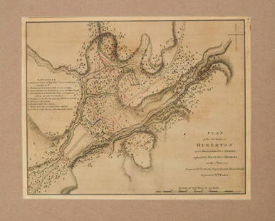
Sold20211780 Faden Map of American Revolutionary War Battle inTitle: 1780 Faden Map of American Revolutionary War Battle in Vermont -- Plan of the Action at Huberton Under Brigadier Genl. Frazer, Supported by Major Genl. Reidesel, on the 7th July 1777 CartographSee Sold Price
Sold2019William Faden "Map of the Peninsula of India…" 1792**Originally Listed At $300** William Faden (British, 1749-1836), "A Map of the Peninsula of India from the 19th Degree North Latitude to Cape Comorin, MDCCXCII" - published in London, 1792. An antiquSee Sold Price
Sold20171755 “Historie von Spanien” Folding Map Spain Gibraltar“Historie von Spanien”, by Johann von Ferreras, printed at Halle by Johann Justin Gebauren. 1755. Included a folding map of Spain showing Gibraltar and islands in the Mediterranean. Measures 19 xSee Sold Price
Sold20241798 Faden Map of Africa -- Africa According to the Latest ExplorationsTitle: 1798 Faden Map of Africa -- Africa According to the Latest Explorations Cartographer: W Faden Year / Place: 1798, London Map Dimension (in.): 3.9 X 4.4 in. This is a very nice compact map of AfSee Sold Price
Sold20191803 Map of Gibraltar Fortifications1803 map of Gibraltar Bay and Surrounding area, published by Cadell and Davies, London, 1803. Fine, measures 8.25 x 10.5". Reserve: $20.00 Shipping: Domestic: Flat-rate of $5.00 to anywhere within theSee Sold Price
Sold2021Tallis, John (Pub) 1852 Map. Malta, Gibraltar, Corfu"British Possessions in the Mediterranean" Also showing Zante, Cephalonia. Steel Engraved Map with Original Outline Hand Color Published 1852-56 by John Tallis, London for "The Universal Pronouncing DSee Sold Price
Sold20222 Framed 18th C. Faden Maps - Greece & Denmark**Originally Listed At $200** Cartographer: William Faden (British, 1749-1836). Engraver: William Palmer (British, 1735-1812). "Graecie Antiquae et Aegaei Maris Tabula" Published by William Faden JanuSee Sold Price
Sold20201803 Two Maps Alexandria GibraltarTwo engraved maps publisshed by Cadell and Davies, London, 1803 "Sketch of the Canal of Alexandria" and of Gibraltar Bay. Very Good, momde discoloration. Each measuring 8.5 x 11". Reserve: $20.00 ShipSee Sold Price
Sold2017Bartholomew: Map of Routes to India, 1912Title/Content of Map: 'Routes to India; Inset maps of Gibraltar; Maltese Islands; Suez Canal' This map is folding hence the centrefold line may show on the image below Date Printed: 1912 Image Size: ASee Sold Price
Sold2017British Mediterranean Map, Tallis/Rapkin, 1851TITLE/CONTENT OF MAP: 'British Possessions in the Mediterranean' The map shows Gibraltar, Malta and Gozo, and the Ionian Islands including Corfu, Paxo, Zante, Cephalonia, Maura & Ithaca. The United StSee Sold Price
Sold2022BRITISH MEDITERRANEAN POSSESSIONS. Gib Malta Corfu Zante. RAPKIN/TALLIS 1851 mapTITLE/CONTENT OF MAP: 'British Possessions in the Mediterranean' The map shows Gibraltar, Malta and Gozo, and the Ionian Islands including Corfu, Paxo, Zante, Cephalonia, Maura & Ithaca. The United StSee Sold Price
Sold2019von Reilly: Gibraltar and Surrounding Spanish LandsCartographer: Franz Johann Joseph von Reilly Place/Date: Vienna / 1789 Size: 10 3/8" x 8 5/8" Condition: wash color; light overall age-toning A beautifully designed and colored German map of GibraltarSee Sold Price
Sold2018A.J. Johnson Map of France, Spain, and PortugalWith inset map of Gibraltar Rock. 23" X 17" (31.5" X 25")See Sold Price
Sold2017William Faden 1796 Map Eastern US, North AmericaFaden, William (BRITISH, 1749-1836); Map of the Eastern United States, North American with British Territories and Those of Spain according to the Treaty of 1784 (from a larger atlas), 1796; handcolorSee Sold Price
Sold2024Europe exhibiting its principal states &c. First French Empire. FADEN 1791 mapTITLE/CONTENT OF MAP: 'Europe exhibiting its principal states &c' DATE PRINTED: 1791 IMAGE SIZE: Approx 54.5 x 69.5cm, 21.5 x 27.25 inches (Large); Please note that this is a folding map. TYPE: LargeSee Sold Price
Sold2022Map, Andalusia Castellum Gibraltar, Matthai (Matthias)Map, Andalusia Castellum Gibraltar, Matthai (Matthias) Seutteri, showing Gibraltar, South of Spain & several insets Minorca, Gibraltar, early part of the 18th Century, map is 19.25" by 22.25" (sight),See Sold Price
Sold2023Baedeker, Karl 1901 Lot of 34 Antique Maps. Spain & Portugal incl MajorcaIncl 2 of Majorca and one of Gibraltar. Lithograph Maps Published 1901, Leipzig for "Spain and Portugal. Handbook for Travellers" by Karl Baedeker. Folds as issued. Paper Size: Up to 10.5 x 8 inch (27See Sold Price
Sold2023Baedeker, Karl 1901 Lot of 34 Antique Maps. Spain & Portugal incl MajorcaIncl 2 of Majorca and one of Gibraltar. Lithograph Maps Published 1901, Leipzig for "Spain and Portugal. Handbook for Travellers" by Karl Baedeker. Folds as issued. Paper Size: Up to 10.5 x 8 inch (27See Sold Price
Sold2017Faden & Stedman: Antique Map, Seige of Savannah, 1794Title/Content of Map: Seige of Savannah Date Printed: 1794 Cartographer: Faden & StedmanMaterial/Medium: Engraving Size: 28 1/2" x 22 1/2" Original engraving from Stedman's History of the American WarSee Sold Price
Sold2024Faden Revolutionary War Map of SaratogaFADEN, William (1749-1836). Plan of the Position which the Army under Lt. Genl. Burgoine took at Saratoga on the 10th of September 1777, and in which it remained till the Convention was signed. EngravSee Sold Price
Sold2024Faden Revolutionary War Map of HubertonFADEN, William (1749-1836). Plan of the action at Huberton under Brigadier Genl. Frazer, supported by Major Genl. Reidesel, on the 7th July 1777. Drawn by P. Gerlach Deputy Quarter Master General. EngSee Sold Price
Sold2018India.- Faden (William) A Map of the Peninsula of IndiaIndia.- Faden (William) A Map of the Peninsula of India from the 19th Degree North Latitude to Cape Comorin, impressive two sheet map of the Indian subcontinent, extending from Bombay and Aurungabad,See Sold Price
May 12Schilb Antiquarian Rare Books1844 Siege of Gibraltar American Revolution SPAIN France Drinkwater MAP HistoryUS$1(1 bid)
3 days LeftDoyle New YorkThe top sheet of the famous Ratzer Map - with additions relating to an 1810 real estate disputeUS$7,500
Featured2 days LeftJasper52George Augustus, Lord Heathfield Eliott - Antique engraving after Reynolds by Paul Adolphe Rajon,US$40
May 14Fleischer's Auctions1755 Map Partie de l'Amerique Septentrionale, qui comprend Le Cours de L'Ohio...US$200(3 bids)
May 05Tremont AuctionsJohn Speed and Francis Lamb "Map of New England and New York", ca. 1676. Hand colored engraved mapUS$900(3 bids)
May 05Tremont Auctions17th century original map 1676 "Virginia and Maryland" by John Speed. 2 sided framing. Overall:US$325(2 bids)
2 days LeftFreeman's | HindmanAmerican School 19th century, A School Girl Map of FloridaUS$250(1 bid)
May 05Tremont Auctions18th century map of New Jersey. "A New and Accurate Map of New Jersey". W. Long, London. Map size 13US$100
May 11Crescent City Auction GalleryWilliam H. Williams (1817-1886), New Orleans "Map of the Sixth District and Carrollton," 1871, H.-US$650
May 12Schilb Antiquarian Rare Books1977 JRR Tolkien 1st ed 1st Printing Silmarillion Lord of the Rings + MAP + DJUS$200(5 bids)
4 days LeftDixon's Crumpton AuctionPre-Central Park Map of New York City, David H. Burr / Simeon DeWitt 1829US$125(3 bids)
May 09Hunt and Peck Estate Services, Inc.Jacques Nicolas Bellin Map Of Western Part Of New France Or CanadaUS$200(1 bid)
May 05Tremont Auctions18th century map "Americae Septentrion" by Homann. Rarer early edition. Framed. Holes around outerUS$250(1 bid)
6 hrs LeftSouth Jersey Auction by Babington Auction IncFramed map of North America and Central AmericaUS$25(1 bid)
6 hrs LeftSouth Jersey Auction by Babington Auction IncVintage framed map of South Western Highlands of New JerseyUS$25(1 bid)