Sold2017Map of Boston Harbor, 1882Map: Boston Harbor Cartographer: Walker-Potter, British Admiralty Place & Date: London / 1882 Size: 38 3/4" x 26 1/2" Condition: b&w, minor marginal nicks A spectacularly detailed British Admiralty chSee Sold Price
Sold2017Boston Harbor and the North ShoreTitle/Content of Map: Boston Harbor and the North Shore Date Printed: 1907 Cartographer: Walker Lithograph and Publishing Company Size (in): 20 x 13 Orginal antique birdseye view folding map of BostonSee Sold Price
Sold2017A FRAMED 1879 MAP OF BOSTON HARBOR BY THAXTER AND SONSA FRAMED 1879 MAP OF BOSTON HARBOR BY THAXTER AND SONS PUBLISHERS. 23" x 15 1/2" SITE TEARS AT BORDERSSee Sold Price
Sold20221878 HUGE MAP of Massachusetts & Boston Harbor Rand McNally Plymouth1878 HUGE MAP of Massachusetts & Boston Harbor Rand McNally Plymouth Rand McNally was a notable 19th and early 20th-century American publishing company known for their maps and travel atlases. This enSee Sold Price
Sold2021GEORGE F. CRAM Map of BostonGEORGE F. CRAM Map of Boston, signature to middle right, verso reads ‘ George Cram, Boston, about 1900’, subject map of Boston and Boston Harbor, measures 19 3/8 x 25 1/4 inches, window measures 1See Sold Price
Sold2022FRAMED VINTAGE 20'S TRAVEL MAP BIRD'S EYE VIEW OF BOSTON HARBOR 15 3/4" X 20" W/ COVER 7" X 7 1/2"FRAMED VINTAGE 20'S TRAVEL MAP BIRD'S EYE VIEW OF BOSTON HARBOR 15 3/4" X 20" W/ COVER 7" X 7 1/2"See Sold Price
Sold2023Vintage, 'Shipwrecks of Boston Harbor" Pictorial Chart Map, 20th centuryVintage, "Shipwrecks of Boston Harbor" Pictorial Chart Map, 20th century, role call of 75 major wrecks. Overall 25.25 in. x 28.25 in.See Sold Price
Sold2016Map of Boston & Vicinity, 1868Original engraving from Johnson's Atlas of the World, 1868. Map details city streets, neighborhoods and Boston Harbor & Charles River. Dimensions: 18" x 26". No Reserve This item ships from Ocean ViewSee Sold Price
Sold20171892 Map of Boston areaNineteenth century map of greater Boston. Map shows Hingham, Cohasset, Milton, Marblehead, out to Carlisle, Framingham and Sherborn. The legend reads published at the Boston Map Store: Damrell and UphSee Sold Price
Sold2016Original 1892 Map of Provincetown1892 map of Provincetown by Walker. Map shows Wellfleet, Truro, and Provincetwon with all roads of the day. Nicely framed. Overall Dimensions: 31" x 24"See Sold Price
Sold2019Cohasset harbor map and chartWAR DEPARTMENT MAP AND CHART OF COHASSET HARBOR. Detailed map of the South Shore from Boston to Cohasset showing harbors and coves including Whitehead, Bailey Creek, Bassing Beach etc.. Framed . DimenSee Sold Price
Sold2021FRAMED MAP OF CAPE CODFramed map of Cape Cod. Very colorful. Drawn by Clara Chase. 35H X 28WSee Sold Price
Sold2016Original Map of Indiana and KentuckyOriginal, early Map showing Indiana and Kentucky in frame. Dimensions: 20" H x 22" WSee Sold Price
Sold20161771 Map of East River1771 map of a small portion of Manhattan's East River at Tuttle bay, now known as Turtle Bay. It extends from 43rd to 53rd streets. Tuttle Bay is described as a farm. Framed and matted. Dimensions: 22See Sold Price
Sold2016Rare, 1890s Map of MaineRare map of Maine, “Freeport Sheet†by the US Geological survey from 1890. Shows islands and necks within Casco Bay as well as Freeport, Cumberland, Brunswick and surrounding towns. Matted aSee Sold Price
Sold2017John Murphy: Bird's Eye View of Boston Harbor, 1899Map: Untitled (Cover Title: Bird's Eye View of Boston Harbor and South Shore to Provincetown Showing Steamboat Routes) Maker: John F. Murphy Publisher: John F. Murphy, Boston Date: 1899 Size: Folio -See Sold Price
Sold2024WWII LotWWII ephemera lot. Includes book "ON TARGET", book "THE 301st SUPPLY TRAIN IN THE WORLD WAR", folded map, "PICTORIAL HISTORY OF THE HARBOR DEFENSES of BOSTON" (1941), along with early German militarySee Sold Price
Sold2023Steamship Builders Model of " S.S. Belasco"1921 Dockyard builders model of the "S.S.Belasco", built by Messers John I Thornycroft & Co Limited, Woolston Works, Southampton ' for Dover Shipping Company, hull. Length 300 Feet, Beam 43, Draught 2See Sold Price
Sold2023Isaac Sailmaker oil on canvasIsaac Sailmaker oil of “British Warships in Port”. This large oil on canvas by “The father of British marine painting” displays many of the type of English warships of the lateSee Sold Price
Sold2023Fourth Order Fresnel Lighthouse LensExtremely rare Fourth Order Drum Lens with cut glass lenses set into a bronze frame with lifting handles. Sturdily built. Large and heavy. Early 20th Century. Dimension: 16 tall without handles,,,, 17See Sold Price
Sold2023Portia Takakjian Admiralty Style Model of Frigate EssexHighly regarded model of the Frigate Essex by noted female marine modeler Portia Takakjian. Portia wrote a book chronicling the research and building of this model and lectured as well. The model is bSee Sold Price
Sold2016Early 20th Century Yacht Builder's ModelExceptional prototype model from the renowned Gray Marine boatyard in Maine, circa 1920s. Exceptional detail. Fine cabin work. Hull form is very well scaled. Overall Dimensions: 58" x 13" x 30"See Sold Price
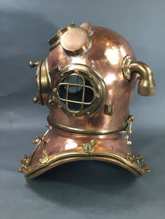
Sold2019SCHRADER COPPER DEEP SEA HELMET #1354Diving helmet serial number 1354 with complete brailes, four window designSee Sold Price
Sold2016Rare,Unopened 8 Bottle Erte Courvoisier CollectionRare, unopened, eight-bottle Limited Edition Courvoisier collection designed by Russian-born French artists Romain de Tirtoff Erte (1892-1990). The cognac bottles were designed to illustrate the cognaSee Sold Price
May 11Boston Harbor Auctions Thomas W Lawsons Polychromed Leather Nautical Panels from DreamwoldUS$6,500(2 bids)
May 11Boston Harbor Auctions Travel Agency model of the Liberte' (former Europa) by Art Models Studio.US$1,800(3 bids)
May 11Boston Harbor Auctions Bull Head Spigot from Coffee Urn salvaged from the wreck of schooner Thomas W LawsonUS$150(1 bid)