Sold2023VISSCHER C. 1680 PRUSSIA MAPEngraved map, with cartouche of Konigsburg. Center fold as issued. Dimensions: (Paper) H 21" x W 24" Condition: Repaired losses in margins. Handling marks, a few light surface stains.See Sold Price
Sold202317th century. A map of Dominium Mechliniense dating to 1636, attributed to Hondius/Janssonius.17th century. A map of Dominium Mechliniense dating to 1636, attributed to Hondius/Janssonius. Overall good condition considering age. Chipping at edges; toning throughout. Burn marks.See Sold Price
Sold2018Janssonius Map of East coastJANSSONIUS, Joannes. Nova Anglia Novum Belgium et Virginia. Copperplate engraving. Amsterdam, 1636 (first State). Burden 247. 18 3/4 x 22 1/2 inches sheetSee Sold Price
Sold2024Map, Jan JanssoniusJan Janssonius (Dutch, 1588-1664), "Nova Anglia, Novum Belgium et Virginia," engraving with color, overall (with frame): 21.5"h x 24.75"wSee Sold Price
Sold2023CARL FLEMMING (c. 1840-1879) A REPUBLIC OF TEXAS MAP, "Mexico, Mittel America, Texas," GLOGAU, CIRCACARL FLEMMING (c. 1840-1879) A REPUBLIC OF TEXAS MAP, "Mexico, Mittel America, Texas," GLOGAU, CIRCA 1846, a German lithograph on paper with hand color showing territories claimed by the Republic of TSee Sold Price
Sold2021[Maps & Atlases] Janssonius, Johannes Nova Belgica et[Maps & Atlases] Janssonius, Johannes Nova Belgica et Anglia Nova Amstelodami: Johannes Janssonius, (1652). 19 1/8 x 22 1/2 in. (486 x 571 mm). Second state. Hand-colored engraved map depicting the eaSee Sold Price
Sold2024WWI German Military Officer's Field Map w/ marksWWI German Military Map of the Amiens-St. Quentin region, handmarked with annotations from 1916 to 1918. These maps were created by the German Army's General Staff during World War I for military operSee Sold Price
Sold2023JANSSONIUS JOANNES MAP/ NOVA BELGICA & ANGLIA NOVAIdentified in pencil "Jansson 1650" on both sides. Double-page engraved map with Latin text verso; hand-colored in outline. printed on laid paper 19 3/4 x 23 inches (sheet) 23 x 27 inches (overall). PSee Sold Price
Sold2020Rolex, Ref. 1680 "Red" Submariner, Mark IV Dial,Rolex, Ref. 1680 "Red" Submariner, Mark IV Dial, circa 1970 Case: 40mm, stainless steel, three body case, with screw down caseback, No. 2769693 Dial: black dial with luminous hour markers, luminous skSee Sold Price
Sold2020Pierre Duval Nova Mexico Map ca. 1660 CaliforniaPierre Duval (1618-1683), "Nova Mexico," Nuremberg, ca. 1660-1680. This rare map depicts California as an island, based on Sanson's depiction, along with the surrounding areas of Mexico and what is noSee Sold Price
Sold2022WYTFLIET, CORNELIS VAN Granata Nova et California. [Louvain or Douai: circa 1597-1611].WYTFLIET, CORNELIS VAN Granata Nova et California. [Louvain or Douai: circa 1597-1611]. Copper-engraved map, without text on verso. Plate marks 9 1/8 x 11 1/4 inches (23 x 29 cm ), with larger marginsSee Sold Price
Sold2022LAET, JOHANNES DE Florida, et Regiones Vicinae. Leiden: circa 1630. Double-page engraved map onLAET, JOHANNES DE Florida, et Regiones Vicinae. Leiden: circa 1630. Double-page engraved map on watermarked laid paper. Plate marks 11 1/8 x 14 1/8 inches (28 x 36 cm), with slightly larger margins. ASee Sold Price
Sold2022c. 1680 Century Colonial Rare Forged Halberd HeadEdged Weapons 17th Century Halberd Head with Diamond Shaped Maker's Mark Blacksmith-Forged Iron "Bill" Style c. 1680 Late 17th Century, Rare Blacksmith-Forged Iron "Bill" Style Halberd Head, With a DiSee Sold Price
Sold2022A CHINESE ENAMEL GLAZED VASE WITH COVER, REPUBLIC PERIODQIANLONG FOUR CHARACTER MARK. H11cm, Currency: Price In USDSee Sold Price
Sold2016Beautifully Colored Jan Van Loon World MapOrbis Terrarum Nova... Jan Van Loon (c. 1611-1686). Engraved map with original hand color in full. London: Moses Pitt, 1680. 17 3/4 x 21 inches visible, 28 1/4 x 31 3/4 inches framed. A fine example oSee Sold Price
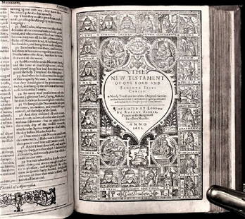
Sold20201612 King James Holy Bible, Genealogy / Map of CanonTHE HOLY BIBLE 1612 This is a very rare 1612 Quartos as there were very few produced to make ready for the 1613 Quartos.See Sold Price
Sold2017Stackhouse: Earliest Independent United States Map 1783Item: Earliest Independent United States Map Maker: Thomas Stackhouse Date: 1783 Measures 16" x 20 1/4" Map fully within boarder. Margin uneven on left side. Strong printing, plate mark easily visibleSee Sold Price
Sold2017Dutch 'American Septentrionalis' map, circa 1647Johannes Janssonius, known as Jan Jansson (Dutch, 1588-1664), hand colored copper engraving titled 'America Septentrionalis,' executed in Amsterdam circa 1647, depicting a cartographic amalgamation ofSee Sold Price
Sold2021(HOLY LAND.) Johannes Janssonius; and Georg Horn.(HOLY LAND.) Johannes Janssonius; and Georg Horn. [Regions of the 12 Tribes of Israel]. Together six double-page or folding engraved mapsheets to form a large wall map. Folio sheets, a few margins triSee Sold Price
Sold2020JANSSONIUS, JOHANNES; after HONDIUS, JODOCUS. AmericaJANSSONIUS, JOHANNES; after HONDIUS, JODOCUS. America Noviter Delineata. Double-page engraved map of the Americas. 19½x22½ inches sheet size, wide margins, Latin text on verso; original handSee Sold Price
Sold2020Sutton Nicholls (English, 1668-1729), , New map of theSutton Nicholls (English, 1668-1729)New map of the Most Considerable Plantations of the English America dedicated to His Highness the Duke of GlouchesterCirca 1680. Hand colored engraving.h: 21 in.; wSee Sold Price
Sold2023Borrower's Press Books & Rehab Map MiniaturesGroup of seven Borrower's Press printed books include Blake's Poetry, Christmas Songs, Aesop's Fables, Quilts, A Visit From Saint Nicholas, High Water Mark, Hansel & Gretel, also includes an unusual BSee Sold Price
Sold2020Des Barres Map of NY Harbor*** START PRICE IS THE RESERVE *** [America] DES BARRES, Joseph Frederick Wallet (1729-1824). A Chart of New York Harbour with the Soundings Views of Land Marks and Nautical directions for the Use ofSee Sold Price
Sold2020Tiffany Studios Gilt Bronze Cigar Box in Venetian #1680Tiffany & Co. Studios New York gilt bronze cigar box in Venetian #1680. An Italian Renaissance design with hand chased figural tailed animals to the ends. Tiffany Studio marks to the underside. WeightSee Sold Price
17 hrs LeftRiverdale Auction Inc.Chinese painting hunting map, Lang Shining's mark, Qing Dynasty, ChinaUS$200
17 hrs LeftRiverdale Auction Inc.Chinese "Fuchun Mountain Residence Map" hand scroll, Huang Gongwang's mark, Yuan Dynasty, ChinaUS$500
Oct 05Ripley Auctions“Visscher’s American Islands” Map (Insulae Americanae) by Nicolaes Visscher I (1619-1709)US$800
5 hrs LeftJasper52LONDON UNDERGROUND tube map diagram plan. Piccadilly extension. STINGEMORE 1931US$300
5 hrs LeftJasper52MOSCOW MOSKAU Москва Antique city town map plan & panorama SDUKUS$480
Oct 12JM Hobby Supply and Railroad Artifact AuctionsPittsburg Cincinnati and St Louis RY 9/18/1877 Special Chicago Excursion FlyerUS$40
3 days LeftTrillium Antique Prints & Rare BooksCatesby, Folio - Chattering Plover with Sorrel Tree. 1-71US$200
3 days LeftTrillium Antique Prints & Rare BooksCatesby, Folio - Little Brown Flycatcher & Red Eyed Flycatcher. 1-54US$200
3 days LeftTrillium Antique Prints & Rare BooksCatesby, Folio - Turn Stone or Sea Dottrel. 1-72US$200
3 days LeftTrillium Antique Prints & Rare BooksCatesby, Folio - Chamaedaphne (Mountain Laurel) with Pitch Apple. 2-98US$200
15 hrs LeftForum AuctionsTolkien (J.R.R.) The Lord of the Rings, 3 vol., first editions, 1954-55.£750
5 days LeftGERONTIUS AUCTIONCHINESE PORCELAIN YELLOW GROUND FAMILLE ROSE FORTUNE AND LONGEVITY VASE, YONGZHENG MARK£1,200(2 bids)
5 days LeftGERONTIUS AUCTIONCHINESE PORCELAIN FIVE COLORS SQUARE BEAST HEAD VASE, MING DYNASTY WANLI MARK£2,400(3 bids)


![[Maps & Atlases] Janssonius, Johannes Nova Belgica et: [Maps & Atlases] Janssonius, Johannes Nova Belgica et Anglia Nova Amstelodami: Johannes Janssonius, (1652). 19 1/8 x 22 1/2 in. (486 x 571 mm). Second state. Hand-colored engraved map depicting the ea](https://p1.liveauctioneers.com/65/217114/111330065_1_x.jpg?height=310&quality=70&version=1630684451)


![WYTFLIET, CORNELIS VAN Granata Nova et California. [Louvain or Douai: circa 1597-1611].: WYTFLIET, CORNELIS VAN Granata Nova et California. [Louvain or Douai: circa 1597-1611]. Copper-engraved map, without text on verso. Plate marks 9 1/8 x 11 1/4 inches (23 x 29 cm ), with larger margins](https://p1.liveauctioneers.com/292/250642/130213778_1_x.jpg?height=310&quality=70&version=1654271664)


![(HOLY LAND.) Johannes Janssonius; and Georg Horn.: (HOLY LAND.) Johannes Janssonius; and Georg Horn. [Regions of the 12 Tribes of Israel]. Together six double-page or folding engraved mapsheets to form a large wall map. Folio sheets, a few margins tri](https://p1.liveauctioneers.com/199/226915/117191999_1_x.jpg?height=310&quality=70&version=1637249113)


![Des Barres Map of NY Harbor: *** START PRICE IS THE RESERVE *** [America] DES BARRES, Joseph Frederick Wallet (1729-1824). A Chart of New York Harbour with the Soundings Views of Land Marks and Nautical directions for the Use of](https://p1.liveauctioneers.com/1968/163248/82424572_1_x.jpg?height=310&quality=70&version=1583340284)


