Sold2023VISSCHER C. 1680 PRUSSIA MAPEngraved map, with cartouche of Konigsburg. Center fold as issued. Dimensions: (Paper) H 21" x W 24" Condition: Repaired losses in margins. Handling marks, a few light surface stains.See Sold Price
Sold202317th century. A map of Dominium Mechliniense dating to 1636, attributed to Hondius/Janssonius.17th century. A map of Dominium Mechliniense dating to 1636, attributed to Hondius/Janssonius. Overall good condition considering age. Chipping at edges; toning throughout. Burn marks.See Sold Price
Sold2018Janssonius Map of East coastJANSSONIUS, Joannes. Nova Anglia Novum Belgium et Virginia. Copperplate engraving. Amsterdam, 1636 (first State). Burden 247. 18 3/4 x 22 1/2 inches sheetSee Sold Price
Sold2024Map, Jan JanssoniusJan Janssonius (Dutch, 1588-1664), "Nova Anglia, Novum Belgium et Virginia," engraving with color, overall (with frame): 21.5"h x 24.75"wSee Sold Price
Sold2021[Maps & Atlases] Janssonius, Johannes Nova Belgica et[Maps & Atlases] Janssonius, Johannes Nova Belgica et Anglia Nova Amstelodami: Johannes Janssonius, (1652). 19 1/8 x 22 1/2 in. (486 x 571 mm). Second state. Hand-colored engraved map depicting the eaSee Sold Price
Sold2023JANSSONIUS JOANNES MAP/ NOVA BELGICA & ANGLIA NOVAIdentified in pencil "Jansson 1650" on both sides. Double-page engraved map with Latin text verso; hand-colored in outline. printed on laid paper 19 3/4 x 23 inches (sheet) 23 x 27 inches (overall). PSee Sold Price
Sold20221680 deWit Map of Asia -- Accuratissima Totius AsiaeTitle: 1680 deWit Map of Asia -- Accuratissima Totius Asiae Tabula Recens Emendata Cartographer: F de Wit Year / Place: 1680 c. Amsterdam Map Dimension (in.): 19.3 X 22.9 in. This is a lovely large maSee Sold Price
Sold2017Janssonius: Antique Map of Virginia to Florida, 1639Map: Virginia to Florida Date Printed: 1639 Cartographer: Janssonius Joannes Material/Medium: Paper Size: 21 1/2" x 17 1/4" Hand colored, copperplate engraved. French edition. Virgina to Carolna coastSee Sold Price
Sold2017Janssonius: Antique Map of Portugal, 1645Title: Portugallia et Algarbia quae olim Lusitania. Attractive mid-17th century map of Portugal Map maker: Jan Janssonius Place and Year: Amsterdam, [c.1645] Dimensions: 38.5 x 49.5 cm (15¼ x 19½ inSee Sold Price
Sold2020Rolex, Ref. 1680 "Red" Submariner, Mark IV Dial,Rolex, Ref. 1680 "Red" Submariner, Mark IV Dial, circa 1970 Case: 40mm, stainless steel, three body case, with screw down caseback, No. 2769693 Dial: black dial with luminous hour markers, luminous skSee Sold Price
Sold2020Pierre Duval Nova Mexico Map ca. 1660 CaliforniaPierre Duval (1618-1683), "Nova Mexico," Nuremberg, ca. 1660-1680. This rare map depicts California as an island, based on Sanson's depiction, along with the surrounding areas of Mexico and what is noSee Sold Price
Sold2017(MAP, SICILY) DE WIT, FREDERICK. Insula sive regnumMAP, SICILY by DE WIT, FREDERICK, Insula sive regnum Siciliae urbibus praecipuis exornatum. Amsterdam, circa 1680. Hand-colored engraved map of Sicily. With inset plans of Messina, Milazzo and PalermoSee Sold Price
Sold2022WYTFLIET, CORNELIS VAN Granata Nova et California. [Louvain or Douai: circa 1597-1611].WYTFLIET, CORNELIS VAN Granata Nova et California. [Louvain or Douai: circa 1597-1611]. Copper-engraved map, without text on verso. Plate marks 9 1/8 x 11 1/4 inches (23 x 29 cm ), with larger marginsSee Sold Price
Sold2022LAET, JOHANNES DE Florida, et Regiones Vicinae. Leiden: circa 1630. Double-page engraved map onLAET, JOHANNES DE Florida, et Regiones Vicinae. Leiden: circa 1630. Double-page engraved map on watermarked laid paper. Plate marks 11 1/8 x 14 1/8 inches (28 x 36 cm), with slightly larger margins. ASee Sold Price
Sold2022c. 1680 Century Colonial Rare Forged Halberd HeadEdged Weapons 17th Century Halberd Head with Diamond Shaped Maker's Mark Blacksmith-Forged Iron "Bill" Style c. 1680 Late 17th Century, Rare Blacksmith-Forged Iron "Bill" Style Halberd Head, With a DiSee Sold Price
Sold2022A CHINESE ENAMEL GLAZED VASE WITH COVER, REPUBLIC PERIODQIANLONG FOUR CHARACTER MARK. H11cm, Currency: Price In USDSee Sold Price
Sold2016Beautifully Colored Jan Van Loon World MapOrbis Terrarum Nova... Jan Van Loon (c. 1611-1686). Engraved map with original hand color in full. London: Moses Pitt, 1680. 17 3/4 x 21 inches visible, 28 1/4 x 31 3/4 inches framed. A fine example oSee Sold Price
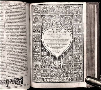
Sold20201612 King James Holy Bible, Genealogy / Map of CanonTHE HOLY BIBLE 1612 This is a very rare 1612 Quartos as there were very few produced to make ready for the 1613 Quartos.See Sold Price
Sold2017Stackhouse: Earliest Independent United States Map 1783Item: Earliest Independent United States Map Maker: Thomas Stackhouse Date: 1783 Measures 16" x 20 1/4" Map fully within boarder. Margin uneven on left side. Strong printing, plate mark easily visibleSee Sold Price
Sold2017Dutch 'American Septentrionalis' map, circa 1647Johannes Janssonius, known as Jan Jansson (Dutch, 1588-1664), hand colored copper engraving titled 'America Septentrionalis,' executed in Amsterdam circa 1647, depicting a cartographic amalgamation ofSee Sold Price
Sold2021(HOLY LAND.) Johannes Janssonius; and Georg Horn.(HOLY LAND.) Johannes Janssonius; and Georg Horn. [Regions of the 12 Tribes of Israel]. Together six double-page or folding engraved mapsheets to form a large wall map. Folio sheets, a few margins triSee Sold Price
Sold2020JANSSONIUS, JOHANNES; after HONDIUS, JODOCUS. AmericaJANSSONIUS, JOHANNES; after HONDIUS, JODOCUS. America Noviter Delineata. Double-page engraved map of the Americas. 19½x22½ inches sheet size, wide margins, Latin text on verso; original handSee Sold Price
Sold2020Sutton Nicholls (English, 1668-1729), , New map of theSutton Nicholls (English, 1668-1729)New map of the Most Considerable Plantations of the English America dedicated to His Highness the Duke of GlouchesterCirca 1680. Hand colored engraving.h: 21 in.; wSee Sold Price
Sold2023Borrower's Press Books & Rehab Map MiniaturesGroup of seven Borrower's Press printed books include Blake's Poetry, Christmas Songs, Aesop's Fables, Quilts, A Visit From Saint Nicholas, High Water Mark, Hansel & Gretel, also includes an unusual BSee Sold Price
4 days LeftLeland LittleHondius and Janssonius's Map of North America, with California as an IslandUS$275(4 bids)
2 days LeftJasper521680 Pitt Map of Northern France's Cambrai Commune -- Arcihiepiscopatus Cameracensis. Archevesche deUS$160(1 bid)
BonhamsWORLD MAP. LOON, JAN VAN. C 1611-1686. Orbis Terrarum Nova et Accuratissima tabula. [Oxford: Mo...US$2,400
BonhamsVENEGAS, MIGUEL. 1680-1764. Noticia de la California, y desu conquista temporal, y espiritual ha...US$7,000
2 days LeftRapid Estate Liquidators and Auction GalleryUniversal Studios Interactive Harry Potter Wand AUS$40
Freeman's | Hindman[MAPS & ATLASES]. Manuscript survey report and map of a Virginia estate, August 1872.US$150
2 days LeftDOYLE Auctioneers & AppraisersAn attractive eighteenth-century Dutch map of the AmericasUS$150
5 days LeftTrillium Antique Prints & Rare BooksCatesby, Folio - Little Sparrow with Purple Bindweed of Carolina. 1-35US$200
3 days LeftForum AuctionsTolkien (J.R.R.) The Lord of the Rings, 3 vol., mixed impressions, 1955-56; and 3 others (6)£150
5 days LeftTrillium Antique Prints & Rare BooksCatesby, Folio - Chattering Plover with Sorrel Tree. 1-71US$200(1 bid)
5 days LeftTrillium Antique Prints & Rare BooksCatesby, Folio - Snow Bird with Broom Rape & Toadstool. 1-36US$200
3 days LeftRail & Road AuctionsThree Delaware & Hudson Canal Company Railroad Annual Passes - 1876, 1877, and 1879US$70


![[Maps & Atlases] Janssonius, Johannes Nova Belgica et: [Maps & Atlases] Janssonius, Johannes Nova Belgica et Anglia Nova Amstelodami: Johannes Janssonius, (1652). 19 1/8 x 22 1/2 in. (486 x 571 mm). Second state. Hand-colored engraved map depicting the ea](https://p1.liveauctioneers.com/65/217114/111330065_1_x.jpg?height=310&quality=70&version=1630684451)


![Janssonius: Antique Map of Portugal, 1645: Title: Portugallia et Algarbia quae olim Lusitania. Attractive mid-17th century map of Portugal Map maker: Jan Janssonius Place and Year: Amsterdam, [c.1645] Dimensions: 38.5 x 49.5 cm (15¼ x 19½ in](https://p1.liveauctioneers.com/5584/110975/56961897_1_x.jpg?height=310&quality=70&version=1508432804)


![WYTFLIET, CORNELIS VAN Granata Nova et California. [Louvain or Douai: circa 1597-1611].: WYTFLIET, CORNELIS VAN Granata Nova et California. [Louvain or Douai: circa 1597-1611]. Copper-engraved map, without text on verso. Plate marks 9 1/8 x 11 1/4 inches (23 x 29 cm ), with larger margins](https://p1.liveauctioneers.com/292/250642/130213778_1_x.jpg?height=310&quality=70&version=1654271664)


![(HOLY LAND.) Johannes Janssonius; and Georg Horn.: (HOLY LAND.) Johannes Janssonius; and Georg Horn. [Regions of the 12 Tribes of Israel]. Together six double-page or folding engraved mapsheets to form a large wall map. Folio sheets, a few margins tri](https://p1.liveauctioneers.com/199/226915/117191999_1_x.jpg?height=310&quality=70&version=1637249113)


![[MAPS & ATLASES]. Manuscript survey report and map of a Virginia estate, August 1872. (1 of 0)](https://p1.liveauctioneers.com/dist/images/placeholder.jpg?height=282&quality=70)


