Sold2022MAP OF EASTERN SHORE OF MASSACHUSETTS AND THE COSTAL ISLANDSEarly 20th Century, American. Showing Barnstable County, Nantucket Island and Dukes Island, (Marthas Vineyard). Hand colored, 16 by 24.5 in., overall 25 by 33.5 in.See Sold Price
Sold2021Antique Map of North Eastern United StatesMap of North Eastern of the United States, Asher and Adams, signature to lower right reads Asher & Adams’ New Hampshire, Vermont, Massachusetts, Rhode Island and Connecticut, subject a map of EasterSee Sold Price
Sold20232 Topographical Maps of MASSACHUSETTS2 topographical maps of Massachusetts. 1 marked untied states, East coast, Rhode Island, Massachusetts. Narragansett Bay. Other marked Marthas Vineyard- Eastern Part. Largest map is approximately 47 xSee Sold Price
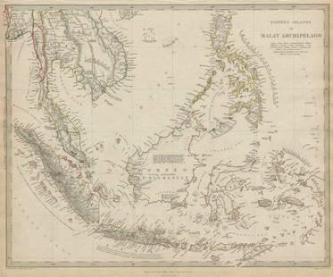
Sold2020MALAY ARCHIPELAGO Indonesia Malaysia PhilippinesTITLE/CONTENT OF MAP: 'EASTERN ISLANDS OR THE MALAY ARCHIPELAGO. Sumatra, Java, Borneo, etc' The top image on the right hand side shows the entire map. To view a close up of the map showing the levelSee Sold Price
Sold2020MALAY ARCHIPELAGO Indonesia Malaysia PhilippinesTITLE/CONTENT OF MAP: 'EASTERN ISLANDS OR THE MALAY ARCHIPELAGO. Sumatra, Java, Borneo, etc' The top image on the right hand side shows the entire map. To view a close up of the map showing the levelSee Sold Price
Sold2018Eastern Islands Or Malay ArchipelagoMap: Eastern Islands Or Malay Archipelago Date: 1852 Cartographer: WALKER, J. & C. Publisher: GEORGE COX/S.D.U.K. Size (inches): 12.5X16 Map showing southern Siam, Archipelago Filipino, Celebes, BorneSee Sold Price
Sold2018Tanner: Antique Map of Massachusetts & Rhode IslandTitle/Content of Map: Massachusetts & Rhode Island with insert of Boston by Tanner Date Printed: 1843 Cartographer: H.C. Tanner Material/Medium: Paper Size: 17" x 14" Hand colored engraved Map based oSee Sold Price
Sold2018Colton: Antique Map of Massachusetts & Rhode IslandTitle/Content of Map: Massachusetts & Rhode Island by Colton Date Printed: Cartographer: J.H. Colton Size: 14" x 17" Material/Medium: Paper Provenance: New York From 'Colton's General Atlas'. Hand colSee Sold Price
Sold2023Scarce 1850 RR map of Massachusetts & R. IslandStriking map of Massachusetts and Rhode Island, hand colored by counties, from the exceedingly difficult to obtain New Universal Atlas, published 1853 by Thomas, Cowperthwait & Co.. Highlights railroaSee Sold Price
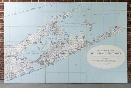
Sold2022Three Panel Water Current Map of Eastern Long Island on Canvas with FrameOver scaled Eastern Long Island water current map on three panel canvas, strengthened on frame. Please note of wear consistent with age. Each panel measures 48"W x 2"D x 96"H.See Sold Price
Sold20241853 Colton's Railroad & Township Map of Massachusetts, Rhode Island, and Connecticut1853 Colton's Railroad & Township Map of Massachusetts, Rhode Island, and ConnecticutA large 1853 railroad map of Massachusetts, Rhode Island, and Connecticut in a 29 1/2" x 25 1/2" frame. TSee Sold Price
Sold2018Antique Hand Colored Maps of MassachusettsAntique Hand Colored Maps of Massachusetts. This lot includes three 19th century hand colored maps. Includes one map of Annisquam,/Lanesville, one map of Massachusetts/Rhode Island/Connecticut, andoneSee Sold Price
Sold2016Map of Massachusetts, Connecticut & Rhode Island, 1868Original engraving from Johnson's Atlas of the World, 1868. Map includes vignette of Boston & details cities, towns and territories. Dimensions: 18" x 26". This item ships from Ocean View, DE.See Sold Price
Sold20231859 Map of Massachusetts and Rhode Island. Insert of Boston by ColtonTitle: 1859 Map of Massachusetts and Rhode Island. Insert of Boston by Colton1859 Materials: Steel engraved Size: 17 1/2 x 14 1/2” Massachusetts and Rhode Island. With insert of Boston and surroundiSee Sold Price
Sold20201855 Colton Map of Massachusetts and Rhode Island --Title: 1855 Colton Map of Massachusetts and Rhode Island -- Massachusetts and Rhode Island Cartographer: J Colton Year/Place: 1855, New York Size: 11.8 X 15.2 in. Description: This is a very nice mapSee Sold Price
Sold2022Map of Massachusetts and Rhode IslandTitle: Map of Massachusetts and Rhode Island Cartographer: THOMAS, COWPERTHWAIT & CO. Publisher: THOMAS, COWPERTHWAIT & CO. Height: 11.5 Width: 15.5 Bright, detailed map showing counties separately coSee Sold Price
Sold2021Great RR map of Mass. & Rhode IslandFrom the Tanner/Mitchell/Cowperthwait atlas publishing tree comes this great railroad map of Massachusetts and Rhode Island. Features a large inset of Boston, including a list of building locations. TSee Sold Price
Sold20181940's Mayall Nantucket Island MapThe Highways, By-ways and Notways Nantucket Island Massachusetts original map. By R. Newton Mayall 38" x 24" condition good. Provenance: The Larry & Julia Pollock collection of Shaker Hgts Ohio. OrigiSee Sold Price
Sold2017Massachusetts, Connecticut and Rhode Island insert ofTitle/Content of Map: Massachusetts, Connecticut and Rhode Island insert of Bostn Date Printed: 1877 Cartographer: F.A. Gray Material/Medium: Paper Size: 25 1/2" x 16" Map is set in matting. May be reSee Sold Price
Sold2023Thelma J. Peterson 'Cobb Island DecoysA Thelma J. Peterson "1985 Cobb Island Decoys - Eastern Shore of Virginia Nathan F. Cobb, Jr. September 27, 1825 - January 25, 1905", pencil signed and numbered 388/450. Housed in frame behind glass.See Sold Price
Sold20221866 Johnson Map of Massachusetts, Connecticut and Rhode Island -- Johnson's Massachusetts,Title: 1866 Johnson Map of Massachusetts, Connecticut and Rhode Island -- Johnson's Massachusetts, Connecticut and Rhode Island Cartographer: Johnson and Ward Year/Place: 1866, New York Dimensions: 17See Sold Price
Sold2020Nautical Map / Sea Chart, #1212 Eastern Long IslandDescription: Nautical Map / Sea Chart, United States East Coast, Connecticut - New York, Long Island Sound, Eastern Part, 12th edition feb 10 / 69 ; all measurements are approximate; Folded; ShippingSee Sold Price
Sold2023Collection of MapsCollection of maps including; 1.) Travel Map of Massachusetts, Connecticut and Rhode Island published by B. Brown & Parsons, Hartford, Connecticut, 1838. Map measures 14.5" x 20". Map exhibits some spSee Sold Price
Sold20201876 Mitchell Map of Massachusetts, Connecticut andTitle/Content of Map: 1876 Mitchell Map of Massachusetts, Connecticut and Rhode Island -- County and Township Map of the States of Massachusetts Connecticut and Rhode Island Cartographer: S Mitchell YSee Sold Price
1 day LeftJasper521864 Johnson Map of Massachusetts, Connecticut and Rhode Island -- Johnson's Massachusetts,US$60
465 Lots AwayActivity Auctions**Original 1950 Vintage MCM Airline Travel Poster** DOLE MAP OF HAWAIIAN ISLANDS**US$450
1 day LeftJasper521894 Johnston Map of Oceania [verso] Island in the Indian Ocean and Near Africa -- Oceania [verso]US$40
1 day LeftJasper521798 La Perouse Map of the Samoan Islands -- Chart of the Archipelago of Navigators…US$110
16 hrs LeftAkiba Galleries(2 Pc) Allain Manesson Mallet Description De L'Univers 2 Vol. German TranslationUS$200(1 bid)
1 day LeftJasper521647 Jansson Map Central Netherlands -- Ducatus Gelriae pars quarta quae est Arnhemiensis siueUS$95
1 day LeftJasper521775-1780 North West Africa with Cape Verde and Canary Islands. By Bonne and RaynalUS$20
1 day LeftJasper521730 Covens & Mortier Map of North Coast of Africa and Southern Europe -- In Notitiam EcclesiasticamUS$80
1 day LeftJasper521650 Jansson Map of the Elbe by Hamburg -- Nobilis Fluvius Albis maximb curb, ex variis, famosiqUS$110


![1894 Johnston Map of Oceania [verso] Island in the Indian Ocean and Near Africa -- Oceania [verso] (1 of 2)](https://p1.liveauctioneers.com/5584/328338/176911535_1_x.jpg?height=282&quality=70&version=1715113718)


