Sold2017Map of Glacier-Waterton International Peace Park, 1939Map: Map of Glacier-Waterton International Peace Park Maker: Anonymous Publisher: Great Northern Railroad Date: 1939 Size: Folio - 30.75 inches high x 26 inches wide Fine relief map of the internationSee Sold Price
Sold2019MAP - Glacier Park, Montana. RailwayGlacier Park, Montana & Waterton Park, Canada. Great Northern Railway, Glacier-Waterton International Peace Park, 1952 (dated). Printed Color. This colorful pictorial map was issued by the Great NorthSee Sold Price
Sold2019Framed Railway Map of Glacier National Park - 1936**Originally Listed At $150** "Great Northern Railway, Aeroplane Map, Glacier National Park, Waterton Lakes Park. Alberta." Publication Author: Great Northern Railway. Engraver or Printer: McGill-WarnSee Sold Price
Sold2021Scheuerle pictorial map of Glacier National Park, 1930Heading: (Montana) Author: Scheuerle, Joe Title: Great Northern Recreational Map of Glacier National Park Montana: Waterton Lakes National Park, Alberta Place Published: [St. Paul, Minnesota] PublisheSee Sold Price
Sold20161920's/30's Great Northern Railway Recreation Map.1920's/30's Great Northern Railway Recreation Map. Glacier National Park, Montana, Walerton Lakes National Park Alberta. Designed by Joseph Schedule, map measures about 19'' x 32.5''. Professionally fSee Sold Price
Sold2023SCHEUERLE, Joseph (1873—1948). Great Northern / Recreationa...SCHEUERLE, Joseph (1873—1948). Great Northern / Recreational Map of Glacier National Park Montana. 1930. Louis F. Dow Co., St. Paul, MN. 17 ¾ x 31½”. A pictorial map from the GreSee Sold Price
Sold2018Signposts of Adventure by James Willard SchultzSignposts of Adventure by James Williard Schultz. 1926, first edition. Dust jacket G/Vg. Book interior pages Ex/Ex+, covers and spine Ex. 225 pp. + folded map of Glacier National Park with Key to IndiSee Sold Price
Sold2022Waterton Lake Glacier National Park PhotoPublished by the Great Northern Railway. Photo by Kabel. 31" by 38 1/2" framed.See Sold Price
Sold2021[NATIONAL PARKS] LINDGREN, Jolly. Hysterical Map of[NATIONAL PARKS] LINDGREN, Jolly. Hysterical Map of Zion National Park. Spokane, WA, 1939. Comical pictorial map of the national park in Utah, showing mountain ranges, roads, and other features, withSee Sold Price
Sold2022TAYLOR, Ruth (1899-?). Treasure Island / Golden Gate Intern...TAYLOR, Ruth (1899-?). Treasure Island / Golden Gate International Exposition. 1939. Pictorial map or “cartograph” on a fold-out double-sided brochure depicting the exposition in San FrancSee Sold Price
Sold2023WHITE, Ruth Taylor (1899-?). A Cartograph of Treasure Islan...WHITE, Ruth Taylor (1899-?). A Cartograph of Treasure Island in San Francisco Bay Golden Gate International Exposition. 1939. A folding map of the exposition, with one of White’s characteristicSee Sold Price
Sold2020High Trails by Thompson 1936 SIGNEDHigh Trails of Glacier National Park by Margaret Thompson. 1936 with unclipped dust jacket. Author inscribed on front endsheet. The Caxton Printers, Caldwell, Idaho. 167 pp. with fold-out map in back.See Sold Price
Sold20181939 White Pictorial map of San Francisco's TreasureTitle/Content of Map: 1939 White Pictorial map of San Francisco's Treasure Island -- A Cartograph of Treasure Island in San Francisco Bay; Golden Gate International Exposition Date Printed: 1939, SanSee Sold Price
Sold20221939 Mickey & Donald's Race to Treasure Island - MapTo commerate the Golden Gate International Exposition of San Francisco in 1939 , the Standard Oil Company of California Presents Mickey's and Donald 's Race to Treasure Island Golden Gate InternationaSee Sold Price
Sold20201939 White Pictorial Map of San Francisco's TreasureTitle: 1939 White Pictorial Map of San Francisco's Treasure Island -- A Cartograph of Treasure Island in San Francisco Bay; Golden Gate International Exposition Cartographer: Ruth Taylor White Year/PlSee Sold Price
Sold2022WINTERS, Raymond. Las Vegas / Still a Frontier Town. 1939. ...WINTERS, Raymond. Las Vegas / Still a Frontier Town. 1939. Las Vegas Chamber of Commerce. Color pictorial map of Las Vegas and the surrounding points of interest including towns, parks, canyons, lakesSee Sold Price
SoldScott Christensen (born 1962) Glacier Park Mountain Landscape 30 x 36 in. framed 37 1/4 x 43 1/2...Scott Christensen (born 1962) Glacier Park Mountain Landscape signed 'CHRISTENSEN © -' (lower right) oil on canvas 30 x 36 in. framed 37 1/4 x 43 1/2 in. Footnotes: Provenance Property from an ImSee Sold Price
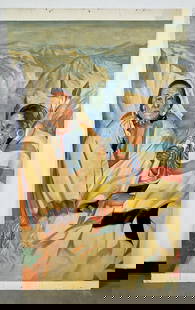
Sold2023Manner of Winold Reiss Glacier Park PaintingOil on Board. 42 1/2" by 73". Panel features two Indians smoking, the park's vast mountain range sprawls behind them. Indians featured are: Big Face Chief; Arrow Top. Provenance: Ex Stainsby CollectioSee Sold Price
Sold2023Glacier Park Mountain Goat Spelter BankGermany - Circa Late 1910's. Illustrated as #81 in PGSB.See Sold Price
SoldScott Christensen (born 1962) Glacier Park, Autumn 30 x 36 in. framed 38 x 43 in.Scott Christensen (born 1962) Glacier Park, Autumn signed 'CHRISTENSEN ©' (lower right) and signed again and titled on a label (attached to the frame wire) oil on canvas 30 x 36 in. framed 38 x 4See Sold Price
Sold2021Carved wood bear by John.Louis Clarke, MontanaCarved wood bear by John Louis Clarke, Glacier Park Montana Dimensions: 6.5"L x 4.25"W x 9.75"H John Louis Clarke (Source: theclarkegallery.com) Throughout his long life, John Louis Clarke used his haSee Sold Price
Sold2023Pablo Picasso Lithograph of The Dove 1949Picasso's image of a dove, first produced in 1949, became one of the best-known icons of international peace when it was adopted as the symbol for the First World Peace Congress organized by the CommuSee Sold Price
Sold2023WWII U.S. MILITARY FIELD MAPS 1939-1945 - (4)170301 WWII U.S. MILITARY FIELD MAPS 1939-1945 - (4) WWII U.S. military field maps 1939- 1945 to include one East and West Omaha beach scanned "Bigot" Field maps, one France (12500) Isigny field map,See Sold Price
Sold2024Pre-Central Park Map of New York City, David H. Burr / Simeon DeWitt 1829Sight size 21" x 50.5" framed to 24.75" x 54.5". Some tears and seams with attempts at repair, foxing and toning, not examined out of frame.See Sold Price
2 days LeftAntiques Online AuctionsVintage Texas 1845 Map Printed in 1986, Compiled by John DavisUS$60(4 bids)
Jun 23Treasure Quest AuctionsGreene County, NY Directory for 1896 by Fred Craigie, Catskill NY with MapUS$50


![Scheuerle pictorial map of Glacier National Park, 1930: Heading: (Montana) Author: Scheuerle, Joe Title: Great Northern Recreational Map of Glacier National Park Montana: Waterton Lakes National Park, Alberta Place Published: [St. Paul, Minnesota] Publishe](https://p1.liveauctioneers.com/642/213263/108964097_1_x.jpg?height=310&quality=70&version=1627941972)


![[NATIONAL PARKS] LINDGREN, Jolly. Hysterical Map of: [NATIONAL PARKS] LINDGREN, Jolly. Hysterical Map of Zion National Park. Spokane, WA, 1939. Comical pictorial map of the national park in Utah, showing mountain ranges, roads, and other features, with](https://p1.liveauctioneers.com/928/200564/101543211_1_x.jpg?height=310&quality=70&version=1618323144)


![[PRESS PHOTOS] LOT OF 7 SOLD TOGETHER (1 of 3)](https://p1.liveauctioneers.com/8124/329546/177689873_1_x.jpg?height=282&quality=70&version=1715469494)

