Sold20241860 Minnesota and Dacotah Territory MapHand-colored map depicting Minnesota and the un-unified Dakota territories. Parts of Wisconsin and Iowa are seen in the margins. Surrounded by a border of floral vines and ribbons. Inscribed in the maSee Sold Price
Sold2020Minnesota & DacotahTitle: Minnesota & Dacotah Description: By Augustus S. Mitchell. Hand colored engraved map. From ‘the New General Atlas’. Published in Philadelphia. Date/Period: 1862 Materials: steel engraved DimSee Sold Price
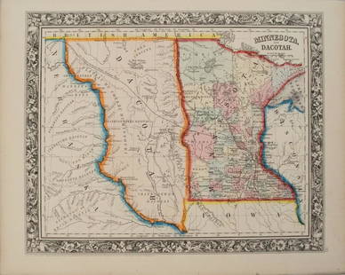
Sold20171860 Minnesota and Dacotah, S. Augustus Mitchell, Jr1860 Minnesota and Dacotah, S. Augustus Mitchell, Jr. 10.625 x 13.125 inches. Engraved map with exceptionally bright original hand-coloring. This attractive, historical map depicts the new State ofSee Sold Price
Sold20221930's Road Maps Minnesota, Oregon & Ontariorated 7 to 8, 9"x4", light wear.See Sold Price
Sold2019Minnesota, Dakota’sTitle/Content of Map: Minnesota, Dakota’s Date: 1863 Cartographer: By Johnson & Ward. From, Johnson’s New Illustrated Family Atlas Size: 18x14” Provenance: New York Additional Info: Hand coloredSee Sold Price
Sold2018Colton: Antique Map of Minnesota & Dakota, 1859Title/Content of Map: Minnesota & Dakota by Colton Date Printed: 1859 Cartographer: H.J. Colton Material/Medium: Paper Size: 17 1/4" X 15" Hand colored,engraved. Published in New York in 'Colton's GenSee Sold Price
Sold2017Colton: Antique Map of Minnesota, 1871Title/Content of Map: Minnesota by Colton Date Printed: 1871 Cartographer: G. W. Colton Material/Medium: Paper Size: 15" x 17" Hand colored lithograph. From 'Colton's American Atlas.' Published in NewSee Sold Price
Sold2017Mitchell: Antique Map of Minnesota, 1869Title/Content of Map: Minnesota by Mitchell Date Printed: 1869 Cartographer: Augustus S. Mitchell Material/Medium: Paper Size: 12" x 15" Hand colored engraved Map. From 'Mitchell's New General Atlas.'See Sold Price
Sold2023Map of Minnesota Territory by J.H. Young, 1854Map of Minnesota Territory by J.H. Young, Published by Cowperthwait, Desilver & Butler, Philadelphia, 1854. Scale 1:2,400,000 Image measures 15 1/2" x 12 1/2". Frame measures 22&quSee Sold Price
Sold2016MAP OF MINNESOTA TERRITORY BY J.H. YOUNG 1854Hand tinted lithograph map by J.H. Young, Cowperthwait, Desilver & Butler, 1854. Measures 14 x 17.2 inches overall. Depicts the Minnesota territory, lakes, rivers, forts, and native American tribal reSee Sold Price
Sold2018Early pocket map of MinnesotaHeading: Author: Colton, J.H. Title: Minnesota Place Published: New York Publisher:J.H. Colton & Co Date Published: 1855 Description: Folding color map, 12 x 15 inches. FolSee Sold Price
Sold2017Young: Map of Minnesota Territory, 1850Map: Map of Minnesota Territory Maker: J. H. Young Publisher: Cowperthwait, DeSilver & Butler Publishing Date: 1850 (1854) "Important early map of Minnesota Territory, including all of Dakota, from thSee Sold Price
Sold20201855 Colton Map of Minnesota and the Dakotas --Title: 1855 Colton Map of Minnesota and the Dakotas -- Minnesota Cartographer: J Colton Year/Place: 1855, New York Size: 11.8 X 15.7 in. Description: This is an excellent map of Minnesota and the emerSee Sold Price
Sold20191855 Colton Map of Minnesota and the Dakotas --Reserve Reduced! Title/Content of Map: 1855 Colton Map of Minnesota and the Dakotas -- Minnesota Date: 1855, New York Cartographer: J Colton Size: 11.8 X 15.7 in. This is an excellent map of MinnesotaSee Sold Price
Sold20201858 Map of Minnesota and DakotaAuthor: Johnson Title: 1858 Map of Minnesota and Dakota Medium: Ink on Paper Dimensions: 18"X14.5" Map of Minnesota and Dakota dated 1858. Engraved by A.J. Johnson. Published by Johnson and Ward in NeSee Sold Price
Sold20211867 Colton Map of Minnesota -- MinnesotaTitle: 1867 Colton Map of Minnesota -- Minnesota Cartographer: G & C Colton Year / Place: 1867, New York Map Dimension (in.): 23.3 X 16.8 in. This is an excellent doubble page map of Minnesota. The noSee Sold Price
Sold20201860 Mitchell Map of Minnesota and the DakotasTitle/Content of Map: 1860 Mitchell Map of Minnesota and the Dakotas --Minnesota and Dacotah Date: 1860, Philadelphia Cartographer: S Mitchell Size: 10.6 X 13.3 in. This is a rather nice map of MinnesSee Sold Price
Sold2022County Map of Minnesota from S. A. Mitchell, Jr. (1874)Fully hand colored map of Minnesota divided into counties. Towns, capitols, roads, rivers, lakes, railroads, and proposed railroads are labeled. A wagon road from Fort Ridgely westward toward the MissSee Sold Price
Sold20191938 R Taylor White Pictorial Map of Minnesota --Title: 1938 R Taylor White Pictorial Map of Minnesota -- Minnesota Date: 1938, Boston Cartographer: Ruth Taylor White Size: 11.6 x 8.5 in. Additional Information: This is Ruth Taylor White's charmingSee Sold Price
Sold2017Colton: Antique Map of Minnesota, 1867Huge 1867 Minnesota map by Colton. Very fine example of this early large format map. Finely engraved map of the state with inset of the north-eastern portion at upper right. Highly detailed with identSee Sold Price
Sold2017Colton: Antique Map of Minnesota, 1855Extremely clean 1855 Colton map of Minnesota. From the 1856 edition of Colton’s Atlas of the World. A virtually spotless map. Lovely full hand-color and impression. Two tiny, light margin spotsSee Sold Price
Sold20191872 Asher & Adams Map of Minnesota -- Asher & Adams'Title/Content of Map: 1872 Asher & Adams Map of Minnesota -- Asher & Adams' Minnesota Date: 1872, New York Cartographer: Asher & Adams Size: 22.4 x 16.1 in. This is a fantastic, very large double pageSee Sold Price
Sold2021Nice 1862 map of Minnesota by MitchellMap of Minnesota at the time of the Dakota War of 1862. In August of that year, along the Minnesota River in the southwestern part of the state, the Dakota tribe began attacking settlers due to the haSee Sold Price
Jun 14DuMouchellesWilliam H. Gamble (American, B. 1863) Hand Colored Engraving, Ca. 1863, "County Map of Michigan AndUS$50(1 bid)
10 hrs LeftFreeman's | Hindman[MAP]. TODESCHI, Pietro. [Nova et Acurata Totius Americae Tabula auct. G.I. Blaeu] America quartaUS$5,000
10 hrs LeftFreeman's | Hindman[MAP]. ORTELIUS, Abraham. Americae Sive Novi Orbis, Nova Descriptio. 1573.US$1,000(1 bid)
Jun 23Schilb Antiquarian Rare Books1977 JRR Tolkien 1st ed Silmarillion Lord of the Rings Middle Earth + MAPUS$155(7 bids)
2 days LeftEarly American History Auctions1720 Colonial Northumberland County Virginia Manuscript Deed and Map PlotUS$400
10 hrs LeftFreeman's | Hindman[MAP]. ORTELIUS, Abraham. Turcici Imperii Descriptio.1592.US$225(2 bids)
10 hrs LeftFreeman's | Hindman[MAP]. SPEED, John. A New Mappe of the Romane Empire. 1676.US$200(1 bid)
Jun 18DOYLE Auctioneers & AppraisersSet of Twelve Satirical Anthropomorphic Maps of EuropeUS$400(1 bid)
Jun 23Schilb Antiquarian Rare Books1890 Livingstone 1ed In Darkest Africa Henry Stanley Emin Pasha Expedition MAPUS$115(8 bids)
Jun 23Schilb Antiquarian Rare Books1848 Emory Military Reconnaissance 1ed California MAP Indians Texas New MexicoUS$3(3 bids)
3 days LeftThe North Georgia Auction Company LLCClint Alderman Edgefield Area Potteries MapUS$200(1 bid)
11 hrs LeftHolabird Western Americana CollectionsSanitary & Topographical "Viele Map" of Manhattan 1865 [182838]US$750


![[MAP]. TODESCHI, Pietro. [Nova et Acurata Totius Americae Tabula auct. G.I. Blaeu] America quarta (1 of 1)](https://p1.liveauctioneers.com/197/329395/177650542_1_x.jpg?height=282&quality=70&version=1715364962)
![[MAP]. ORTELIUS, Abraham. Americae Sive Novi Orbis, Nova Descriptio. 1573. (1 of 2)](https://p1.liveauctioneers.com/197/329395/177650534_1_x.jpg?height=282&quality=70&version=1715364962)


![[MAP]. ORTELIUS, Abraham. Turcici Imperii Descriptio.1592. (1 of 2)](https://p1.liveauctioneers.com/197/329395/177650538_1_x.jpg?height=282&quality=70&version=1715364962)
![[MAP]. SPEED, John. A New Mappe of the Romane Empire. 1676. (1 of 2)](https://p1.liveauctioneers.com/197/329395/177650541_1_x.jpg?height=282&quality=70&version=1715364962)


![Sanitary & Topographical "Viele Map" of Manhattan 1865 [182838] (1 of 3)](https://p1.liveauctioneers.com/2699/331495/178785766_1_x.jpg?height=282&quality=70&version=1717094933)
![[MAP]. ORTELIUS, Abraham. Romani Imperii Imago. 1592. (1 of 2)](https://p1.liveauctioneers.com/197/329395/177650537_1_x.jpg?height=282&quality=70&version=1715364962)