Sold2015Map of Proposed Southern Ute Indian Res. in Utah 1888Map of the Proposed Southern Ute Indian Reservation in Utah 1888. Section 4 of Act of May 1, 1888. Washington D.C. Bell Brothers, Drawn by I.P. Berthong. Note 50th Congress, 2 nd Session, Senate ExecuSee Sold Price
Sold2022[MANUSCRIPT MAP-FLORIDA & MISSISSIPPI RIVER] Map Showing Raiford's Proposed Artificial River and[MANUSCRIPT MAP-FLORIDA & MISSISSIPPI RIVER] Map Showing Raiford's Proposed Artificial River and Plan to Continue the Western and Southern Inland System of Navigation to Harbors in the Atlantic. [FernSee Sold Price
Sold2024Dennis Phillips (1938- ), Southern Utah LandscapeDennis Phillips (1938- ) Southern Utah Landscape Medium: oil on board Dimensions: 32 x 36 Framed/base dimensions: 36 3/4 x 30 3/4 x 1 3/4 Signature: signed lower right: Dennis Phillips verso: titled PSee Sold Price
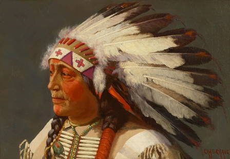
Sold2021CHARLES CRAIG (1846-1931)Charles Craig (1846-1931) Ute Indian Chief signed 'Chas. Craig' (lower right) oil on canvas 18 x 26in framed 27 x 35in Painted circa 1881. Footnotes: Provenance Sale, Heritage Auction,See Sold Price
Sold2018Antique Indian Polychrome Wood Figurine18/19th cen, southern indian, was mounted as a lamp, losses of pigment, split of wood consitent with age, measures 26" in height; Provenace: from a Prominent Chicago EstateSee Sold Price
20191708 Cellarius Celestial Map from Southern HemisphereTitle: 1708 Cellarius Celestial Map from Southern Hemisphere -- Haemisphaerium Scenographicum Australe Coeli Stellati et Terrae Date: 1708, Amsterdam Cartographer: A Cellarius Size: 16.8 X 19.1 in. AdSee Sold Price
Sold2018South East Asia.- Ortelius (Abraham) Indiae OrientalisSouth East Asia.- Ortelius (Abraham) Indiae Orientalis Insularumque Adiacientium Typus, map of southern Asia from India across to Java and New Guinea, and including China and Japan to the north, withSee Sold Price
Sold2022Rare Antique Mayo Indian Blanket Southern Sonora/Northern Sinaloa Last Quarter 19th CenturyRare Antique Mayo Indian blanket Southern Sonora/northern Sinaloa, Last Quarter19th Century. It resembles an old Rio Grande blanket. The Mayo weavers were using indigo dyes as late as 1970. This itemSee Sold Price
Sold2021Colton’s map of the Southern States.Title: Coltonâ€â„¢s map of the Southern States. Publication Date: 1861 Cartographer: J. Calvin Smith Publisher: Joseph Hutchins Colton Description: Including Maryland, Delaware, Virginia, KenSee Sold Price
Sold2023Laurie & Whittle Map of the Southern British Colonies of AmericaLAURIE, Robert (1755-1836), and WHITTLE, James (1757-1818). A New and General Map of the Southern Dominions belonging to the United States of America... Engraved map with original hand color in outlinSee Sold Price
Sold2015Antique Gilt Bronze BuddhaGilt bronze Buddha standing 6 1/2" in overall height, possibly Southern Asia or Indian. Shipping: We are able to pack and ship this item to an address in the United States for $40.00 via USPS PrioritySee Sold Price
Sold20221755 Map of North America by De VaugondyHistoric Maps 1755 French & Indian War Era Map of North America by De Vaugondy 1755-Dated French & Indian War Era, Large Hand-Colored Map titled, "PARTIE DE L'AMERIQUE SEPTENTRIONALE, QUI COMPREND LESee Sold Price
Sold2022Colom's Map of the Western Indian Ocean, c. 1658COLOM, Arnold (1624-1668). Oost Indien van Cabo de Bona Esperanca tot Ceilon. Engraved map with original hand color in outline. Amsterdam, c. 1658. 22 1/4" x 25 1/2" sheet. Colom's Zee Atlas is amongSee Sold Price
Sold2022MACLEOD, Alexander Samuel (1888-1956). A Map of Honolulu an...MACLEOD, Alexander Samuel (1888-1956). A Map of Honolulu and the Sandwich Islands which we now call the Hawaiian Islands. 1927. New York: Henry M. Snyder. Scarce and detailed map of Honolulu, with anSee Sold Price
Sold2021Bancroft's California, Nevada, etc. 1864Heading: Author: Bancroft, Hubert Howe Title: Bancroft's Map of California, Nevada, Utah and Arizona Place Published: San Francisco Publisher:H.H. Bancroft & Company Date Published: 1864See Sold Price
Sold2021Bancroft's Map of California, Nevada, 1873Heading: Author: Bancroft, Albert Little Title: Bancroft's Map of California, Nevada, Utah and Arizona, Published by A. L. Bancroft & Compy. Booksellers & Stationers San Francisco Cal. 1873 Place PubSee Sold Price
Sold2021Framed 1822 French map of IndianaFramed 1822 French map of Indiana, shows Indian territories and 35 of the 92 counties, but it's in French! 25.5"H x 32"W overall in contemporary frameSee Sold Price
Sold2023RARE Cheyenne Quilled & Beaded War Shirt Ca. 1875This is an astounding, rare and authentic circa 1875 hide painted war shirt with quillwork and beadwork from the Southern Cheyenne Native American Indians. This is truly a masterpiece of American IndiSee Sold Price
Sold2022C. 1870 Southern Cheyenne Beaded Pipe Bag RAREThis is an exceptional, rare, and highly collectible circa 1870 beaded pipe bag from the Southern Cheyenne Native American Indians of the Southern Plains and from the DuPont family collection. The pipSee Sold Price
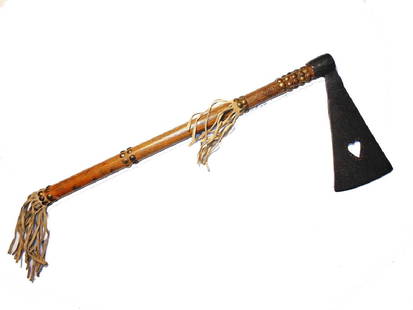
Sold2017Southern Plains War Tomahawk circa 1870This is a wonderful authentic Tomahawk War Club from the Southern Plains Native American Indians. The piece was collected from the Apache tribe at San Carlos, with collection information accompanyingSee Sold Price
Sold2017French and Indian War, Thomas Jefferys' Broadside MapJefferys, Thomas. North America From the French of Mr D'Anville Improved with the Back Settlements of Virginia and Course of Ohio Illustrated with Geographical and Historical Remarks. London: 1755. CoSee Sold Price
Sold2021Frederic Kimball Mizen (American, 1888-1964) PortraitFrederic Kimball Mizen (American, 1888-1964) Portrait of an Indian Man gouache on board signed Frederic Mizen (lower right) 19 1/2 x 15 inches Property from the Collection of Michael Cole, MarylandSee Sold Price
5 days LeftJasper52Farther India. Indochina Siam Burma Shan States Anam. BARTHOLOMEW 1888 old mapUS$25
Featured4 days LeftJasper52Johnson's New Military Map of the United States Showing the Forts, Military Posts &C. With EnlargedUS$65
Jun 23Schilb Antiquarian Rare Books1848 Emory Military Reconnaissance 1ed California MAP Indians Texas New MexicoUS$1
35 mins LeftAlbion AuctionsNat. Encyclo. 1890's Pair of Celestial Maps. Northern & Southern ConstellationsUS$25(4 bids)
Jun 12Dan Morphy AuctionsPLATE CXIII. MAP OF INDIAN TERRITORY SHOWING DISTRIBUTION OF WOODLAND” FROM THE TWENTY-FIRSTUS$100
Jun 07Freeman's | HindmanBELLIN, Jacques-Nicolas. Carte Reduite de L'Ocean Oriental ou Mer Des Indies. Paris, 1757. SecondUS$150
Jun 12Dan Morphy AuctionsMAP OF THE CHOCTAW NATION, INDIAN TERRITORY - COAL AND ASPHALT SEGREGATION 1903US$150
Jun 12Dan Morphy AuctionsMAP OF THE CHOCTAW NATION, INDIAN TERRITORY - COAL AND ASPHALT SEGREGATION 1903US$100
Jun 05Lion Heart AutographsRare ALS by American Indian Artist Allan Houser: “I am an Apache...taken as prisoners of warUS$200


![[MANUSCRIPT MAP-FLORIDA & MISSISSIPPI RIVER] Map Showing Raiford's Proposed Artificial River and: [MANUSCRIPT MAP-FLORIDA & MISSISSIPPI RIVER] Map Showing Raiford's Proposed Artificial River and Plan to Continue the Western and Southern Inland System of Navigation to Harbors in the Atlantic. [Fern](https://p1.liveauctioneers.com/292/250642/130213644_1_x.jpg?height=310&quality=70&version=1654271664)