Sold2021Map of Prussia Including Also the German Empire.Title: Map of Prussia Including Also the German Empire. Cartographer: DOWER, JOHN] Publication Date: 1875 Publisher: H. H. HARDESTY & CO. Height: 19 Width: 14.75 Very detailed. Some topography. Map reSee Sold Price
Sold2017Mitchell: Map of the Austrian Empire, 1879Map of Prussia and the German States. Map of the Austrian Empire, Italian States. Turkey in Europe and Greece. Maltese Islands. Mitchell, Samuel Augustus Jr. 1880. Two maps on either side of the sheetSee Sold Price
Sold20191759 Delarochette Map of the German Empire and most ofTitle/Content of Map: 1759 Delarochette Map of the German Empire and most of Central Europe -- Map of the Empire of Germany, Including All the States Comprehended under that Name: with the Kingdom ofSee Sold Price
Sold2023Smollett, Tobias 1761 Map. Seat of War, Empire of Germany"An Accurate Map of the seat of War in the Empire of Germany as also in the Kingdom of Prussia" Copper Engraved Map Published 1757-65, London for "A Complete History of England" by Tobias George SmollSee Sold Price
Sold2023WWI GERMAN EMPIRE 1870 GRAND CROSS OF THE IRON CROSSA German 1870 Star of the Grand Cross of the Iron Cross, also known as the Grand Cross of the Iron Cross, a prestigious military decoration in the Kingdom of Prussia and later the German Empire. It waSee Sold Price
Sold2023GERMAN IMPERIAL 1870 GRAND CROSS OF THE IRON CROSSA German 1870 Star of the Grand Cross of the Iron Cross, also known as the Grand Cross of the Iron Cross, a prestigious military decoration in the Kingdom of Prussia and later the German Empire. It waSee Sold Price
Sold2022Large Antique French map GERMAN EMPIRE 1792 colored by POIRSON engraver BassetJean-Baptiste Poirson is an engineer-geographer and cartographer. Born in Vrécourt (Vosges) on March 6, 1761, he studied mathematics, geography and followed an engineering career. Under the direcSee Sold Price
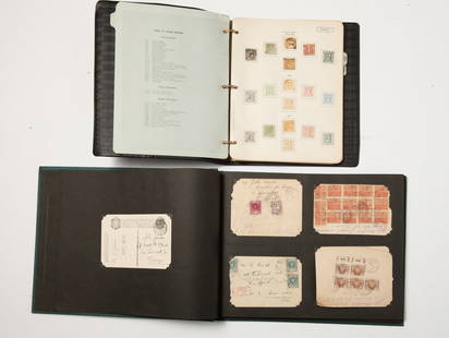
Sold2024Germany. and States 1880-1989 #37/#2776 Stamp Collection.Germany. and States 1880-1989 #37/#2776 Stamp Collection. A broad collection including German Empire, officials of the Republic, German occupation stamps, Barvaria, Danzig, Werttemberg (Some nice earlSee Sold Price
Sold2017Map of German Empire East Sheet, 1885Map: German Empire East Sheet German Empire East Sheet From Black's General Atlas of the World New and Revised Edition. Edinburgh 1885 Size: 12.25 x 17.25 inches No Reserve: This lot starts at $1 andSee Sold Price
Sold2016Map of German Empire 1788Heading: Author: Dezauche, J.A. Title: L'Allemagne dressee sur les Observations de Tycho Brahe de Kapler de Suellius… Place Published: Paris Publisher: Date Published: 1788 DescriptionSee Sold Price
Sold2019Map of Prussia & German StatesHeading: (Maps) Author: Mitchell, Samuel Augustus Title: Prussia and the German States Place Published: Philadelphia Publisher: Date Published: c.1870 Description: LitographSee Sold Price
Sold20231932 EAGLE LINE NATIONAL BINDER of GERMAN STAMPSIncluding: 1862 German Empire, 1852 Thurn and Taxis, German Republic, etc. Together with a photo album with early cancelled air mail European, African and South American stamps on their envelopesSee Sold Price
Sold2022WW I Books & MapWW I Books and Map, including: one German, including one German, Zeppeline Uber England, 1917, Der Wall von Eifen and Feuer ein Jahran der (The Wall of Tires and Fire for a year on the Western Front)See Sold Price
Sold2020Maps C1850-1908 Mixed Lot of 7 MapsMixed Lot of Engraved and Lithographed Maps. Incl German Empire, Europe, Canaan/Palestine, Central Europe, Zoological Regions of the World and British Isles. Examples by Stanford/Medland, Weller, GoldSee Sold Price
Sold2018Maps C1800-C1940 Mixed Lot of 16Mixed lot on Lithograph and Engraved Maps. Incl German Empire, West Indies, Ireland, Asia, Switzerland, France, South Atlantic, Africa, World and Paris. Examples by SDUK, ILN, Bartholomew/Philip, LogeSee Sold Price
Sold20181743 Le Rouge Map of the German Empire -- L'EmpireTitle/Content of Map: 1743 Le Rouge Map of the German Empire -- L'Empire d'Allemagne de die a Monseigneur a Melot ministre a Secretaire d'Etal par le Rouge a Paris... Date: 1743, Paris Cartographer: GSee Sold Price
Sold2017Mitchell: Map of Prussia & the German States, 1864Title: Map of Prussia and the German States by Mitchell Date: 1864 Dimensions (inches): 15.2 x 12.2 Medium: Hand Colored Lithograph Condition: Good Condition Please note that this lot has a confidentiSee Sold Price
Sold2020World Coins: Mixed Estate lotLarge selection of estate-fresh World coins, 18th through 20th century including Ecuador, German Prussian Empire, Italy, Jamaica, Netherlands, India, Chile, and many more. Some Silver as-found. DatesSee Sold Price
Sold2023Important Prussian Presentation Sword "Officer Feld Art. Regt. No.62", circa 1899Eastern Europe, German Empire, Prussia, circa 1899s. Important Presentation saber for the Prussian Field Artillery Officer Regiment No.62 (Established March 25th of 1899, East Frisian, stationed in OlSee Sold Price
Sold2023WWI GERMAN EMPIRE 1914 STAR GRAND CROSS OF IRON CROSSA Star of the Grand Cross of the Iron Cross 1914 is the highest military award of the Kingdom of Prussia and the German Empire. The Grand Cross star was intended for the most outstanding generals whoSee Sold Price
Sold2021Collection of Antique Maps of North AmericaA framed collection of nine small maps including "The English Empire in America, Newfound-Land, Canada, Hudsons Bay &c. in Plano" by Herman Moll circa 1709 and "North America from the Best AuthoritiesSee Sold Price
Sold2022(2) EARLY 20TH C. POCKET WALKING MAPS OF PARISEarly 20th century visitor guides with itinerary suggestions, listing of all sites and streets, also including maps. Dimensions: (Larger) H 5.75" x W 4" x D 1" Condition: Wear and tear throughout consSee Sold Price
Sold20231910 Rand McNally Map of Austria-Hungary [verso] German Empire -- Austria-Hungary [verso] GermanTitle: 1910 Rand McNally Map of Austria-Hungary [verso] German Empire -- Austria-Hungary [verso] German Empire Cartographer: Rand McNally Year / Place: 1910, Chicago Map Dimension (in.): 9.2 X 13 in.See Sold Price
Sold2022Antique Map Print - France - Belgium - German Empire - GreeceSet of 4 Map Prints. Antique lithographic map originates from "Letts's Popular Atlas", being a series of maps delineating the whole surface of the globe, with many special and original features; and aSee Sold Price
1 day LeftJasper521914 Rand McNally Map of Austria-Hungary [verso] German Empire -- Austria-Hungary [verso] GermanUS$30
1 day LeftJasper521869 Mitchell Map of Much of Western Europe -- XXXII Prussia the German States Holland & BelgiumUS$30
2 days LeftJasper52Europe. Royaume des Pays-Bas #13 NW Europe Benelux Germany VANDERMAELEN 1827 mapUS$50
Jun 02Schilb Antiquarian Rare Books1897 History of British Empire England Scotland Canada James II MAPS India 6vUS$2(2 bids)
1 day LeftJasper521894 Johnston Map of Oceania [verso] Island in the Indian Ocean and Near Africa -- Oceania [verso]US$40
2 days LeftJasper52EUROPE. Austrian Empire Prussia Poland. Slave market pic. RAPKIN/TALLIS 1851 mapUS$100
2 days LeftJasper52EUROPE. Austrian Empire Prussia Poland. Slave market pic. RAPKIN/TALLIS 1851 mapUS$100
May 31Freeman's | Hindman[CIVIL WAR]. Archive of items related to Elisha Hunt RHODES (1842-1917), 2nd Rhode Island VolunteerUS$750
19 hrs LeftAkiba Galleries(2 Pc) Allain Manesson Mallet Description De L'Univers 2 Vol. German TranslationUS$200(1 bid)
2 days LeftJasper52L'Allemagne, La Boheme, et La Hongrie; avec…partie de Pologne. BONNE 1780 mapUS$60
1 day LeftJasper521869 Mitchell Map of South-Central Europe [verso] Asia -- XXXIV Austria, Switzerland, Italy, TurkeyUS$30
2 days LeftJasper52Les Royaumes de Suede et Norwege…. Scandinavia. SANTINI / JANVIER 1784 mapUS$100
2 days LeftJasper52Northern States of Europe… Denmark Norway Sweden Russia Prussia. PAAS 1800 mapUS$70


![Map of Prussia Including Also the German Empire.: Title: Map of Prussia Including Also the German Empire. Cartographer: DOWER, JOHN] Publication Date: 1875 Publisher: H. H. HARDESTY & CO. Height: 19 Width: 14.75 Very detailed. Some topography. Map re](https://p1.liveauctioneers.com/5584/223691/115294050_1_x.jpg?height=310&quality=70&version=1635887230)


![1910 Rand McNally Map of Austria-Hungary [verso] German Empire -- Austria-Hungary [verso] German: Title: 1910 Rand McNally Map of Austria-Hungary [verso] German Empire -- Austria-Hungary [verso] German Empire Cartographer: Rand McNally Year / Place: 1910, Chicago Map Dimension (in.): 9.2 X 13 in.](https://p1.liveauctioneers.com/5584/292843/155324654_1_x.jpg?height=310&quality=70&version=1687296978)

![1914 Rand McNally Map of Austria-Hungary [verso] German Empire -- Austria-Hungary [verso] German (1 of 2)](https://p1.liveauctioneers.com/5584/328338/176911532_1_x.jpg?height=282&quality=70&version=1715113718)


![1894 Johnston Map of Oceania [verso] Island in the Indian Ocean and Near Africa -- Oceania [verso] (1 of 2)](https://p1.liveauctioneers.com/5584/328338/176911535_1_x.jpg?height=282&quality=70&version=1715113718)


![[CIVIL WAR]. Archive of items related to Elisha Hunt RHODES (1842-1917), 2nd Rhode Island Volunteer (1 of 6)](https://p1.liveauctioneers.com/197/329785/177758366_1_x.jpg?height=282&quality=70&version=1715625218)


![1869 Mitchell Map of South-Central Europe [verso] Asia -- XXXIV Austria, Switzerland, Italy, Turkey (1 of 2)](https://p1.liveauctioneers.com/5584/328338/176911683_1_x.jpg?height=282&quality=70&version=1715113718)


