Sold2021Two Early Maps of the Texas RepublicTwo Early Maps of the Texas Republic each engraved with hand-coloring, the first by T. G. Bradford, engraved by G. W. Boynton, published Boston, 1838; the second by C. S. Williams, from A New UniversaSee Sold Price
Sold20164 Maps: Bradford (1838): Mass., CT, NJ, Boston.[United States/Northeast] 4 Maps. ++ MASSACHUSETTS. ++ BOSTON. ++ CONNECTICUT. ++ NEW JERSEY. ++ Maps 10, 11, 13, and 16 from T. G. Bradford, “An Illustrated Atlas, Geographical, Statistical, And HiSee Sold Price
Sold20174 TN Maps, Bradford, 1835, 1838, & 18411st item: "Tennessee" Map, by Thomas G. Bradford, engraved by George W. Boynton, published by William D. Ticknor, Boston, 1835. From "A Comprehensive Atlas, Geographical, Historical & Commercial" by TSee Sold Price
Sold20211838 Bradford Map of Indiana -- IndianaTitle: 1838 Bradford Map of Indiana -- Indiana Cartographer: T Bradford Year / Place: 1838 Boston Map Dimension (in.): 14.2 x 11 in. This is a nice and highly detailed state map. The counties are coloSee Sold Price
Sold2016(4) 1838 BRADFORD Maps: NC, SC, GA, FL.[United States/South] 4 Maps. ++ NORTH CAROLINA. ++ SOUTH CAROLINA. ++ GEORGIA. ++ FLORIDA. ++ +Maps 28, 30, 31, 32 from T. G. Bradford, “An Illustrated Atlas, Geographical, Statistical, And HistoriSee Sold Price
Sold2016(4) 1838 BRADFORD Maps: OH, IN, MI, TN[United States/Near West] 4 Maps. ++ OHIO. ++ INDIANA. ++ MICHIGAN. [With inset of upper peninsula.] ++ TENNESSEE. ++ Maps 19, 20, 22, 29 from T. G. Bradford, “An Illustrated Atlas, Geographical, StSee Sold Price
Sold2018Bradford: Antique Map of Iowa and Wisconsin, 1838Title/Content of Map: 1838 Bradford Map of Iowa and Wisconsin -- Iowa and Wisconsin Date Printed: 1838, New York Cartographer: T Bradford Size: 14.3 x 11.5 in. This is a rather scarce early map of porSee Sold Price
Sold2017Bradford: Antique Map of the West Indies, 1838Title/Content of Map: Bradford's West Indes Date Printed: 1838/1841 Cartographer: Thomas G. Bradford Material/Medium: Paper Size: 16 3/4" x 13 1/4" Hand colored. A General Atlas of the World with a SeSee Sold Price
Sold2020Map of Republic of Texas & Mexico 1838Heading: (Texas) Author: Niles, J.M. & L.T. Pease Title: A Map of Mexico and the Republic of Texas. Drawn & Engraved to accompany the History of Mexico & Texas by J.M. Niles & L.T. Pease, 1838 Place PSee Sold Price
Sold20211838 Thomas Bradford Atlas Map of MichiganAtlas map of Michigan showing then current counties, towns, etc. Hand colored borders. Along the bottom margin: “Entered according to Act of Congress in the year 1838 by T.G. Bradford in the ClerksSee Sold Price
2021Bradford's Map of Texas 1835/36"Bradford's Map of Texas, 1st Separate Map of Texas to Appear in an Atlas" by Thomas G. Bradford, copper engraving with hand-colored outlines, published Boston, 1835/1836, together with accompanying aSee Sold Price
Sold2017Bradford: Antique Map of Louisiana, 1838Title/Content of Map: Louisiana by Bradford Date Printed: 1838/1841 Cartographer: Thomas G. Bradford Material/Medium: Paper Size: 16 1/2" x 13" Hand colored. A General Atlas of the World with a SeparaSee Sold Price
Sold2017Bradford: Antique Map of Kentucky, 1838Title/Content of Map: Kentucky by Bradford Date Printed: 1838/1841 Cartographer: Thomas G. Bradford Material/Medium: Paper Size: 16 1/2" x 13" Hand colored. A General Atlas of the World with a SeparatSee Sold Price
Sold2017Bradford: Antique Map of Pennsylvania, 1838Title/Content of Map: Pennsylvania by Bradford Date Printed: 1838/1841 Cartographer: Thomas G. Bradford Material/Medium: Paper Size: 16 1/2" x 13" Hand colored. A General Atlas of the World with a SepSee Sold Price
Sold2017Bradford: Antique Map of Massachusets, 1838Title/Content of Map: Massachusets by Bradford Date Printed: 1838/1841 Cartographer: Thomas G. Bradford Material/Medium: Paper Size: 13" x 16 1/2" Hand colored. A General Atlas of the World with a SepSee Sold Price
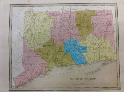
2017Bradford: Antique Map of Conneticut, 1838Title/Content of Map: Conneticut by Bradford Date Printed: 1838/1841 Cartographer: Thomas G. Bradford Material/Medium: Paper Size: 13" x 16 1/2" Hand colored. A General Atlas of the World with a SeparSee Sold Price
Sold2017Bradford: Antique Map of Texas, 1841Item: Map of Texas Maker: Thomas J. Bradford Date: 1841 Matted Size: With matte measures 18 1/2" x 15 3/4" Please note that this lot has a confidential reserve. When you leave a bid in advance of theSee Sold Price
Sold2017Bradford: Antique Map of New Hampshire, 1838Title/Content of Map: New Hampshire by Bradford Date Printed: 1838/1841 Cartographer: Thomas G. Bradford Material/Medium: Paper Size: 13" x 16 1/2" Hand colored. A General Atlas of the World with a SeSee Sold Price
Sold2017Bradford: Antique Map of Ohio, 1838Title/Content of Map: Ohio by Bradford Date Printed: 1838/1841 Cartographer: Thomas G. Bradford Material/Medium: Paper Size: 13" x 16 1/2" Hand colored. A General Atlas of the World with a Separate MaSee Sold Price
Sold2017Bradford: Antique Map of Philadelphia, 1838Title/Content of Map: Philadelphia b Bradford Date Printed: 1838/41 Cartographer: Thomas G. Bradford Material/Medium: Paper Size: 13" x 16 3/4" Condition: Excellent Hand colored. A General Atlas of thSee Sold Price
Sold2017Bradford: Antique Map of Maine, 1838Title/Content of Map: Maine by Bradford Date Printed: 1838/1841 Cartographer: Thomas G. Bradford Material/Medium: Paper Size: 13" x 16 1/2" Hand colored. A General Atlas of the World with a Separate MSee Sold Price
Sold2017Bradford: Antique Map of Tennessee, 1838Title/Content of Map: Tennessee by Bradford Date Printed: 1838/1841 Cartographer: Thomas G. Bradford Material/Medium: Paper Size: 13" x 16 1/2" Hand colored. A General Atlas of the World with a SeparaSee Sold Price
Sold2017Bradford: Antique Map of Philadelphia, 1838Title/Content of Map: Philadelphia by Bradford Date Printed: 1838/1841 Cartographer: Thomas G. Bradford Material/Medium: Paper Size: 16 3/4" x 13" Hand colored. A General Atlas of the World with a sepSee Sold Price
Sold2017Bradford: Antique Map of Arkansas, 1838Title/Content of Map: Arkansas by Bradford Date Printed: 1838/1841 Cartographer: Thomas G. Bradford Material/Medium: Paper Size: 13" x 16 1/2" Hand colored. A General Atlas of the World with a SeparatSee Sold Price
Jun 23Schilb Antiquarian Rare Books1848 Emory Military Reconnaissance 1ed California MAP Indians Texas New MexicoUS$2(2 bids)
Jun 08Simpson Galleries, LLC.JULIUS BIEN (1826-1909) AN AMERICAN CIVIL WAR RECONNAISSANCE MAP, "Map of Texas and Part of NewUS$100
Jun 12Dan Morphy AuctionsBRUE'S MONUMENTAL WALL MAP OF TEXAS, UPPER CALIFORNIA & MEXICO, C. 1845US$500
3 hrs LeftAntiques Online AuctionsVintage Texas 1845 Map Printed in 1986, Compiled by John DavisUS$60(4 bids)
Jun 12Dan Morphy AuctionsPHELPS’S TRAVELERS GUIDE THROUGH THE UNITED STATES; CONTAINING UPWARDS OF SEVEN HUNDREDUS$1,000
Jun 12Dan Morphy AuctionsGEOLOGY OF THE BLACK AND GRAND RAPIDS OF TEXAS INCLUDING THE EASTERN AND WESTERN CROSS TIMBERS,US$100
BonhamsMITCHELL (SAMUEL AUGUSTUS) A New Universal Atlas Containing Maps of the Various Empires, Kingdom...£1,300
Jun 08Simpson Galleries, LLC.J.H. Young (1792-1870) AN AMERICAN FEDERAL PERIOD MAP, "Mitchell's Travellers Guide Through theUS$500


![[Map of Texas, Bradford, 1838] First Image](https://p1.liveauctioneers.com/3532/95081/48483434_1_x.jpg?height=300&quality=1&version=1476656219&width=300)
![[Map of Texas, Bradford, 1838] First Image](https://p1.liveauctioneers.com/3532/95081/48483434_1_x.jpg?height=300&quality=95&version=1476656219&width=300)
![4 Maps: Bradford (1838): Mass., CT, NJ, Boston.: [United States/Northeast] 4 Maps. ++ MASSACHUSETTS. ++ BOSTON. ++ CONNECTICUT. ++ NEW JERSEY. ++ Maps 10, 11, 13, and 16 from T. G. Bradford, “An Illustrated Atlas, Geographical, Statistical, And Hi](https://p1.liveauctioneers.com/179/85723/44107996_1_x.jpg?height=310&quality=70&version=1457209040)


![(4) 1838 BRADFORD Maps: NC, SC, GA, FL.: [United States/South] 4 Maps. ++ NORTH CAROLINA. ++ SOUTH CAROLINA. ++ GEORGIA. ++ FLORIDA. ++ +Maps 28, 30, 31, 32 from T. G. Bradford, “An Illustrated Atlas, Geographical, Statistical, And Histori](https://p1.liveauctioneers.com/179/85723/44107998_1_x.jpg?height=310&quality=70&version=1457209205)
![(4) 1838 BRADFORD Maps: OH, IN, MI, TN: [United States/Near West] 4 Maps. ++ OHIO. ++ INDIANA. ++ MICHIGAN. [With inset of upper peninsula.] ++ TENNESSEE. ++ Maps 19, 20, 22, 29 from T. G. Bradford, “An Illustrated Atlas, Geographical, St](https://p1.liveauctioneers.com/179/85723/44107994_1_x.jpg?height=310&quality=70&version=1457208874)