Sold2024A scarce and very large plan of Montreal[MAP-CANADA] ADAMS, JOHN, surveyor. Map of the City and Suburbs of Montreal ... Constructed from a New Survey, 1825 by John Adams. New York: Engraved by J. D. Stout, 1825. Engraved map on three largeSee Sold Price
Sold2020City & Vicinity of New Haven, CT US Coast SurveyMap of the city of New Haven. City Engineers Department 1877. paper size: H 30", W 24"; frame size: H 27", W 33-1/4". Professionally framed. Collection of Laura Mitler. Please see link for high res phSee Sold Price
Sold2020Bradford Map of New York City 1/170Heading: (New York) Author: Andrews, William Loring Title: James Lyne's Survey Or, as It is More Commonly Known the Bradford Map: a Plan of the City of New York at the Time of the Granting of the MontSee Sold Price
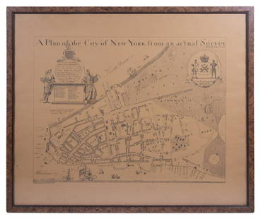
Sold2023REPLICA OF LAING'S MAP OF MANHATTAN"A Plan of the City of New York from an actual Survey" for His Excellency John Montgomerie, by William Bradford, printed on tan paper, in a faux tortoiseshell frame, under glass, 23" x 26", good condiSee Sold Price
Sold202019th C. Plan of the city of New York from an actual19th C. - A plan of the city of New York from an actual survey Known as the Bradford Plan. By James Lyne and Publisher:New-York : Pubed. by G. Hayward. Notes: Facsimile of an original map [New York :See Sold Price
Sold2022Bristol.- New History, Survey and Description of the City and Suburbs of Bristol (The), firstBristol.- New History, Survey and Description of the City and Suburbs of Bristol (The), first edition, folding engraved map, Bristol, Printed, Published and Sold by W. Matthews, 1794; bound with MatthSee Sold Price
Sold2016Official Maps of New YorkNumerous color maps of all areas of New York State. 128 pages. Publisher National Survey Company Dated: Circa 1925 Demensions: 8vo Provenance: Property of a New York City Gentleman ConditionSee Sold Price
Sold2021Map, City of New York 1824Map of the City of New York 1824. Map of Property in the Estate of Teunis Tiebout .See Sold Price
Sold2016Advertising Sunoco Map and NY Subway GuideVintage New England road map with Sunoco advertising and a New York Subway Systems and Elevated Lines map (City of New York), an advertising piece for The New York Telephone Company, "War's on the WirSee Sold Price
Sold2021Very scarce NYC & Brooklyn by W. Williams, 1847Title: Very scarce NYC & Brooklyn by W. Williams, 1847 Description: Extremely scarce map “Cities of New-York and Brooklyn, &c.&c.,” drawn and engraved by W. Williams and published in 1847. This isSee Sold Price
Sold2017Mitchell: Map of City of New York, 1849An original steel engraved map of New York City published by Augustus Mitchell in 1849, with original hand coloring. Manhattan from about 37th St with Brooklyn and Williamsburg. Key to public buildingSee Sold Price
Sold20171865 Colton New York City Map1865 Colton New York City Map -- New York City Brooklyn, Jersey City, Hoboken, Etc. C. B. Colton 1865 New York 24 x 17 in. This nice map of New York City, including Manhattan, Brooklyn, Jersey City anSee Sold Price
Sold20181827 Map Of New York CityEarly map of New York City. "NEW MAP of the City Of New York / Comprising all the late Improvements / COMPILED AND CORRECTED FROM AUTHENTIC DOCUMENTS....NEW YORK...1827". Folds as issued. Sight 13" xSee Sold Price
Sold2020Six Unframed MapsFive Harper's Weekly Civil War maps and a 1971 reprint of a 1759 map of City of New Orleans and rivers, together with floor plans for a six floor building.From the private collection of Roulhac ToledaSee Sold Price
Sold2017Colton: Antique Map of Louisville & New Orleans, 1861Title/Content of Map: Cities of Louisville & New Orleans Date Printed: 1861 Cartographer: J.H. Colton Material/Medium: Paper Size: 13" x 17" Hand colored, steel engraved. From 'Colton's General Atlas.See Sold Price
Sold2017Bradford: Antique Map of Early American Cities, 1835Title/Content of Map: Early American Cities: New York, Portland (MI), Boston, Providence, Baltimore, Albany, Philadelphia, Charleston, Savanna, New Orleans, St. Louis, Louisville, Nashville, CincinnatSee Sold Price
Sold20231850 NEW YORK City MAP Almanac Broadway RARE The Great Metropolis1850 NEW YORK City MAP Almanac Broadway RARE The Great Metropolis ‘The Great Metropolis’ is a 19th-century annual periodical on the state of New York. This work contains descriptions of iSee Sold Price
Sold20241850 NEW YORK City MAP Almanac Broadway RARE The Great Metropolis1850 NEW YORK City MAP Almanac Broadway RARE The Great Metropolis The Great Metropolis is a 19th-century annual periodical on the state of New York. This work contains descriptions of iconic buildingsSee Sold Price
Sold2021Map of the City of New York Prepared Expressly forPublication Date: c1854 Title: Map of the City of New York Prepared Expressly for Smith Brother's One Price Clothing Warehouse... Cartographer: COLTON, J.H. & CO. Height (inches): 9.5 Width (inches):See Sold Price
Sold20181968 Bollmann Pictorial Map of New York City -- NewTitle/Content of Map: 1968 Bollmann Pictorial Map of New York City -- New York Picture and Street Map Date Printed: 1968, Braunschweig, Germany Cartographer: H Bollmann, published by Bollmann BildkartSee Sold Price
Sold2022Antique NEW YORK CITY MAP - FramedAntique New York City Map. 28” x 16” New York City map, circa 1860, hand-colored, double matted and framed to 38 ½” x 26”.See Sold Price
Sold2023"Outline & Index Map of New York City" New York: E. Robinson Co., 1885"Outline & Index Map of New York City" New York: E. Robinson Co., 1885. From Robinson's Atlas of the City of New York: embracing all territory within its corporate limits from official records, privatSee Sold Price
Sold20211880 Gray Map of New York City -- New York City,Title: 1880 Gray Map of New York City -- New York City, Brooklyn, Jersey City, Hoboken Etc. Cartographer: O Gray Year / Place: 1880, Philadelphia Map Dimension (in.): 16.3 X 24.4 in. This is a fantastSee Sold Price
Sold20181887 Mitchell Map of New York City -- New York andTitle/Content of Map: 1887 Mitchell Map of New York City -- New York and Brooklyn Date: 1887, Philadelphia Cartographer: SS Mitchell Size: 13.5 x 21.1 in. This fascinating map of New York City area coSee Sold Price
2 days LeftJasper521867 Beers Map of New York City Area -- Map of New York and Vicinity Accompanying "Atlas of New YorkUS$200
1 day LeftRapid Estate Liquidators and Auction GalleryCoca Cola 1993 New Orleans Basketball TubeUS$25
Jul 06Case Antiques, Inc. Auctions & AppraisalsColton's Atlas of the World, 1856, in Two Volumes; plus Africa / Mahdist War MapUS$500(1 bid)
6 hrs LeftSchilb Antiquarian Rare Books1877 Geology Geography Surveys 1ed Nevada Wyoming Utah George Wheeler US West 2vUS$14(4 bids)
2 days LeftJasper521874 Holmes Plan of New York's Upper East Side -- Map of the Common Lands from 76th to 93rd StreetUS$750
4 days LeftSwann Auction Galleries(CIVIL WAR--VIRGINIA.) Robert B. Hathaway. Letter with detailed map of the possible river crossingsUS$600
4 days LeftForum AuctionsCartography.- Cary (John) A New Map of England...1821, hand-coloured engraved map, 1823 & others£50
2 days LeftJasper521850 Sacramento and San Joaquin Rivers Chart -- Chart of Suisun & Vallejo Bays with the ConfluenceUS$170
5 days LeftRail & Road Auctions1904 and 1907 Street Railway Journal Encyclopedias Volume 23 and 29US$50
5 days LeftRail & Road Auctions1902 and 1903 Street Railway Journal Encyclopedias Volume 20 and 21US$40
5 days LeftRail & Road Auctions1898 and 1900 Street Railway Journal Encyclopedias Volume 14 and 16US$40
5 days LeftRail & Road Auctions1929, 1930, and 1931 Electric Railway Journal Encyclopedias Volume 73, 74, and 75US$50(1 bid)


![A scarce and very large plan of Montreal: [MAP-CANADA] ADAMS, JOHN, surveyor. Map of the City and Suburbs of Montreal ... Constructed from a New Survey, 1825 by John Adams. New York: Engraved by J. D. Stout, 1825. Engraved map on three large](https://p1.liveauctioneers.com/292/326828/175962870_1_x.jpg?height=310&quality=70&version=1713473479)