Sold2016Map of the Holy Land - Leipzig, 1858Das Heilige Land aus der vogelschau. Darstellung der orte und Stadte, welche in der heiligen schrift erwahnt sind [Bird's Eye view of the Holy Land depicting sites and towns mentioned in the Holy ScriSee Sold Price
Sold2021Interesting 1858 map of Palestine – ChambersMap of the Holy Land clearly showing the topographical features of the land. Many biblical name places located. Original outline hand coloring. Few insignificant light pencil marks. Minor toning and aSee Sold Price
Sold2016Album of the Lands of the Bible - Map of Eretz IsraelAlbum of the lands of the Bible, 50 original views of important places mentioned in scripture, drawn from nature by Johann Martin Bernatz. Stuttgart-Leipzig: J.L. Steinkopf, 1858. English, German andSee Sold Price
Sold2017Map, holy land, Palestine, by Abraham Ortelius, 1612Early map, Palestine, holy land, by Abraham Ortelius, published in Antwerp, 1612, 14.5" by 18.5"See Sold Price
Sold2022MAP, Holy Land, JanssonHoly Land. Jan Jansson, Tabula Itineraria Patriarcharum Abrahami, Isaaci et Iacobi, from Accuratissima Orbis Antiqui Delineatio…, 1657 (published). Hand Color. A fine decorative map illustrating theSee Sold Price
Sold2019MAP - Holy Land. Mercator/HondiusHoly Land. Mercator/Hondius, Peregrinatio Israelitaru in Deserto, 1610 (published). Hand Color. A handsome small map depicting the Exodus and the wandering of the Children of Israel. An inset of the ESee Sold Price
Sold20151812 Hand Colored Map Holy landHandcolored map of the “Tribe of Manasseh” in the Holy land , printed by Mathews and Leigh, 1812. Measures 11 x 9”.See Sold Price
Sold20241872 Holy BIBLE & Hitchcock Analysis Gruden Concordance Theology MAPS Holy Land1872 Holy BIBLE & Hitchcock Analysis Gruden Concordance Theology MAPS Holy Land A rare, 19th-century book of systematic theology published by the Johnson in New York. This edition of Hitchcocks CompleSee Sold Price
Sold2019Holy land, Jordan and CyprusTitle/Content of Map: Holy land, Jordan and Cyprus Date: 1598/99 Cartographer: By Ruscelli Size: 11x9” Provenance: Venice Reserve: $225.00 Shipping: Domestic: Free shipping to anywhere within the coSee Sold Price
2018Seutter: Antique Map of Holy Land, 1740Title/Content of Map: Holy Land by Sutter Date Printed: c1740 Cartographer: Matthaus Seutter Material/Medium: Paper Size: 24" x 19 1/2" Original hand colored Copperplate engraved. Published in AugsburSee Sold Price
Sold2023Antique Map of Holy Land Palestine Map, Israel Twelve Tribes Jerusalem 1833 Lapie Large Folio MapAntique Holy Land Palestine Israel Twelve Tribes Jerusalem Antique 1833 Lapie Large Folio MapAntique Holy Land Palestine Israel Twelve Tribes Jerusalem 1833 Lapie Large Folio Map. Carte de la PalestinSee Sold Price
Sold2019MAP - Jerusalem, Holy Land. DanckertsJerusalem, Holy Land. Cornelius Danckerts, De Stadt Ierusalem, 1718 (published). Hand Color. Great bird's-eye plan of the ancient holy city flanked by engravings of religious icons. At the bottom areSee Sold Price
Sold2017von Adrichom: Antique Map of Holy Land / Naphtali, 1584Map: Tribus Neptalim Cartographer: von Adrichom Place & Date: Cologne / 1584 Size: 14 1/2" x 8 1/4" Condition: colored cartouche, town icons and topographical details; overall age toning A map of theSee Sold Price
Sold20221889 LARGE WALL MAP of HOLY LAND to ILLUSTRATE BIBLE antique 52 by 60" antiqueLarge Wall Map of The Holy Land to Illustrate both the Old and New Testaments. Size 60 x 52 inches linen-backed and lacquered, wooden rollers; margins chipped, some soiling, generally sound. Made in ESee Sold Price
Sold20221550 Munster Map of Holy Land and Cyprus -- [Holy Land and Cyprus]Title: 1550 Munster Map of Holy Land and Cyprus -- [Holy Land and Cyprus] Cartographer: S Munster Year / Place: 1550, Basel Map Dimension (in.): 10.8 X 6.7 in. This a superb woodblock map of the HolySee Sold Price
Sold2016Bown map of Holy Land 1747Heading: Author: Bowen, Emanuel Title: An Accurate Map of the Holy Land Divided into the XII Tribes of Israel. Accomodated to Sacred History, & describing the Travels of Jesus Christ Place Published:See Sold Price
Sold2017de la Rue: Antique Map of Holy Land, 1730Map: Regnum Iudeorum in Filios Herodis Magni per Tatrarchias Divisum Cartographer: Philippe de la Rue / Covens & Mortier Place & Date: Amsterdam / 1730 Size: 18 1/2" x 15 1/2" Condition: old color; ovSee Sold Price
Sold2018Le Rouge: Antique Map of Holy Land, 1746Title/Content of Map: La Palestine ou la Terre Sainte divisee en dix tribus Cartographer: le Rouge Place & Date: Paris / 1746 Size: 8 1/8" x 11" Condition: Outline color; light overall age toning andSee Sold Price
Sold2017Martier: Antique Map of Holy Land, Jerusalem, 1705Map: Ancient Holy Land Patriarchy of Jerusalem Date Printed: 1705-06 Cartographer: Pierre Martier Material/Medium: Paper Size: 23 1/2" x 19 1/2" Condition: Excellent Original hand coloring. CopperplatSee Sold Price
Sold2017Martier: Antique Map of Holy Land Divisions, 1705Map: Ancient Holy Land Divisions of the Patriarchy of Jerusalem Date Printed: 1705-06 Cartographer: Pierre Martier Material/Medium: Paper Size: 23 1/2" x 17" Condition: Excellent Original hand colorinSee Sold Price
Sold20151812 Hand Colored Map of Holy landHand colored map of the “Tribe of Asher” in the Holy land , printed by Mathews and Leigh, 1812. Measures 9 x 11”.See Sold Price
Sold20151812 Handcolored Map of Holy LandHand colored map of the “Tribe of Gad” in the Holy land , printed by Mathews and Leigh, 1812. Measures 11 x 9”.See Sold Price
Sold2022Cellarius & Patrick 1816 Map. Syria & Holy Land"Syria, Coelesyria, Phoenicia & Mesopotamia" Copper Engraved Map Published 1816, London for "Geographia Antiqua" by Samuel Patrick. Maps based on those by Andreas Cellarius. Folds as issued. Paper SizSee Sold Price
Sold20241849 Mitchell School ATLAS 24 MAPS America Holy Land France Africa Egypt Asia1849 Mitchell School ATLAS 24 MAPS America Holy Land France Africa Egypt Asia The name Mitchell has long been synonymous with 19th-century maps; in fact, Mitchell maps are often considered the best ofSee Sold Price
May 17Albion AuctionsMarmocchi, F. C. 1845 Hand Col Map. Holy Land. Persia Empire, Alexander the GreatUS$5
May 17Albion AuctionsSale & Psalmanazar 1779 Map. Paradise Mount Ararat & Babel. Holy LandUS$10(2 bids)
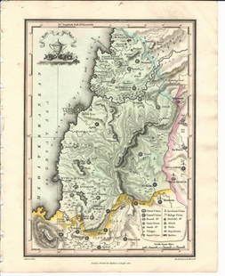
5 days LeftJasper521650 c. Stella Map of Germany's Harz Mountain Area -- Comitatus Mansfeldiae DescriptioUS$95
Jun 02Schilb Antiquarian Rare Books1871 Holy BIBLE & MAPS Holy Land Hitchcock Analysis Gruden Concordance TheologyUS$82(2 bids)
1 day LeftTrillium Antique Prints & Rare BooksDavid Roberts - View from under the Portico of the Temple of DenderaUS$200
1 day LeftTrillium Antique Prints & Rare BooksDavid Roberts - Fragments of the Great Colossi, at the MemnoniumUS$200
1 day LeftHess Fine AuctionsAntique Sword Knights Of Columbus Charles Miesse Ornate Inscribed Holy Land Blade Fancy Helmet HiltUS$40(2 bids)
6 days LeftZikorn Arts & History ObjectsSteven Brooke, Signed 1st Edition: Views of Jerusalem & the Holy LandUS$50
Swann Auction GalleriesWomen in the Holy Land. Five Titles in Seven Volumes from the 19th Century.US$425
Swann Auction GalleriesWomen in the Holy Land. Six Titles in Eight Volumes from the 19th Century.US$425
3 days LeftActivity Auctions**Original 1960 Vintage Poster HOLY LAND FLY TWA ***JETS Israel Airline Travel Tourism**US$700(1 bid)
1 day LeftActivity Auctions***Original Vintage Poster EL AL HOLY LAND Israel Airline Travel Tourism LINEN***US$900
1 day LeftActivity AuctionsOriginal Vintage Poster EL AL HOLY LAND Israel Airline Travel Tourism LINENUS$900


![1550 Munster Map of Holy Land and Cyprus -- [Holy Land and Cyprus]: Title: 1550 Munster Map of Holy Land and Cyprus -- [Holy Land and Cyprus] Cartographer: S Munster Year / Place: 1550, Basel Map Dimension (in.): 10.8 X 6.7 in. This a superb woodblock map of the Holy](https://p1.liveauctioneers.com/5584/265564/138674312_1_x.jpg?height=310&quality=70&version=1666735666)