Sold2015Map of the People Dispersion after the Flood. 1829.Print of steel engraving titled Carte dela Dispersion des Peuples apres le Deluge“.Author Fellx Delamarche.Engraved by unknown.From Atlas de la Geographie ancienne du moyen age et moderne“ by FellSee Sold Price
Sold2019Delamarche, Felix 1829 Map Dispersion of People, World"Carte de la Dispersion des Peuples apres le Deluge" Copper Engraved Map Published 1829, Paris for "Atlas de La Geographie..." by Felix Delamarche. Contemporary outline hand colour. Centre fold as pubSee Sold Price
Sold2017The USA Map 1829, Engraving by W. Darton, London, UKThe United States of America, 1829 by W. Darton Junior, Holborn Hill. England. Hand colored engraved atlas map. Relief is shown pictorially. Map framed, matted and glazed. Publisher 1829, William DartSee Sold Price
Sold2018Antique Survey Map of Earliest American Railroad PlanTitle/Content of Map: 1829 Survey Map of the Earliest American Railroad Plan -- Plan of a Survey for the Proposed Boston and Providence Rail-Way Date Printed: 1828 Boston Cartographer: J Hayward Size:See Sold Price
Sold2019People's Handy Atlas of the WorldTitle/Content of Map: People's Handy Atlas of the World Date: c1911 Cartographer: GEOGRAPHICAL PUBLISHING CO Publisher: GEOGRAPHICAL PUBLISHING CO Size: 7.9"H x 5.8"W (1910 Census edition) ContainingSee Sold Price
Sold2017Malte-Brun: Antique Map of Europe in 1829Title/Content of Map: 1829 Malte-Brun Map of Europe in 1829 -- Europe en 1829 Date Printed: 1829, Paris Cartographer: M Malte-Brun Size: 8.7 X 11.7 in. An attractive map of Europe showing its politicaSee Sold Price
Sold2019(25) RPPC LAKE DESOLATION NY LAKES, LANDSCAPES, PEOPLE,(25) RPPC LAKE DESOLATION NY LAKES, LANDSCAPES, PEOPLE, FLOOD, ETC. FROM ESTATE POSTCARD COLLECTION OF ANTHONY "TONY" BASILE, OF ALBANY, NEW YORK.See Sold Price
Sold20181829 Malte-Brun Map of Germany -- ConfederationReserve Reduced! Title/Content of Map: 1829 Malte-Brun Map of Germany -- Confederation Germanique en 1829 Date: 1829, Paris Cartographer: M Malte-Brun Size: 11.7 x 8.8 in. An attractive map of GermanSee Sold Price
Sold2017Group of Harpers Weekly Civil War Era Pages and PrintsFeaturing Maps, People, and Other MiscellaneousSee Sold Price
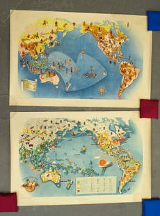
Sold2021Covarrubias Pacific Asia Pictorial Maps (2)Maps of the Pacific, Golden Gate International Exposition. NY, 1942. Miguel Covarrubias (1904-1957). 2 Maps: Peoples and Economy. Australia, Hawaii, Asia, Americas. .See Sold Price
Sold2023Carte des Etats-Unis du Mexique & Guatemala. Mexico USA Southwest LAPIE 1829 mapCAPTION PRINTED BELOW PICTURE: Carte des Etats-Unis du Mexique // Carte du Guatemala, ou Provinces-Unies de l'Amérique centrale [The United States of Mexico // Guatemala, or the United ProvincesSee Sold Price
Sold2024Carte des Antilles, du golfe du Mexique… Caribbean & West Indies. LAPIE 1829 mapCAPTION PRINTED BELOW PICTURE: Carte des Antilles, du golfe du Mexique et d'une partie des Etats voisins [The Antilles, the Gulf of Mexico and part of the neighbouring states] DATE PRINTED: The publicSee Sold Price
Sold2019Delamarche, Felix 1829 Map of World Hemispheres"Mappe-Monde ou Carte Generale du Globe Terrestre" Copper Engraved Map Published 1829, Paris for "Atlas de La Geographie..." by Felix Delamarche. Contemporary outline hand colour. Centre fold as publiSee Sold Price
Sold20201913 European Language, Religion and People's MapTitle: 1913 European Language, Religion and People's Map Author: Perthes Medium: Ink on Paper Dimensions: 14"X12" Description: Map of Europe dated 1913 engraved by Julius Perthes. It captures people'sSee Sold Price
Sold2019Delamarche, Felix 1829 Map of the Old World"Orbis Antiqui Mappa Nova" Copper Engraved Map Published 1829, Paris for "Atlas de La Geographie..." by Felix Delamarche. Contemporary outline hand colour. Centre fold as published. Paper Size: 18.5 xSee Sold Price
Sold2019Delamarche, Felix 1829 Map of North America. USA"Amerique Septentrionale" Copper Engraved Map Published 1829, Paris for "Atlas de La Geographie..." by Felix Delamarche. Contemporary outline hand colour. Centre fold as published. Paper Size: 18.5 xSee Sold Price
Sold2019Delamarche, Felix 1829 Map of Ancient Italy"Italie Antiquae Mappa Nova" Copper Engraved Map Published 1829, Paris for "Atlas de La Geographie..." by Felix Delamarche. Contemporary outline hand colour. Centre fold as published. Paper Size: 18.5See Sold Price
Sold2019Delamarche, Felix 1829 Map of Austria Empire & Poland"Confederation Germanique Royaume de Prusse Empire d'Autriche royaume de Pologne" Copper Engraved Map Published 1829, Paris for "Atlas de La Geographie..." by Felix Delamarche. Contemporary outline haSee Sold Price
Sold2019Delamarche, Felix 1829 Map of South America"Amerique Meridionale" Copper Engraved Map Published 1829, Paris for "Atlas de La Geographie..." by Felix Delamarche. Contemporary outline hand colour. Centre fold as published. Paper Size: 18.5 x 13See Sold Price
Sold2019Delamarche, Felix 1829 Map Naples Sicily Sardinia ItalyCopper Engraved Map Published 1829, Paris for "Atlas de La Geographie..." by Felix Delamarche. Contemporary outline hand colour. Centre fold as published. Paper Size: 18.5 x 13 inch (47 x 33cm) SmallSee Sold Price
Sold2019Delamarche, Felix 1829 Map of Turkey in Europe"Turquie d'Europe" Copper Engraved Map Published 1829, Paris for "Atlas de La Geographie..." by Felix Delamarche. Contemporary outline hand colour. Centre fold as published. Paper Size: 18.5 x 13 inchSee Sold Price
Sold2019Delamarche, Felix 1829 Map of Ancient Greece"Graeciae Antiquae" Copper Engraved Map Published 1829, Paris for "Atlas de La Geographie..." by Felix Delamarche. Contemporary outline hand colour. Centre fold as published. Paper Size: 18.5 x 13 incSee Sold Price
Sold2019Delamarche, Felix 1829 Map of The British Isles"Iles Britanniques" Copper Engraved Map Published 1829, Paris for "Atlas de La Geographie..." by Felix Delamarche. Contemporary outline hand colour. Centre fold as published. Paper Size: 18.5 x 13 incSee Sold Price
Sold2019Delamarche, Felix 1829 Map of Europe Continent"L'Europe Divisee en ses differens Etats" Copper Engraved Map Published 1829, Paris for "Atlas de La Geographie..." by Felix Delamarche. Contemporary outline hand colour. Centre fold as published. PapSee Sold Price
1 day LeftPotter & Potter AuctionsLINDGREN, Hjalmer “Jolly” (1895–1952). A Hysterical Map of ...US$150(1 bid)
Featured15 hrs LeftJasper52Carte de l'Europe… l'invasion des barbares. Barbarian invasions. LAPIE 1830 mapUS$50
15 hrs LeftJasper52Carte des Royaumes de Belgique & Hollande. Belgium Netherlands. LAPIE 1833 mapUS$35
15 hrs LeftJasper52Carte de la Scandinavie… Scandinavia Sweden Norway Denmark. LAPIE 1830 old mapUS$45
Jun 07Freeman's | HindmanHOMANN, Johann Baptist. Amplissimae Regionis Mississipi Seu Provinciae Ludovicianae. Nuremburg, [caUS$400
1 day LeftPotter & Potter AuctionsBOURNE, Emma (1906 – 1986). America – A Nation of One Peopl...US$125(1 bid)
1 day LeftPotter & Potter AuctionsBATE, Neel (1916 – 1989). Jimmy and Sally in Mother Goose L...US$200
1 day LeftPotter & Potter AuctionsGEESINK, Joop (1913 – 1984). Europa. 1957. Netherlands: KLM...US$100
1 day LeftPotter & Potter AuctionsSabena Belgian World Airways. 1969. Belgium: Marci/PV Pub. ...US$200
1 day LeftPotter & Potter AuctionsBODLEY, Helen (1906 – 1997). A Map of Concord / The Old Mus...US$400


![Carte des Antilles, du golfe du Mexique… Caribbean & West Indies. LAPIE 1829 map: CAPTION PRINTED BELOW PICTURE: Carte des Antilles, du golfe du Mexique et d'une partie des Etats voisins [The Antilles, the Gulf of Mexico and part of the neighbouring states] DATE PRINTED: The public](https://p1.liveauctioneers.com/5584/316569/169897396_1_x.jpg?height=310&quality=70&version=1706046386)


