Sold20231738 HISTORY OF JEWS H. Prideaux 6 VOL. antique ILLUSTRATED MAPS VELLUM JudaicaA Six-Volume Edition of Humphrey Prideaux's "History of the Jews" Storia de Giudei e de popoli vicini, dalla decadenza de i Reami d'Israele, e di Guida sino alla morte di Gesu' Cristo [History of theSee Sold Price
Sold20241744 ROMAN HISTORY w/ MAP BLINDSTAMPED VELLUM BINDING ANTIQUEEpitome Rerum Romanorum - 1744 by Carolus Andreas Dukerus (Karl Andreas Duker) Lugduni Batavorum, apud Samuelem Luchtmans, 1744 (56)-858-(122)(index)-39 pp. Size 5 1/4 by 8 1/3" (13 × 21.5 cm.) VSee Sold Price
Sold20241704 BIBLE HISTORY CHRONOLOGY & GEOGRAPHY ILLUSTRATED w/ MAPS antique VELLUMIntroductio In Lectionem Novi Testamenti In qua, quae ad rem criticam Historiam, Chronologiam et Geographiam pertinent, Breuiter et Perspicue Exponuntur Johann Georg Pritius (Georgii Pritii) (IntroducSee Sold Price
Sold2021Kent Estate Map, Chevening.- Barham (surveyor) The HomeKent Estate Map, Chevening.- Barham (surveyor) The Home Farm In Chevening Kent Belonging to The Ri.t Hon.ble Lord Amherst, manuscript watercolour estate map on vellum, fold, 475 x 500mm., 1797; and anSee Sold Price
Sold2023Railroad Map: Carson & Colorado Proposed 1889 Extension [170579]Large 22"x 42" hand drawn original map on vellum map of the "Proposed Extension of the Carson & Colorado Railroad from Keeler to Mahave. The scale is four miles to the inch. The map was compiled by L.See Sold Price
20231744 ROMAN HISTORY ARMORIAL VELLUM BINDING antique w/ MAP by LUCIUS FLORUSLucius Annaeus Florus Epitome Rerum Romanarum Ed. C.A. Duker. Leyden, S. Luchtmans, 1744 2 parts in 1 vol. (58),858[= 874],(120),39[= 47],(1)p. Engraved frontispiece, folding map Original vellum, schoSee Sold Price
Sold2015Early Printed Books [Group of 5]1: C. Julii Caesaris Commentarii de Bello Gallico et Civili…. Halle Im Magdeburgischen : Zufinden in der Rengerischen buchhandlung, 1718. Frontis, [22], 690, + 6 folding maps. Full vellum tonedSee Sold Price
Sold2024[VELLUM DEEDS, MAPS] COOK, ROWLANDSON, ETC. 100+VELLUM DEEDS, MAPS, ENGRAVINGS. A lot of approximately 100+ pieces sold together. Condition and sizes vary. Maps of China, Africa, Pacific; engraved plates from CAPTAIN COOK'S VOYAGE (late 1700s); engSee Sold Price
Sold20231632 EUROPE DESCRIPTION by MERCURII GALLOBEGICI antique VELLUM BOUND w/ MAPMERCURII GALLOBEGICI sive, rerum in Gallia et Belgio potissimum; Hispania quoqve Italia, Anglia, Germania, Ungaria, Bohemia... Frankfurt; 1632 Illustrated with one plate and the map of Western EuropeSee Sold Price
Sold20231693 HISTORY of BELGIUM ILLUSTRATED w/ MAP FOLIO antique CHRONICON vellumCHRONICON BALDUINI AVENNENSIS TOPARCHAE BELLIMONTIS SIVE HISTORIA GENEALOGICA COMITUM HANNONIAE ALIORUMQUE PRINCIPUM ANTE ANNOS QU[ADR]INGENTOS CONSCRIPTA [...]. by BAUDOUIN of AVESNES Antwerp; 1693 FSee Sold Price
Sold2019Johann Jacob Scheurmann," Atlas de la Suisse Zurich",Johann Jacob Scheurmann," Atlas de la Suisse Zurich", folding vellum on linen Map Set of 18 Folders in original box, 1822, Each- H. -9 in., W. -13 in.See Sold Price
Sold20231744 ROMAN HISTORY AMSTERDAM ARMORIAL VELLUM BINDING antique w/ MAP by L. FLORUSLucius Annaeus Florus Epitome Rerum Romanarum Ed. C.A. Duker. Leyden, S. Luchtmans, 1744 3 parts in 1 volume (58),426; (2),427-858,(66); 39,(1)p. With manuscript dedication on first free endpaper. EngSee Sold Price
Sold20241797 WORLD'S HISTORY antique ILLUSTRATED w/ MAP of ARABIA in German VELLUM BOUNDUebersetzung der Algemeinen Welthistorie die in Engeland durch eine Geselschaft von Gelehrten ausgefertiget worden (General World's History) By Siegmund J. Baumgarten Written in England by a society oSee Sold Price
Sold20211744 ROMAN HISTORY by Lucius Florus antique VELLUMLucius Annaeus Florus. L. Annaei Flori Epitome Rerum Romanarum Lugduni Batavorum, 1744 (60), 858, Index (39) pp. Size 5 1/2 by 8 1/4" bound in original vellum. With fold-out map of Roman Empire Very gSee Sold Price
Sold2021VOL. ESPECTACULO DE LA NATURALEZA W/ TERRESTRIAL MAPSVOLUME ESPECTACULO DE LA NATURALEZA W/ PULL OUT TERRESTRIAL GLOBE MAPS, MADRID/TRINIDAD, C. 1754, (VELLUM COVER AS IS)See Sold Price
Sold20231722 ROMAN HISTORY ARMORIAL VELLUM BOUND antique ILLUSTRATED w/ MAP by FLORUSLucius Annaeus Florus Epitome Rerum Romanarum Leyden, 1722 Schoolprize armorial binding Original vellum, central gilt coat of arms of UTRECHT within border with armorial cornerpieces on both covers BiSee Sold Price
Sold20231642 HISTORY of ULTRECHT NETHERLANDS antique VELLUM BOUND FOLIO in LATIN w/ MAPDE EPISCOPIS ULTRAIECTINIS, RECOGNITI ET NOTIS HISTORICIS ILLUSTRATI AB ARN. BUCHELIO BATAVO I.C. ACCEDUNT LAMB. HORTENSII MONTFORTII SECESSIONUM ULTRAIECTINARUM LIBRI, ET SIFFRIDI PETRI FRISII APPENDSee Sold Price
Sold20241868 TRAVELS in EAST INDIAN ARCHIPELAG0 by ALBERT BICKMORE illustrated ANTIQUEBICKMORE, ALBERT S. Travels in the East Indian Archipelago. London: John Murray,1868 First Edition Later half vellum. Frontispiece, 560 pp., 2 folded maps and 35 plates Light soiling to binding, a genSee Sold Price
Sold2021Manuscript Map of the Holy Land, early 18th Century[Manuscript map of the Holy Land] Pencil, ink, and watercolor on faux vellum with horizontal and vertical folding creases (8 segments) and no mounting guard; pencil grid visible in upper left and righSee Sold Price
Sold20211658 LUCANUS DE BELLO CIVILI antique VELLUM PharsaliaLUCANUS. De bello civili. Cum H. Grotii, Farnabii notis integr. & var. selectiss. Précis. C. Schrevelio. Leiden, F. Hackius, 1658. With engraved title & 1 fold out map. 614 pages plus index. SizeSee Sold Price
Sold2020British Greywell Indenture Map 1847British land indenture from 1847, ink on vellum, contract between Basingstoke Canal Navigation and the landowner, Baron Dorchester, to do work on the Greywell Canal, a road and tunnel which still exisSee Sold Price
Sold20221708 ALEXANDER THE GREAT HISTORY ARMORIAL VELLUM BINDING antique ILLUSTRATEDCurtius Rufus G. Alexander Magnus. Ed. S. Pitiscus. The Hague, P. van Thol, 1708 (68),855,(169)p. Engraved frontispiece by J. VAN DEN AVELEN after G. HOET, 16 engravings, folding maps/ plans/ views anSee Sold Price
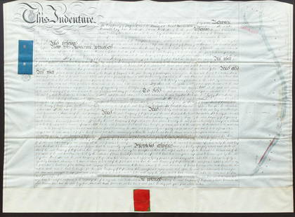
Sold20181870 Handwritten Indenture DeedAntique indenture dated March 16, 1870, handwritten on vellum. Indenture appears to be the conveyance of property in the "Borough of Kings Lynn". A small map of the property is printed in the center lSee Sold Price
1 day LeftJasper521759 HISTORY OF THE WORLD in GERMAN antique ILLUSTRATED w/ MAP of ARABIA vellumUS$200
BonhamsVENEGAS, MIGUEL. 1680-1764. Noticia de la California, y desu conquista temporal, y espiritual ha...US$7,000
3 days LeftNY Elizabeth 1760 WORLD'S HISTORY ON OLD GERMAN VELLUM, ILLUSTRATED WITH A MAP OF CENTRAL ASIAUS$100
1 day LeftJasper521686 OPERA OMNIA by John LIGHTFOOT antique VELLUM BOUND FOLIO w/ MAP of ISRAELUS$170
1 day LeftJasper521733 BIBLE OLD TESTAMENT COMMENTARY by CALMET VELLUM FOLIO antique w/ LARGE MAPUS$160
3 days LeftNY Elizabeth M. HANSIZ'S 1729 GERMANIA SACRA BLINDSTAMPED PIGSKIN ANTIQUE FOLIO WITH MAPUS$100
3 days LeftNY Elizabeth ANTIQUE ROMAN ARMORIAL VELLUM BINDING, 1744, ILLUSTRATED WITH AN ANTIQUE MAP BY FLORUSUS$100
1 day LeftJasper521696 SYRIA Asia Minor & Syrian-Arabic region HISTORY antique ILLUSTRATED vellumUS$340
22 hrs LeftFreeman's | Hindman[Early Printing] [Incunable] (Macrobius, Ambrosius Aurelius Theodosius: In Somnium Scipionis expositUS$300
3 days LeftForum AuctionsDeseine (François) Rome Moderne, vol.2-6 only (of 6), engraved plates, contemporary calf over£75
3 days LeftNY Elizabeth 1709 SEPTUAGINT GREEK BIBLE ILLUSTRATED WITH MAPS, VINTAGE VELLUM BOUND VERSIONUS$100(1 bid)
3 days LeftNY Elizabeth D. BLONDEL GENEALOGIAE FRANCICAE VELLUM ANCIENT FOLIO MAPS 1654 HISTORY OF FRANCEUS$100
22 hrs LeftFreeman's | Hindman[Maps & Atlases] Oliva, Joan: Portolan Chart of the MediterraneanUS$10,000(1 bid)
1 day LeftJasper521710 HISTORY by LIVY 10 volumes Historiarum quod extat antique VELLUM BINDINGUS$650
3 days LeftA.H. Wilkens Auctions & AppraisalsENGLISH FAIRY TALES ILLUSTRATED BY ARTHUR RACKHAMCA$1,000
3 days LeftA.H. Wilkens Auctions & AppraisalsBARRIE & RACKHAM. PETER PAN IN KENSINGTON GARDENSCA$2,000


![Railroad Map: Carson & Colorado Proposed 1889 Extension [170579]: Large 22"x 42" hand drawn original map on vellum map of the "Proposed Extension of the Carson & Colorado Railroad from Keeler to Mahave. The scale is four miles to the inch. The map was compiled by L.](https://p1.liveauctioneers.com/2699/299063/159201766_1_x.jpg?height=310&quality=70&version=1692045182)
![1744 ROMAN HISTORY ARMORIAL VELLUM BINDING antique w/ MAP by LUCIUS FLORUS: Lucius Annaeus Florus Epitome Rerum Romanarum Ed. C.A. Duker. Leyden, S. Luchtmans, 1744 2 parts in 1 vol. (58),858[= 874],(120),39[= 47],(1)p. Engraved frontispiece, folding map Original vellum, scho](https://p1.liveauctioneers.com/5584/292108/154819414_1_x.jpg?height=310&quality=70&version=1686690530)
![Early Printed Books [Group of 5]: 1: C. Julii Caesaris Commentarii de Bello Gallico et Civili…. Halle Im Magdeburgischen : Zufinden in der Rengerischen buchhandlung, 1718. Frontis, [22], 690, + 6 folding maps. Full vellum toned](https://p1.liveauctioneers.com/3532/74226/38363209_1_x.jpg?height=310&quality=70&version=1435683690)
![[VELLUM DEEDS, MAPS] COOK, ROWLANDSON, ETC. 100+: VELLUM DEEDS, MAPS, ENGRAVINGS. A lot of approximately 100+ pieces sold together. Condition and sizes vary. Maps of China, Africa, Pacific; engraved plates from CAPTAIN COOK'S VOYAGE (late 1700s); eng](https://p1.liveauctioneers.com/8124/322212/173234973_1_x.jpg?height=310&quality=70&version=1709937662)

![1693 HISTORY of BELGIUM ILLUSTRATED w/ MAP FOLIO antique CHRONICON vellum: CHRONICON BALDUINI AVENNENSIS TOPARCHAE BELLIMONTIS SIVE HISTORIA GENEALOGICA COMITUM HANNONIAE ALIORUMQUE PRINCIPUM ANTE ANNOS QU[ADR]INGENTOS CONSCRIPTA [...]. by BAUDOUIN of AVESNES Antwerp; 1693 F](https://p1.liveauctioneers.com/5584/273386/143235584_1_x.jpg?height=310&quality=70&version=1672180773)


![Manuscript Map of the Holy Land, early 18th Century: [Manuscript map of the Holy Land] Pencil, ink, and watercolor on faux vellum with horizontal and vertical folding creases (8 segments) and no mounting guard; pencil grid visible in upper left and righ](https://p1.liveauctioneers.com/1968/225974/116712048_1_x.jpg?height=310&quality=70&version=1636655147)


![[Early Printing] [Incunable] (Macrobius, Ambrosius Aurelius Theodosius: In Somnium Scipionis exposit (1 of 3)](https://p1.liveauctioneers.com/65/332523/179335062_1_x.jpg?height=282&quality=70&version=1717709446)


![[Maps & Atlases] Oliva, Joan: Portolan Chart of the Mediterranean (1 of 2)](https://p1.liveauctioneers.com/65/332523/179335172_1_x.jpg?height=282&quality=70&version=1717709445)


