Sold2017Mitchell: Map of North Western America/Alaska, 1870Map: North Western America showing the territory ceded by Russia to the United States Cartographer: S. A. Mitchell Place & Date: Philadelphia / 1870 Size: 14 1/2" x 11 5/8" Condition: full color; lighSee Sold Price
Sold20181871 Mitchell Antique Map of AlaskaTitle/Content of Map: 1871 Mitchell Map of Alaska -- North Western America Showing the Territory Ceded by Russia to the United States Date Printed: 1871, Philadelphia Cartographer: S Mitchell Size: 11See Sold Price
Sold20181870 Mitchell Map of North America -- Map of NorthTitle/Content of Map: 1870 Mitchell Map of North America -- Map of North America Showing Its Political Divisions and Recent Discoveries in the Polar regions Date Printed: 1870, Philadelphia CartographSee Sold Price
Sold20191876 Mitchell Map of Mexico, Caribbean and HawaiiTitle/Content of Map: 1876 Mitchell Map of Mexico, Caribbean and Hawaii [verso] Cuba [verso] Alaska -- Map of Mexico, Central America and the West Indies [verso] Cuba [verso] North Western America ShoSee Sold Price
Sold2019Map of Ore., Wash., Idaho & Montana, Mitchell 1860.Nice map of the northwestern states from Mitchell's 1864 New General Atlas published by S. Augustus Mitchell. One of the earliest maps to depict the new Territory of Montana (1864.) Maps from this perSee Sold Price
Sold2020Mitchell Map of Western U.S.*** START PRICE IS THE RESERVE *** [America] MITCHELL, Samuel Augustus (1792-1868). A New Map of Texas, Oregon and California with the Regions Adjoining. Engraving with original hand color, with origiSee Sold Price
Sold20181858 Mitchell Map of North America -- No. 3 Map ofTitle/Content of Map: 1858 Mitchell Map of North America -- No. 3 Map of North America Date: 1858, Philadelphia Cartographer: S Mitchell Size: 10.8 x 8.3 in. A very nice map of North and Central AmeriSee Sold Price
Sold2022Mitchell map of North America, 1860Decorative map of North America, hand-colored by country. Shows recent discoveries in Russian America, including McClure's northwest passage aboard the Investigator. Nebraska Territory is shown goingSee Sold Price
Sold2018Mitchell Map of North America, 1850Excellent hand colored, engraved map of the North American continent originally created by S. Augustus Mitchell in 1850. Thomas, Cowperthwait & Co. bought out Mitchell that year. They published this mSee Sold Price
Sold20231869 Mitchell Map of North America [verso] Eastern Canada -- III Map of North America [verso] IVTitle: 1869 Mitchell Map of North America [verso] Eastern Canada -- III Map of North America [verso] IV Dominion of Canada Cartographer: S Mithchell Year / Place: 1869, Philadelphia Map Dimension (in.See Sold Price
Sold20191858 Mitchell Map of North America -- No 4 Map of NorthTitle/Content of Map: 1858 Mitchell Map of North America -- No 4 Map of North America Date: 1858, PhiladelphiaCartographer: S Mitchell Size: 10.4 X 8.2 in. A nice pre-Civil War map of North America, fSee Sold Price
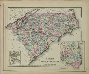
Sold20221877 Mitchell Map of North and South Carolina -- North and South CarolinaTitle: 1877 Mitchell Map of North and South Carolina -- North and South Carolina Cartographer: S Mitchell Date/Place: 1877 Philadelphia Dimensions: 10.5 x 13.5 in. Description: This is an excellent anSee Sold Price
Sold20201869 Mitchell Map of Western US [verso] Mexico andTitle: 1869 Mitchell Map of Western US [verso] Mexico and Central America -- XIX California, Oregon, Idaho, Utah, Nevada, Arizona and Washington [verso] XX Mexico and Central America Cartographer: S MSee Sold Price
Sold20211887 Mitchell Map of North and South Carolina -- NorthTitle: 1887 Mitchell Map of North and South Carolina -- North and South Carolina Cartographer: S Mitchell Year / Place: 1887, Philadelphia Map Dimension (in.): 11.3 X 14 in. A very nice map of the CarSee Sold Price
Sold20181867 Mitchell Map of North and South Carolina -- CountyTitle/Content of Map: 1867 Mitchell Map of North and South Carolina -- County Map of North and South Carolina Date: 1867, Philadelphia Cartographer: S Mitchell Size: 11.5 x 13.8 in. This is a handsomeSee Sold Price
Sold20211884 Mitchell Map of North and South Carolina -- NorthTitle: 1884 Mitchell Map of North and South Carolina -- North and South Carolina Cartographer: S Mitchell Year / Place: 1884, Philadelphia Map Dimension (in.): 11.3 X 14 in. This is a very nice map ofSee Sold Price
Sold20241869 Mitchell Map of Western [verso] Eastern Hemispheres -- The Western Hemisphere Map No. 1…Title: 1869 Mitchell Map of Western [verso] Eastern Hemispheres -- The Western Hemisphere Map No. 1… [verso] The Eastern Hemisphere Map No. 2… Cartographer: S Mithchell Year / Place: 1869,See Sold Price
Sold2017Mitchell: Map of North America, 1848North America, S. Augustus Mitchell, 1848. 13 x 15.75 inches. Great transitional map showing political boundaries within that short time period after the Canadian/U.S. boundary settlement and before tSee Sold Price
Sold20231891 Mitchell Map of Western US -- Map of Oregon, Kansas, California and the Territories.Title: 1891 Mitchell Map of Western US -- Map of Oregon, Kansas, California and the Territories. Cartographer: S Mitchell Year / Place: 1891, Philadelphia Map Dimension (in.): 8.2 X 10.6 in. This is aSee Sold Price
Sold20181876 Mitchell Map of North and South Carolina -- NorthReserve Reduced! Title/Content of Map: 1876 Mitchell Map of North and South Carolina -- North and South Carolina Date: 1876 Philadelphia Cartographer: S Mitchell Size: 10.5 x 13.5 in. Excellent and hiSee Sold Price
Sold20241837 Map of North Western Italy with Sardinia By A. PerrotTitle: 1837 Map of North Western Italy with Sardinia By A. Perrot Date/Period: 1837 Materials: Copperplate engraved Size: 7 x 10 3/4” This is a map of North western Italy with Sardinia from 1837See Sold Price
Sold2018Mitchell: Antique Map of North & Central America, 1852Title/Content of Map: 1852 Mitchell Map of North and Central America -- Map of North America Date Printed: 1852, Philadelphia Cartographer: S Mitchell Size: 10.6 x 8 in. A very nice map of North AmeriSee Sold Price
Sold2017Mitchell: Antique Map of North America, 1894Map: 1894 Mitchell Map of North America -- Map of North America Showing its Political Divisions, and Recent Discoveries in the Polar Regions Cartographer: S Mitchell / AL Smith (Pub) Year / Place: 189See Sold Price
Sold2017Mitchell: Antique Map of North America, 1867Map: 1867 Mitchell Map of North America -- Map of North America Showing its Political Divisions, and Recent Discoveries in the Polar Regions Cartographer: S Mitchell Year / Place: 1867 Philadelphia DiSee Sold Price
Featured1 day LeftJasper52India North Western Frontier Kashmir Pamir region Afghanistan. STANFORD 1896 mapUS$280
Featured1 day LeftJasper52Asie. Tartarie #42 South Kazakhstan. North Kyrgyzstan. VANDERMAELEN 1827 mapUS$60
Featured7 hrs LeftJasper521878 Mitchell Map of Virginia and West Virginia [verso] New Jersey, Maryland and Delaware -- CountyUS$45
2 days LeftHannam's Auctioneers LtdLORD KRISHNA AND THE BATHING GOPIS Jaipur School, Rajasthan, North-Western India, ca. 1880 - 1920 Op£400


![1876 Mitchell Map of Mexico, Caribbean and Hawaii: Title/Content of Map: 1876 Mitchell Map of Mexico, Caribbean and Hawaii [verso] Cuba [verso] Alaska -- Map of Mexico, Central America and the West Indies [verso] Cuba [verso] North Western America Sho](https://p1.liveauctioneers.com/5584/155577/78518607_1_x.jpg?height=310&quality=70&version=1574821323)

![Mitchell Map of Western U.S.: *** START PRICE IS THE RESERVE *** [America] MITCHELL, Samuel Augustus (1792-1868). A New Map of Texas, Oregon and California with the Regions Adjoining. Engraving with original hand color, with origi](https://p1.liveauctioneers.com/1968/163248/82424595_1_x.jpg?height=310&quality=70&version=1583340284)


![1869 Mitchell Map of North America [verso] Eastern Canada -- III Map of North America [verso] IV: Title: 1869 Mitchell Map of North America [verso] Eastern Canada -- III Map of North America [verso] IV Dominion of Canada Cartographer: S Mithchell Year / Place: 1869, Philadelphia Map Dimension (in.](https://p1.liveauctioneers.com/5584/293457/155766102_1_x.jpg?height=310&quality=70&version=1687903812)


![1869 Mitchell Map of Western US [verso] Mexico and: Title: 1869 Mitchell Map of Western US [verso] Mexico and Central America -- XIX California, Oregon, Idaho, Utah, Nevada, Arizona and Washington [verso] XX Mexico and Central America Cartographer: S M](https://p1.liveauctioneers.com/5584/188299/94765046_1_x.jpg?height=310&quality=70&version=1608072723)


![1869 Mitchell Map of Western [verso] Eastern Hemispheres -- The Western Hemisphere Map No. 1…: Title: 1869 Mitchell Map of Western [verso] Eastern Hemispheres -- The Western Hemisphere Map No. 1… [verso] The Eastern Hemisphere Map No. 2… Cartographer: S Mithchell Year / Place: 1869,](https://p1.liveauctioneers.com/5584/319185/171438530_1_x.jpg?height=310&quality=70&version=1707858212)


![1878 Mitchell Map of Virginia and West Virginia [verso] New Jersey, Maryland and Delaware -- County (1 of 2)](https://p1.liveauctioneers.com/5584/329422/177662152_1_x.jpg?height=282&quality=70&version=1715717898)


