Sold2018MITCHELL, Samuel Augustus (1790-1868).* MITCHELL, Samuel Augustus (1790-1868). A New Universal Atlas Containing Maps of the Various Empires, Kingdoms, States, and Republics of the World, with a Special Map of Each of the United States, PlSee Sold Price
Sold2022Mitchell's Map of the states of Louisiana, Mississippi, & Alabama 1834MITCHELL, Samuel Augustus (1790-1868). Map of the states of Louisiana, Mississippi, & Alabama. Engraved map with original hand color. Philadelphia: S. Augustus Mitchell, 1834. 17 1/2" x 12 1/2" sheet.See Sold Price
Sold20171852 S.A. MITCHELL MAP OF THE STATE OF TEXASFramed "Map of the State of Texas, Engraved to Illustrate Mitchell's School and Family Geography", 1852 by S.A. Mitchell (Samuel Augustus Mitchell, Philadelphia, 1790-1868), engraved by J.H. Young, haSee Sold Price
Sold20171846 S.A. MITCHELL MAP OF THE STATE OF TEXASFramed "Map of the State of Texas, Engraved to Illustrate Mitchell's School and Family Geography", 1846 by S. Augustus Mitchell (Samuel Augustus Mitchell, Philadelphia, 1790-1868), with notations in aSee Sold Price
Sold2019Samuel Augustus Mitchell (1790-1868), "County Map ofSamuel Augustus Mitchell (1790-1868), "County Map of the States of Georgia and Alabama," 1860, H.- 12 1/4 in., W.- 15 3/8 in.See Sold Price
Sold2019Samuel Augustus Mitchell (1790-1868), "Plan of NewSamuel Augustus Mitchell (1790-1868), "Plan of New York," 1866, Atlas, H.- 15 3/4 in., W.- 12 3/8 in.See Sold Price
Sold2023An 1860 Map, Counties of New York, New Hampshire, Etc...Hand colored lithograph, by Samuel Augustus Mitchell (1790-1868). :County Map of the States of New York, New Hampshire, Vermont, Massachusetts, Rhode Island and Connecticut". Dimensions:15 1/2" x 23 1See Sold Price
Sold2019Two Maps by Samuel Augustus Mitchell (1790-1868), "MapTwo Maps by Samuel Augustus Mitchell (1790-1868), "Map of North America," No. 4, 1852, hand colored, H. -11 1/2 in., W. - 9 1/8 in. (2 Pcs.)See Sold Price
Sold2019Samuel Augustus Mitchell (1790-1868), "Map of the StateSamuel Augustus Mitchell (1790-1868), "Map of the State of Texas," 1852, No. 13, hand colored, H. -9 in., W. - 15 3/8 in.See Sold Price
Sold2019Three Copies of Samuel Augustus Mitchell (1790-1868),Three Copies of Samuel Augustus Mitchell (1790-1868), "Plan of New Orleans," 1862, hand colored, H. -11 1/4 in., W. - 15 1/8 in.See Sold Price
Sold2019Two Copies of Samuel Augustus Mitchell (1790-1868),Two Copies of Samuel Augustus Mitchell (1790-1868), "Northern Portion of New York City and Brooklyn County," 1880, hand colored, H.-15 1/4 in., W.- 24 1/4 in. (2 Pcs.)See Sold Price
Sold2019Samuel Augustus Mitchell (1790-1868), "County Map ofSamuel Augustus Mitchell (1790-1868), "County Map of Scotland and Ireland," 1852, hand colored, H.-11 5/8 in., W.- 9 1/4 in.See Sold Price
Sold2019Samuel Augustus Mitchell (1790-1868), "Plan ofSamuel Augustus Mitchell (1790-1868), "Plan of Chicago/Vicinity and Springfield en verso," 1877, H. - 15 in., W. -12 in.See Sold Price
Sold2019Two Maps by Samuel Augustus Mitchell (1790-1868),Two Maps by Samuel Augustus Mitchell (1790-1868), consisting of "Western Hemisphere", 1874, hand colored, H. -15 1/4 in., W. - 11 3/4 in.; together with "Eastern Hemisphere", 1884, hand colored, H. -1See Sold Price
Sold2019Samuel Augustus Mitchell (1790-1868), "Map of NorthSamuel Augustus Mitchell (1790-1868), "Map of North America," 1852, H. - 11 1/2 in., W. - 9 in.See Sold Price
Sold2019Samuel Augustus Mitchell (1790-1868), "Oregon,Samuel Augustus Mitchell (1790-1868), "Oregon, Washington, Idaho and Part of Montana," 1866, hand colored, H.-12 3/8 in., W.- 15 1/2 in.See Sold Price
Sold2019Samuel Augustus Mitchell (1790-1868), "Plan of NewSamuel Augustus Mitchell (1790-1868), "Plan of New Orleans," 1884, hand colored, H.-11 1/2 in., W.- 15 1/8 in.See Sold Price
Sold2019Samuel Augustus Mitchell (1790-1868), "County Map ofSamuel Augustus Mitchell (1790-1868), "County Map of the State of Illinois," 1861, hand colored, H.-15 1/4 in., W.- 12 3/8in.See Sold Price
Sold2019Two Copies of Samuel Augustus Mitchell (1790-1868),Two Copies of Samuel Augustus Mitchell (1790-1868), "Map of the United States," 1877, H. - 11 1/2 in., W. -15 in. (2 Pcs.)See Sold Price
Sold2019Samuel Augustus Mitchell (1790-1868), "County Map ofSamuel Augustus Mitchell (1790-1868), "County Map of Florida," 1867, Atlas, with an inset of Mobile, H.- 12 in., W.- 12 3/8 in.See Sold Price
Sold2019Samuel Augustus Mitchell (1790-1868), "Map of theSamuel Augustus Mitchell (1790-1868), "Map of the United States," 1852, hand colored, H.-11 1/4 in., W.- 18 in.See Sold Price
Sold2019Two Maps by Samuel Augustus Mitchell (1790-1868),Two Maps by Samuel Augustus Mitchell (1790-1868), "United States and Territories together with Canada," 1860," hand colored, H.-15 1/4 in., W.- 23 1/8 in. (2 Pcs.)See Sold Price
Sold2019Samuel Augustus Mitchell (1790-1868), " Plan of NewSamuel Augustus Mitchell (1790-1868), " Plan of New Orleans," 1870, hand colored, H.-12 1/2 in., W.-15 1/4 in.See Sold Price
Sold2019Three Maps by Samuel Augustus Mitchell (1790-1868),Three Maps by Samuel Augustus Mitchell (1790-1868), "County Map of England and Wales," 1860, hand colored, H.-15 3/8 in., W.- 12 1/8 in. (3 Pcs.)See Sold Price
Featured52 mins LeftJasper52Mitchell’s Map of Asia showing travel routes London, India, China & Japan, 1860US$45
2 days LeftHeritage Auctions74137: A Samuel Merriman Coin Silver Child's Porringer,US$650(2 bids)
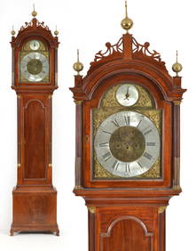
Jun 02Tremont AuctionsSamuel Mulliken mahogany tall case clock with composite brass dial, circa 1790. The Chippendale caseUS$1,200
Jun 07Freeman's | HindmanCLEMENS, Samuel Langhorne ("Mark Twain"). Cabinet card photograph of Mark Twain. 1905. INSCRIBED BYUS$3,000
JG AutographsRobert Monsey Rolfe, 1st Baron Cranworth - British Lord High Chancellor - Autographed DocumentUS$20
2 days LeftFreeman's | HindmanAlfred Thompson Bricher (American, 1837-1908) Autumn IdyllI, 1868US$10,000(1 bid)