Sold2023AMERICA H. Moll Geographer 1732 MapHerman Moll 1732 Map of the Americas, North and South America with California depicted as an island. Hand Colored engraving 8 1/2 x 11 in Matt.See Sold Price
Sold2017FRAMED WORLD MAP BY HERMAN MOLL, 1719'A New & Correct Map of the Whole World, by Herman Moll, Geographer, 1719.' Hand tinted and framed. Frame size: 73 x 124 cm (28 3/4 x 48 3/4 in.)See Sold Price
Sold2023HERMAN MOLL (ENGLISH, C. 1654-1732) MAP OF NORTH AND SOUTH CAROLINAHERMAN MOLL (ENGLISH, C. 1654-1732) MAP OF NORTH AND SOUTH CAROLINA, hand-colored engraving on laid paper, titled "CAROLINA / By / H. Moll Geographer" in a rectangular cartouche along lSee Sold Price
Sold2023Three Herman Moll maps of the West IndiesThree 18th century Herman Moll maps of the West Indieslot consists of three maps : 1. The Island of Jamaica, Divided into its Principle Parishes, with the roads etc. H. Moll Geographer; from Moll's AtSee Sold Price
Sold2019Map of Persia by H. Moll & Plan of ConstantinopleMap of Persia by H. Moll & Plan of Constantinople. This lot includes a map of Persia by H. Moll Geographer and an engraving of the plan of Constantinople by Bosphoror Thracio. Larger measures 13 incheSee Sold Price
Sold2023Asia by Herman Moll. Great Wall of China. Mogol empire. Tartaria 1709 old mapTitle: Asia by Herman Moll. Great Wall of China. Mogol empire. Tartaria 1709 old map Description: Asia' by Herman Moll (1709). Antique copperplate map, 29.5 x 19.5cm, 11.5 x 7.75 inches The mythical lSee Sold Price
Sold20151729 MAP OF POLAND BY HERMAN MOLL1729 MAP OF POLAND BY HERMAN MOLL 1729 map of "Poland subdivided into its several Palatinates & c. Agreeable to Modern History" by Herman Moll, Geographer. In cardboard matting with a caption paper inSee Sold Price
Sold20151729 POLAND MAP BY HERMAN MOLL1729 POLAND MAP BY HERMAN MOLL 1729 map of Poland "Subdivided into its several Palatinates & c. Agreeable to Modern History" by Herman Moll, Geographer. #24/102. In a cardboard matte with a caption paSee Sold Price
Sold2021Collection of Antique Maps of North AmericaA framed collection of nine small maps including "The English Empire in America, Newfound-Land, Canada, Hudsons Bay &c. in Plano" by Herman Moll circa 1709 and "North America from the Best AuthoritiesSee Sold Price
Sold2023c. 1715 Netherlands by H. Moll [Map]Black and white map with minor hand colorization by Herman Moll, a geographer and cartographer. Moll was born in Bremen and went to London about 1675, possibly as a refugee from the turmoil of the ScaSee Sold Price
Sold2018HARRY BERTOIA/KNOLL ASSOCIATES; MARCEL BREUERDiamond chair and ottoman, together with Wassily chair, NY, latter half 20th c. Chromed steel, stitched saddle leather Unmarked Wassily: 28 1/2" x 31" x 27", Diamond chair: 28" x 44" x 31", ottoman: 1See Sold Price
Sold2017Japanese Tin Litho Battery Operated Gang of Five SonicWorks well. Some slight scratching and crazing. Slight bit of restoration inside the battery box. Condition:(Excellent).Dimensions:15 - 1/2" T.See Sold Price
Sold2023SteinmesserÄgypten, Frühdynastisch, 3500–3000 v. Chr. Obsidian. Sehr fein gearbeitetes Messer aus Obsidian. L 17,2 cm, B 5,6 cm.- Bestossen.See Sold Price
Sold2023HUGE XXL Signed Pollock Abstract Art Painting on CanvasHUGE XXL Signed Jackson Pollock Abstract Art Painting on Canvas. Stamped on Reverse. Approx Canvas Size:98 x 58 1/2 inches.Painting is done in the modern abstract expressionist style for which PollockSee Sold Price
Sold2024Vladimir Kagan style Modernist Cloud Sofa Couch. Dusty pink upholstery. Unmarked.Vladimir Kagan style Modernist Cloud Sofa Couch. Dusty pink upholstery. Unmarked. Dimensions: Height: 29.5 inches, Width: 88 inches, Depth: 38.5 inches. - Seat Height: 15.5 inches --- - - We offer curSee Sold Price
Sold2022Four Moroccan polychrome 'Fez' pottery dishes, 19/20th C.Full title: Four Moroccan polychrome 'Fez' pottery dishes, 19/20th C. Description: Dia 30 cm (the largest) About this sale: Paul De Grande is one of the major dealers of antique furniture, fine sculptSee Sold Price
Sold2016ALVAR AALTODining table, six chairs, and two stools, Finland, 1950s; Birch plywood, laminate, vinyl upholstery; One stool and three chairs with Finmar label; Table: 30" x 72" x 38 3/4"See Sold Price
Sold2020NORTHERN ITALIEN/VENETIAN SCHOOL Master, active in theNORTHERN ITALIEN/VENETIAN SCHOOL Master, active in the middle of the 17th century. SAINT JEROME Oil on canvas. 68 cm x 54 cm (F. 84 cm x 70 cm). Part. min. old restored. Frame. Provenance: Rhenish PriSee Sold Price
Sold2024John Bowles (British 1709 - 1779)John Bowles (British 1709 - 1779) "A New and Exact Map of America Laid Down from the Latest Observations and Discoveries", circa 1750 Two sheet map engraving of the "Representation of the Customs andSee Sold Price
Sold2022BEAVER MAP, HERMAN MOLL (DUTCH/BRITISH, 1654-1732)A New and Exact Map of the Dominions of the King of Great Britain on ye Continent of North America containing Newfoundland, New Scotland, New England, New York, New Jersey, Pensilvania, Maryland, VirgSee Sold Price
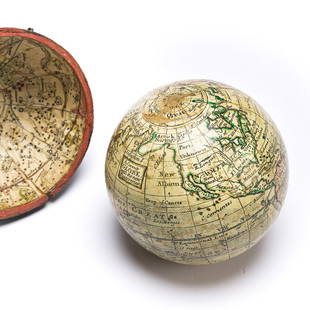
Sold2023(GLOBES.) Style of Herman Moll. A Correct Globe with the New Discoveries.(GLOBES.) Style of Herman Moll. A Correct Globe with the New Discoveries. 2¾-inch miniature terrestrial pocket globe comprised of 12 hand-colored engraved gores and 2 polar calottes on a plasterSee Sold Price
Sold2024Map of the North Parts of America Claimed by France by Herman Moll (London, 1720)Map of the North Parts of America Claimed by France by Herman Moll (London, 1720) "A New Map of the North Parts of America claimed by France under ye Names of Louisiana, Mississippi, Canada, and New FSee Sold Price
Sold2020Herman Moll Emanuel Bowen "A Complete System of GHerman Moll (ca. 1654-1732) and Emanuel Bowen (1694-1767), "A Complete System of Geography," London, 1747. Volumes I and II. The title page reads: "A Complete System of Geography. Being a DescriptionSee Sold Price
Sold2017Moll - Correct Map of the Whole World, 1719Herman Moll (1654?-1732), cartographer and publisher A New & Correct Map of the Whole World Shewing y.e Situation of its Principal Parts. Viz the Oceans, Kingdoms, Rivers, Capes, Ports, Mountains, WooSee Sold Price
Jun 25Freeman's | Hindman[Fishing] (Walton, Izaak): The Compleat Angler or the Contemplative man's Recreation. Being a DiscouUS$15,000
Jun 25Freeman's | Hindman[Fishing] [Gosden, Thomas] (Walton, Izaak): The Compleat Angler or the Contemplative man's RecreatioUS$250(1 bid)
Jun 25Freeman's | Hindman[Fishing] (Walton, Izaak): The Compleat Angler or the Contemplative man's Recreation. Being a DiscouUS$1,500
Jun 25Freeman's | Hindman[Fishing] (Walton, Izaak): The Compleat Angler or the Contemplative man's Recreation. Being a DiscouUS$300(1 bid)
Jun 25Freeman's | Hindman[Fishing] (Walton, Izaak): The Compleat Angler or the Contemplative man's Recreation. Being a DiscouUS$200(1 bid)
Jun 25Freeman's | Hindman[Fishing] (Nobbes, Robert): The Compleat Troller, or, the Art of Trolling…US$250(1 bid)
Jun 25Freeman's | Hindman[Fishing] Walton, Izaak, and Charles Cotton: Group of 8 editions of "The Compleat Angler"US$250(1 bid)
Jun 22GOLDFIELD AUCTIONPaul DUPRE-LAFON (1900-1971) Luminous globe, brass base, published by J. Forest, geographer in€3,000
Jul 21The Heritage Gallery at Sayville Antiques, IncLouis de Moll FAIA Watercolor Architectural Study City StreetUS$50
Jun 27NY Elizabeth 1709 SEPTUAGINT GREEK BIBLE ILLUSTRATED WITH MAPS, VINTAGE VELLUM BOUND VERSIONUS$100
BonhamsSTIRRUP (THOMAS) Horometria: Or the Compleat Diallist: Wherein the Whole Mystery of the Art of D...£10(1 bid)
Crawford Family Auctions LLCTrio of prints with Ships, 2x framed John Moll pieces, and one John WhealtonUS$5
4 days LeftJasper521709 GREEK BIBLE ILLUSTRATED w/ MAPS antique VELLUM BOUND Septuagint editionUS$440


![c. 1715 Netherlands by H. Moll [Map]: Black and white map with minor hand colorization by Herman Moll, a geographer and cartographer. Moll was born in Bremen and went to London about 1675, possibly as a refugee from the turmoil of the Sca](https://p1.liveauctioneers.com/7226/294713/156486873_1_x.jpg?height=310&quality=70&version=1688308988)


![[Fishing] (Walton, Izaak): The Compleat Angler or the Contemplative man's Recreation. Being a Discou (1 of 2)](https://p1.liveauctioneers.com/65/332523/179335085_1_x.jpg?height=282&quality=70&version=1717709446)
![[Fishing] [Gosden, Thomas] (Walton, Izaak): The Compleat Angler or the Contemplative man's Recreatio (1 of 3)](https://p1.liveauctioneers.com/65/332523/179335079_1_x.jpg?height=282&quality=70&version=1717622830)
![[Fishing] (Walton, Izaak): The Compleat Angler or the Contemplative man's Recreation. Being a Discou (1 of 3)](https://p1.liveauctioneers.com/65/332523/179335086_1_x.jpg?height=282&quality=70&version=1717709446)
![[Fishing] (Walton, Izaak): The Compleat Angler or the Contemplative man's Recreation. Being a Discou (1 of 2)](https://p1.liveauctioneers.com/65/332523/179335087_1_x.jpg?height=282&quality=70&version=1717709446)
![[Fishing] (Walton, Izaak): The Compleat Angler or the Contemplative man's Recreation. Being a Discou (1 of 2)](https://p1.liveauctioneers.com/65/332523/179335088_1_x.jpg?height=282&quality=70&version=1717709446)
![[Fishing] (Nobbes, Robert): The Compleat Troller, or, the Art of Trolling… (1 of 2)](https://p1.liveauctioneers.com/65/332523/179335083_1_x.jpg?height=282&quality=70&version=1717709446)
![[Fishing] Walton, Izaak, and Charles Cotton: Group of 8 editions of "The Compleat Angler" (1 of 1)](https://p1.liveauctioneers.com/65/332523/179335093_1_x.jpg?height=282&quality=70&version=1717622830)


