Sold2023MAP, Germany, MunsterSouthern Germany. Sebastian Munster, Das Algow, from Cosmographey oder Beschreibung Aller Laender, 1578 (published). Hand Color. This charming woodblock map of southwestern Bavaria oriented with northSee Sold Price
Sold2024MAP, Balkans, MunsterIstria Peninsula, Croatia. Sebastian Munster, [Title on Verso] Hysterreich, from Cosmographei oder Beschreibung aller Länder, 1556 (published). Hand Color. Woodblock map of Istria, in present-day CroSee Sold Price
Sold2023Calmet, Augustin 1732 Large Map. Old World according to Noah's Sons"A Geographical Map of the Old World according to the division of it among Noah's Sons" Folio Copper Plate Published 1732, London for "An Historical, Critical, Geographical, Chronological and EtymologSee Sold Price
Sold2023Munster map of World 1550Heading: (Maps) Author: Münster, Sebastian Title: Das Erst General/inhaltend die beschzeibung und den Circkeldes gantzen Erdtrichs und Moze Place Published: [Basle] Publisher: Date Published: </See Sold Price
Sold2022Cellarius & Patrick 1816 Map. Hemisphere, Old WorldCopper Engraved Map Published 1816, London for "Geographia Antiqua" by Samuel Patrick. Maps based on those by Andreas Cellarius. Folds as issued. Paper Size: 10 x 8 inch (26 x 20cm) Good ConditionSee Sold Price
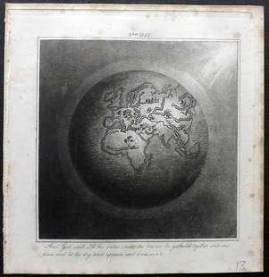
Sold2019Rhind, William 1844 Rare Map of the Old World. EarthAquatint Map Published 1844, London "The Creation: Illustrated By Six Engravings On Steel" by William Graeme Rhind. Rare. Paper Size: 6.5 x 6 inch (16.5 x 16cm) Very minor margin toning, slightly affeSee Sold Price
Sold2022Framed Needlepoint Old World Map Antique needlepoint of the world featuring the oceans and nauticalAntique needlepoint of the world featuring the oceans and nautical references.Framed 20.5" x 20"STERLING ASSOCIATES STRIVES TO PROVIDE ACCURATE, OBJECTIVE, & FAIR INFORMATION ON ALL LOTS. WE WILL BE HSee Sold Price
Sold20221814 map of the Old World, WilkinsonExcellent map of the Old World titled “Terra Veteribus Nota” (Land of the Old) from An Atlas Of Ten Select Maps Of Ancient Geography Both Sacred And Profane; With A Chronological Table OfSee Sold Price
Sold2019Embossed Leather Decanter w Old World Map DesignEmbossed Leather Decanter w Old World Map Design. Measures 10 inches in height.See Sold Price
Sold2023A Grouping of 17th & 18th Century Old World Maps Lot of 6Lot Includes: The English Channel, A Map of France, North American Rivers and Lakes Between Superior and Slave Lake (2), A New map of Russia in Europe, & Nouvelle Carte Du Royaume de Bengale EngraSee Sold Price
Sold20166 PC VINTAGE MID CENTURY BARWARE, OLD WORLD MAP DESIGN,6 PC VINTAGE MID CENTURY BARWARE, OLD WORLD MAP DESIGN, INCLUDES PITCHER APPROX 8"H, 4 GLASSES APPROX 3.25"H, & WOODEN TRAY APPROX 12" X 8.5"See Sold Price
Sold2019Delamarche, Felix 1829 Map of the Old World"Orbis Antiqui Mappa Nova" Copper Engraved Map Published 1829, Paris for "Atlas de La Geographie..." by Felix Delamarche. Contemporary outline hand colour. Centre fold as published. Paper Size: 18.5 xSee Sold Price
Sold2024OLD WORLD MAP LEATHER TRAVEL CASE 15"-OLD WORLD MAP LEATHER TRAVEL CASE -SIZE: 15" X 12" -PREOWNED VINTAGE CONDITION -SEE ALL PHOTOS-JR BTQ 02/01 Bidders may pick up their items from the auction-house or have their items shipped.AppointmSee Sold Price
Sold2017Framed Print Basset Mirror Co. Old World MapFramed Print. Basset Mirror Co. print depicting an old world map, 28 3/4"h. 34 1/2"w.See Sold Price
Sold2020Old World Map Modern Briefcase/Tote Approx 16x10"Old World Map Modern Briefcase/Tote Approx 16x10" Approx 16x10"See Sold Price
Sold2022Vintage Old World Map Drinking Glasses (2)Vintage Old World Map Drinking Glasses (2)See Sold Price
Sold2023Buffon & Vaugondy 1830 Map of the Old World"Carte de L'Ancien Continent" Lithograph Published 1828-33, Brussels for "Oeuvres completes de Buffon" by the Comte de Buffon and Louis-Jean-Marie Daubenton. Folds as issued. Paper Size: 12 x 10 inchSee Sold Price
Sold2015Two Hand-Colored Old World MapsTwo Hand-Colored Old World Maps of England/Wales and the Americas, consisting of "Accuratissima Angliae Regni et Walliae Principatus...", engraved by Cornelis Danckerts, ca. 1690-1700, plate 20-1/2" xSee Sold Price
Sold2023(2) Reprints of Old World MapsTwo reprints of old world maps We happily provide seamless shipping services on everything we sell. Please email us at shipping@vogtauction.com or call 210-971-5750 for more information.See Sold Price
Sold2022Ancient world’s climates based on Strabo, 1701-1706 by Christoph CellariusTitle: Ancient world’s climates based on Strabo, 1701-1706 by Christoph Cellarius Date/Period: 1701-1706 Materials: Copperplate engraved Size: 13x9" Beautiful map shows the old world climates acSee Sold Price
Sold2023Antique Carte Pour L' Intelligence Du Livre Institute L' Esprit De S Loix Old World Framed MapAntique French framed old world map with gold tone frame. Professionally framed. Measures 15 1/2" x 24" total with 9" x 18" matte.See Sold Price
Sold20212 Sets Vintage Georges Briard & Cera Art Glasses2 Sets Vintage Georges Briard & Cera Art Glasses / Barware. Georges Briard Set of 6 glasses with blue, turquoise & gilt droplet design. Cera Set of 8 glasses of Old World Map with gilt accents. LargesSee Sold Price
3 days LeftJasper52New Guinea-Solomon Islands 1942/3. Pacific Campaign. World War 2 1961 old mapUS$10
3 days LeftJasper52Marianas April-July 1944. World War 2. Saipan Guam. Pacific Ocean 1961 old mapUS$8
2 days LeftJasper521598 Munster Map of Northern Adriatic Coastal Areas -- Sclavonia oder Windisch Marck Bossen CrabatenUS$140


![MAP, Balkans, Munster: Istria Peninsula, Croatia. Sebastian Munster, [Title on Verso] Hysterreich, from Cosmographei oder Beschreibung aller Länder, 1556 (published). Hand Color. Woodblock map of Istria, in present-day Cro](https://p1.liveauctioneers.com/6576/320593/172252548_1_x.jpg?height=310&quality=70&version=1708729193)

![Munster map of World 1550: Heading: (Maps) Author: Münster, Sebastian Title: Das Erst General/inhaltend die beschzeibung und den Circkeldes gantzen Erdtrichs und Moze Place Published: [Basle] Publisher: Date Published: </](https://p1.liveauctioneers.com/642/299378/159362943_1_x.jpg?height=310&quality=70&version=1692570425)