Sold2017Naval Chart of the Pacific and Western AtlanticU.S. CONGRESS, HYDROGRAPHIC OFFICE. U.S. NAVY, 1894, Folio – 22.25 H x 25.50 W Inches, Congressional reprint of a Navy chart that shows Trust terriories claimed by Britain, France and Germany. NiceSee Sold Price
Sold20231740 New Map or Chart Western Atlantic OceanFolding map being "A New Map or Chart of the Western or Atlantic Ocean with part of Europe Africa and America" Shewing the Course of the Galleons, Flota and C to the West Indies" piublished in 1740 anSee Sold Price
Sold20231740 New Map or Chart Western Atlantic OceanFolding map being "A New Map or Chart of the Western or Atlantic Ocean with part of Europe Africa and America" Shewing the Course of the Galleons, Flota and C to the West Indies" published in 1740 andSee Sold Price
Sold20181740 Large Folding Chart Western AtlanticA New Map of Chart of the Western or Atlantic Ocean with part of Europe Africa and America: Shewing the Course of the Galleons, Flota, and C to and from the West Indies, London, printed for E. Cave atSee Sold Price
Sold20231872 Western Pacific Chart #2 James L. McCray & Son, London50" x 40 3/4". Vertical tear is appr. 24". Some staining and edge wear. See photos for condition and details. Local pick-up available on February 4th or 3rd party shipping available. Please see termsSee Sold Price
Sold2019Emanuel Bowen (1693-1767, "A New and Accurate Chart ofEmanuel Bowen (1693-1767, "A New and Accurate Chart of the Western Atlantic Ocean," 1778, H.- 9 in., W.- 14 1/2 in.See Sold Price
Sold20151844 J W Norie “Chart of the Western or Atlantic1844 J W Norie “Chart of the Western or Atlantic Ocean†(rough as found condition, tears & creases, losses) with cloth wrapper inscribed by owner H H McCarthy Boston, 3'2†x 4'1â€See Sold Price
Sold2022Thomas Bowen,1778, Map, Western Atlantic Ocean"Thomas Bowen, London 1778, A New & Accurate Chart of the Western or Atlantic Ocean Drawn from Surveys and most approved Maps & Charts" by Thomas Bowen. Hand colored, modern framing. Dimensions:SightSee Sold Price
Sold2019Emanuel Bowen (1694-1767), "A New and Accurate ChartEmanuel Bowen (1694-1767), "A New and Accurate Chart of the Western or Atlantic Ocean," 1788, matted and mounted, hand colored, H. - 10 in., W. - 12 1/2 in.See Sold Price
Sold2018Western or Atlantic Ocean Color Map 1740A New Map or Chart of the Western or Atlantic Ocean, with part of Europe, Africa & America. 1740. Printed for E. Cave, London. 15" x 12". We ship all items in this auction in-house with the most fairSee Sold Price
Sold2023Atlantic & Pacific Railroad Western Division Annual Pass [154183]"California, Arizona, New Mexico." Pass No. 630, issued for 1887 to DJ Flanders. Signed by H.C. Nutt as president. Printed on cardstock by American Bank Note Co., Boston. Ornate logo with floral bordeSee Sold Price
Sold2023Two California "Pacific" Railroad Annual Passes [167938]Lot of 2 different. 1) Atlantic & Pacific Railroad, Western Division. Pass no. 1258 issued to Geo. Cook of the AT&SF. Signed by general manager Robinson. Black print on green cardstock. The Atlantic aSee Sold Price
Sold201524 Vintage stock certificates24 Vintage stock certificates including; Nation Tea Co. New York Central RR, United stores, Watham Watch, Great Atlantic & Pacific Tea Co. Western Union, Chicago, Rock Island & Pacific RR, PRR, GeneraSee Sold Price
Sold2020THOMSON, JOHN. Atlantic or Western Ocean.THOMSON, JOHN. Atlantic or Western Ocean. Double-page engraved chart of the northern Atlantic Ocean showing a pronounced outline of the Gulf Stream. 20½x25½ inches sheet size, ample margins;See Sold Price
Sold2019Western Trip Passes 1873 + 4 AnnualsA group of 4 1873 western trip passes and 4 annual passes from the 20th century. The old westerns include: Denver & Pacific Railway, Atlantic & Pacific, Union Pacific, Kansas City St Joe & Council BluSee Sold Price
Sold2023Twenty-nine Mixed Cabooses-HO ScaleThis is a lot of 29 mixed cabooses in HO scale. Roads represented include CP Rail, Santa Fe, Southern Pacific, Norfolk and Western, Rock Island, Conrail, Soo Line, Atlantic Coast Line, Conrail, UnionSee Sold Price
Sold2024Group of 4 HO Scale Steam Locomotives and TendersIncludes central pacific, Denver and rio grande, AT and SF, western and AtlanticSee Sold Price
Sold2016Litho. of a Boy in Naval Uniform, "On Deck".Lithograph on Paper of a Boy in a Naval Uniform, Titled "On Deck". Hand written note on back "copyrighted 1894 by Atlantic A Pacific Tea Co., New York. Framed 31" x 17" overall. Condition: Some tearsSee Sold Price
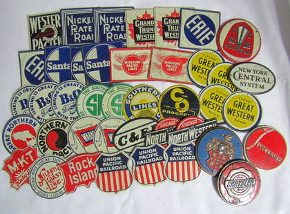
Sold2022Cereal Premiums, PatchesRail road cereal premiums including North Western, Great Northern, Atlantic Coast, MKT, Union Pacific Railroad, and Illinois Central, Harlem Globetrotters, Detroit Tigers, Bobcat, Capricorn and otherSee Sold Price
Sold2023(42) METAL RAILROAD MINI VINTAGE SIGNSNEW YORK CENTRAL SYSTEM, KATY LINES, ATLANTIC COAST LINE, ROCK ISLAND, UNION PACIFIC RAILROAD, NORTH WESTERN & MORESee Sold Price
Sold2019US Stock Certificates #106017United Stores 1931-39 x7, Berkey & Gay Furnace 1947 x4, Maracaibo Oil Exploration 1938-53 x 9, Great Atlantic & Pacific Tea Co 1963-73 x7, Western Union 1970 x4, American Sugar 1965 x 9 State: City: DSee Sold Price
Sold2023Atlantic & Pacific Telegraph Company Frank Pass [154179]Very rare; we haven't offered one of these before. No. 209, issued for 1877 to George Bachelder for all points on Franklin Lines. Preprinted signature of president Echert. Black print on grey/green caSee Sold Price
Sold2022Atlantic & Pacific G&S - Very Rare Nye County Territorial Stock [144394]# 453 for 100 shares to NH Lyon Jr. signed by J Sewell and Preston Hodges. Dateline New York 1866. 25c Power of Att'y revenue stamp. Not cancelled. Two mining vignettes and one Native American vignettSee Sold Price
Sold2021Telegraph Report of the Atlantic and Pacific TelegraphFour page report which shows they had a line from New York to Chicago and were currently working around Pennsylvania. Lists receipts and expenses. Also lists officers in New York Albany, Detroit, ClevSee Sold Price
1 day LeftChurchill GalleriesCHART: South Pacific Ocean / SOCIETY ISLANDS - WESTERN GROUP/ HUAHINE TO MAUPITI With theUS$10
6 days LeftRail & Road AuctionsSix Cunard Line and White Star Steamship Paper Items - Travel Guides, Brochures, 1929 PassengerUS$40
May 18MusicGoldmine.comGotye ft. Kimbra "Somebody That I Used To Know" RIAA 6X Multi-Platinum Digital Single Award - NewUS$250
May 15University ArchivesEarly Arctic Exploration: "Journal of a Voyage for the Discovery of a North-West Passage" by WilliamUS$500
May 16Zikorn Arts & History ObjectsWest Indies, Western Cuba 1879 British Admiralty Nautical MapUS$100
420 Lots AwayThe Written Word AutographsRARE Naval Book Signed By Nimitz, Forrestal, Radford and ReevesUS$250
4 days LeftJasper52Central America Caribbean Gulf of Mexico chart Ports lighthouses LARGE 1918 mapUS$45


![Atlantic & Pacific Railroad Western Division Annual Pass [154183]: "California, Arizona, New Mexico." Pass No. 630, issued for 1887 to DJ Flanders. Signed by H.C. Nutt as president. Printed on cardstock by American Bank Note Co., Boston. Ornate logo with floral borde](https://p1.liveauctioneers.com/2699/282572/149010310_1_x.jpg?height=310&quality=70&version=1679417398)
![Two California "Pacific" Railroad Annual Passes [167938]: Lot of 2 different. 1) Atlantic & Pacific Railroad, Western Division. Pass no. 1258 issued to Geo. Cook of the AT&SF. Signed by general manager Robinson. Black print on green cardstock. The Atlantic a](https://p1.liveauctioneers.com/2699/291513/154445577_1_x.jpg?height=310&quality=70&version=1685892308)


![Atlantic & Pacific Telegraph Company Frank Pass [154179]: Very rare; we haven't offered one of these before. No. 209, issued for 1877 to George Bachelder for all points on Franklin Lines. Preprinted signature of president Echert. Black print on grey/green ca](https://p1.liveauctioneers.com/2699/282572/149010388_1_x.jpg?height=310&quality=70&version=1679417398)
![Atlantic & Pacific G&S - Very Rare Nye County Territorial Stock [144394]: # 453 for 100 shares to NH Lyon Jr. signed by J Sewell and Preston Hodges. Dateline New York 1866. 25c Power of Att'y revenue stamp. Not cancelled. Two mining vignettes and one Native American vignett](https://p1.liveauctioneers.com/2699/258191/134290908_1_x.jpg?height=310&quality=70&version=1660351799)


