Sold2018North Sea countries. Rare Map of Scandanavia. BritishNorth Sea countries. Rare Map of Scandanavia. British isles to Greenland 1740-70's J.N. Bellin & J.F. La Harpe 14 1/2" x 19 1/3" Copperplate engraved. Published in Paris. From the 'Aberge de L'HistoirSee Sold Price
Sold20185th C. North European / Russian Bronze Bracelets (3)**Originally Listed At $500** Northern Europe, Scandinavia / British Isles / Russia, Migration period, ca. 5th to 9th century CE. A trio of cast bronze bracelets, including one of an incredible deep tSee Sold Price
Sold2021Bartholomew, John 1889 Lot of 5 World, Europe MapsIncl Natural Productions, Chart of the World of showing Heights and Depths, Sketch Chart of the North Atlantic, Railway Map of Central Europe, and Railway Map of British Isles. Lithograph Maps PublishSee Sold Price
Sold2017[World War One - Maps] WWI Military Maps of North West[World War One - Maps] WWI Military Maps of North West Europe, Belgium and France, Lot of 3 Three Military maps issued by the British Army, Geographical Services. Typical topographic maps with towns,See Sold Price
Sold2018Normandy/Ile de France. World War 2 pre-D-Day militaryTITLE/CONTENT OF MAP: 'North west Europe. Rouen-Paris - Army/Air. Sheet 7' The map was published by the (British) War Office in 1943, with magnetic north dated to June 1943 - a year before the D-Day lSee Sold Price
Sold2021Goldsmith, J. 1852 Lot of 15 Maps and Prints6 Maps of Africa, Canaan/Palestine, Asia, Central Europe, British Isles, and Europe. Together with 9 Prints showing Astronomy, Brunei/New Zealand/Sydney, Cairo/Egypt/Algiers, New York/North American ISee Sold Price
Sold2019Philip, George C1895 Lot of 6 British County MapsIncl Worcestershire, Yorkshire North West, Somersetshire, Cheshire, Sussex, and Westmorland. Lithograph Maps Published C1895 by George Philip & Son, London for "Phillips' Atlas of the British Isles" CSee Sold Price
Sold2022Aiken, John 1795 Lot of 10 British Maps. Manchester & North WestCopper Plate Published 1795, London for "A Description of the Country from Thirty to Forty Miles Round Manchester" by John Aiken. Paper Size: 11.5 x 9 inch (29 x 23cm) Some toning present, a couple wiSee Sold Price
Sold2019NORTH ATLANTIC/ARCTIC OCEANS. Greenland Iceland NorwayTITLE OF THE MAP: 'Decowerte de la Groenlande' The map extends from the British Isles to Scandinavia. Iceland. Spitzerbergen and Greenland. Ships The top image on the right hand side shows the entireSee Sold Price
Sold2020Bartholomew, John 1922 Lot of 12 European MapsOne Map of Asia continent and the others of European Countries. Incl British Isles, Belgium/Holland, Spain/Portugal, North Italy/Austria, Greece, South Italy, Central European States, and Germany SoutSee Sold Price
Sold2023Reclus, Elisee C1880 Lot of 6 Antique Maps of EuropeIncl Belgium/Netherlands, Scandinavia, British Isles, Volcanoes of Central France, Russia, and Central Europe. Lithograph Map Published 1876-94, London for "The Universal Geography" by Elisee Reclus.See Sold Price
Sold2023Nat. Encyclo. 1890's Mixed Lot of 32 Antique MapsIncl Sweden/Norway, Eastern USA, British Isles Geological, North America X 2, South America, Russia in Europe, Scotland, Britannia Antiqua, Suez Canal, China Proper, England and Wale, World HemisphereSee Sold Price
Sold2023SOUTH AMERICA. North-west; map of Galapagos Isles 1907 old antique chartTitle: SOUTH AMERICA. North-west; map of Galapagos Isles 1907 old antique chart Description: South America: North-West; Inset map of Galapagos Isles' by Harmsworth (1907). Colour antique map, 50.0 x 3See Sold Price
Sold2018Russia in Europe Part III (North-West: St. PetersbiurgTitle/Content of Map: Russia in Europe Part III (North-West: St. Petersbiurg to Vilna) Date: 1852 Cartographer: WALKER, J. & C./PIADICHEV/LUTKE Size: 12.25x15.3 "Published under the superintendence ofSee Sold Price
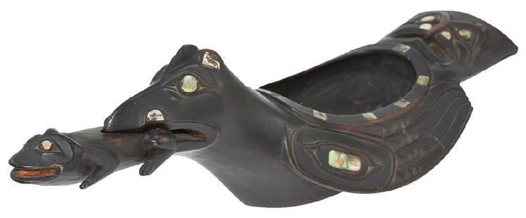
Sold201819 1/2" Haida-Tlingit Grease Bowl. Older example19 1/2" Haida-Tlingit Grease Bowl. British Columbia. Exquisite Northwest Coast, Native American, artifact. Carved Wood Bird Effigy Bowl (16 1/2") with Carved Frog (4 5/8") that insets in mouth. MotherSee Sold Price
Sold2023Laurie & Whittle Map of the British Colonies of North AmericaLAURIE, Robert (1755-1836), and WHITTLE, James (1757-1818). A New and Correct Map of the British Colonies in North America comprehending Eastern Canada...with the adjacent states of New England. EngraSee Sold Price
Sold2022BRITISH ISLES LILY (GEORGE) Britanniae insulae quae nunc Angliae et Scotiae regna continet cum H...BRITISH ISLES LILY (GEORGE) Britanniae insulae quae nunc Angliae et Scotiae regna continet cum Hibernia adiacente nova descriptio, double-page engraved map, land masses hand-coloured, title cartoucheSee Sold Price
Sold2023EDWARD LEAR (BRITISH 1812-1888), SIGEUMEDWARD LEAR (BRITISH 1812-1888)SIGEUMPencil and watercolourSigned and inscribed (lower left)16 x 52cm (6¼ x 20¼ in.)Sigeion or Sigeum (Latin) was an important site in the Troas (North-West ASee Sold Price
Sold2022British Isles.- Ortelius (Abraham) Britannicarum Insularum Vetus Descriptio, two-sheet map ofBritish Isles.- Ortelius (Abraham) Britannicarum Insularum Vetus Descriptio, two-sheet map of ancient Britain, probably engraved by Jan Wierix, with four ornate strap-work cartouches, a naval battle iSee Sold Price
Sold2021GARY RICE, NORTHWEST COAST CARVED TOTEM POLE, 1989Gary Rice (Coast Salish/British Columbia, born 1935). Carved Salish Coast totem pole in polychromed wood. Signed and dated. Approx. h. 83.25", w. 58.25", d. 8.25"See Sold Price
Sold2020HerizSecond half 19th century, 186 x 139 cm, North West Persia, Azerbaijan In addition to the large Heriz carpets exported to Western countries as of circa 1870, smaller formats were produced in Heriz andSee Sold Price
Sold2020Antique N.W Persian runner , 3 ft 8 in x 12 ft 4 inPROPERTY OF NEVADA ESTATE. Antique North West Persian runner , Circa 1920's.This auction includes antique rugs, vintage rugs, oriental rugs and tapestry collection from all major weaving countries. ThSee Sold Price
Sold2022Britain.- Speed (John) England Wales and Scotland... from a farr Larger Voulume done by John Speed,British Isles.- Speed (John) England Wales and Scotland... from a farr Larger Voulume done by John Speed, engraved title, table of distances, and 63 uncoloured engraved maps by Pieter Van den Keere inSee Sold Price
Sold2017After Rembrandt, Etching - View of AmsterdamAfter Rembrandt, framed etching of a landscape with buildings and a windmill. Possibly British Museum sanctioned print of "View of Amsterdam from the Northwest" (Kadjik). [Art: 3 1/2" x 5"; Frame: 12"See Sold Price
4 days LeftJasper52St Christophers, Nevis & St Lucia. St Kitts. West Indies. THOMSON 1830 old mapUS$120
2 days LeftFreeman's | Hindman[Maps & Atlases] A New Map of North America, with the West India Islands...US$300
6 days LeftTrillium Antique Prints & Rare BooksCaptain Cook - Hawaii: A View of Karakakooa, in Owyhee. 68US$75
6 days LeftTrillium Antique Prints & Rare BooksCaptain Cook - Tonga: The Reception of Captain Cook, in Hapaee. 14US$75
4 days LeftJasper52WEST INDIES Caribbean Windward Leeward Islands Barbados Pirates? MALLET 1683 mapUS$240
Featured4 days LeftJasper52General Map of the West Indies'. West sheet only. Bryan EDWARDS. Caribbean 1794US$700
4 days LeftJasper52HAWAII HISPANIOLA. Hawaiian Isles; Haiti San Domingo Dominican Republic 1898 mapUS$20
Jun 30Antique FactoryEllen Neel (Kwakwaka'wakw,1916-1966) Northwest Coast Native American First Nation TotemUS$140(2 bids)
Jul 07A-1 AuctionBarry Stein Oregon Artist Bronze Sculpture "The Last Samurai" Japanese Warrior 4/90 CastingUS$400(6 bids)
6 days LeftThomaston Place Auction Galleries(SET OF 8) CIRCA 1830 BRITISH CANED MAHOGANY DINING CHAIRSUS$800(1 bid)
Featured4 days LeftJasper52West Indies. Haiti/Dominican Republic borders differ. BARTHOLOMEW 1886 old mapUS$10
4 days LeftJasper52Ozama and Brujuelas Basins. Dominican Republic. Hispaniola 1885 old mapUS$10(1 bid)


![[World War One - Maps] WWI Military Maps of North West: [World War One - Maps] WWI Military Maps of North West Europe, Belgium and France, Lot of 3 Three Military maps issued by the British Army, Geographical Services. Typical topographic maps with towns,](https://p1.liveauctioneers.com/46/113409/58240767_1_x.jpg?height=310&quality=70&version=1512492316)


![[Maps & Atlases] A New Map of North America, with the West India Islands... (1 of 2)](https://p1.liveauctioneers.com/65/332523/179335173_1_x.jpg?height=282&quality=70&version=1717709447)


