Sold2023Pair of Laurie & Whittle PrintsPair of 18th century hand-colored engravings depicting British landmarks and landscapes, one depicting "A View of the Royal Palace at Hampton Court", one depicting "A West View of Richmond", 10 3/4" xSee Sold Price
Sold2021Pair of Laurie Korogoden Signed Prints 22"x18" andPair of Laurie Korogoden Signed Prints 22"x18" and Large Vintage Framed PortraitSee Sold Price
Sold2020English Caricature and Satire PrintsA Morning Visit, Laurie & Whittle, London, 1803. Together with 2 other prints, each with many caricature faces. Sights 10 1/2" x 9", 9 1/2" x 12", 11 1/4" x 8 3/4".See Sold Price
Sold2024Laurie & Whittle - Map of the Island and Kingdom of SicilyThis exceptional map is from the very handsome atlas entitled A New and Elegant Imperial Sheet Atlas; Comprehending general and particular maps of every part of the world... The work was published bySee Sold Price
Sold2023Antique View Prints Group (7)View of St. John of Lateran, at Rome, after Piranesi. Published by Laurie & Whittle, London, 1794. With additional vue d'optique published in London or Paris. Short tears, marginal chips on some notedSee Sold Price
Sold2021ENGLISH REVERSE RACEHORSE PRINT ON GLASS.Published by Laurie & Whittle, London, 1795. Hand colored mezzotint of "Skyscraper" with jockey. Bird's eye maple veneer frame is separating. 19"h. 25"w.See Sold Price
Sold202218th c. Fredrick Duke of York Hand Colored PrintPublished May 12, 1794 by Laurie & Whittle. London. Overall with frame 19-1/4" high x 15-1/4" wide. Crease to right side of mat board. Some losses to wood frame. LR IMPORTANT: Before bidding, please rSee Sold Price
Sold2017A pair of early C19th colour engravings, 'View of theA pair of early C19th colour engravings, 'View of the Isle of Tendos in the archipelago', Turkish coastal scenes, published July 20th 1818 by Whittle & Laurie of Flat Street, together with 'View of thSee Sold Price
Sold2020Laurie & Whittle Map of AmericaLAURIE & WHITTLE (Late 18th Century)The United States of America...Engraved map with original hand color in full.London: Laurie & Whittle, 1794.20 1/4" x 22 1/2" sheet.The first British map to show thSee Sold Price
Sold2023Laurie & Whittle Map of the British Colonies of North AmericaLAURIE, Robert (1755-1836), and WHITTLE, James (1757-1818). A New and Correct Map of the British Colonies in North America comprehending Eastern Canada...with the adjacent states of New England. EngraSee Sold Price
Sold2023Laurie & Whittle Map of the Southern British Colonies of AmericaLAURIE, Robert (1755-1836), and WHITTLE, James (1757-1818). A New and General Map of the Southern Dominions belonging to the United States of America... Engraved map with original hand color in outlinSee Sold Price
Sold20241794 Laurie & Whittle after Thomas Jefferys Map Of The United States Of AmericaWITH THE BRITISH POSSESSIONS OF CANADA, NOVA SCOTIA, NEW BRUNSWICK, AND NEWFOUNDLAND divided with the French, also The Spanish Territories Of Louisiana and Florida according to the Premliminary ArticlSee Sold Price
Sold2022(UNITED STATES.) Laurie & Whittle; after Thomas Jefferys. The United States of America(UNITED STATES.) Laurie & Whittle; after Thomas Jefferys. The United States of America with the British Possessions of Canada, Nova Scotia, New Brunswick and Newfoundland Divided with the French, alsoSee Sold Price
Sold2018Large Framed 1794 Map of America Laurie & Whittle1794, London New Map of America & The West India Islands. With detailed side maps of California, and Baffin & Hudson Bay. Published by Laurie and Whittle. Map measures approximately 43.5" L x 49.5" H,See Sold Price
Sold2024A New Map of the Whole Continent of North America by Laurie & Whittle (London, 1794)A New Map of the Whole Continent of North America by Laurie & Whittle (London, 1794) "A New Map of the Whole Continent of North America, Divided into North and South and West Indies. Wherein are ExactSee Sold Price
Sold2022Laurie & Whittle (Publishers), 1798, 1803 and 1804, London: The Doctor Snatching at the Guinea afterLaurie & Whittle (Publishers), 1798, 1803 and 1804, London: The Doctor Snatching at the Guinea after his Patient is Dead; A High German Doctor; and A Grave Physician and Lively Cobbler.Three hand-coloSee Sold Price
Sold20201794 Laurie & Whittle Map of the Caribbean, Mexico andTitle/Content of Map: 1794 Laurie & Whittle Map of the Caribbean, Mexico and Central America -- A New and Complete Map of the West Indies Comprehending All the Coasts and Islands Known by That Name bySee Sold Price
Sold2018LAURIE & WHITTLE BRITISH 18TH CENTURY MAP OF NORTHLAURIE & WHITTLE BRITISH 18TH CENTURY MAP OF NORTH AMERICA, hand-colored, title in cartouche to upper right corner "A NEW AND CORRECT MAP / OF THE / BRITISH COLONIES IN NORTH AMERICA / Comprehending /See Sold Price
Sold2022America.- Canada.- Laurie & Whittle (publishers) A NewAmerica.- Canada.- Laurie & Whittle (publishers) A New and Correct Map of the British Colonies in North America comprehending Eastern Canada...with the adjacent states of New England, showing from NewSee Sold Price
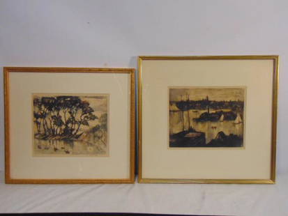
Sold2022Pair prints, William Meyerowitz, signed in pencil,Pair prints, William Meyerowitz, signed in pencil, landscape with house, pond, 8.5" by 10.25" & Harbor scene with town view, 8.5" by 10.25"See Sold Price
Sold2019Laurie & Whittle (London), The European Part of theLaurie & Whittle (London), The European Part of the Russian Empire and the Asiatic Part of the Russian Empire, 1794, H. - 21 3/8 in., W. - 532 in.See Sold Price
Sold2022Pair prints, Elyse Ashe Lord, etchings in color, portrait Asian girl, 39/75 9.75" by 8.75" & 2 AsianPair prints, Elyse Ashe Lord, etchings in color, portrait Asian girl, 39/75 9.75" by 8.75" & 2 Asian figures tending to tree, shrub, 21/75, 10" by 10"See Sold Price
Sold2019MAP - Venezuela. Laurie & WhittleVenezuela. Laurie & Whittle, Plan of the Road and Town of La Guayra on the Coast of Caraccas, by an Officer in Admiral Knowles's Squadron [on sheet with] Plan of Puerto Cavello, on the Coast of the CaSee Sold Price
Sold2016Laurie & Whittle: Spain & Portugal Map 1794Map: Spain & Portugal Publishing: Laurie & Whittle: London Date: 1794 Size: 23 x 16 inches A New Map Of The Kingdoms Of Spain And Portugal with Their Principal Divisions. Spain's provinces are readilySee Sold Price
3 days LeftPotter & Potter Auctions[RAILROADIANA]. Pair of prints. Circa 1940s-50s. Including:...US$70
May 29Adam's AuctioneersSir John Lavery RHA RA (1856-1941) Arthur Griffith and Michael Collins A pair, lithographic prints,€3,000
Jun 07TimeLine Auctions Ltd.Rembrandt Etchings from Jan Luyken Book of Trades 'Het Menselyk Bedryf'£5
5 days LeftAlice Callahan Auction HousePAIR (2) D NICKOLS PRINTS "MEDITATION GARDENDS 1 &2, 2 PIECE SET (POSSIBLE WATERCOLOR)US$54
May 291st Source ConsignmentElla Fitzegerald & Bob Marley Photography Print, a Pair by Brian O'ConneUS$60
3 days LeftLeland LittleJ. Gwyn Delin (French, 18th Century), Pair of Fencing Prints (Two Works)US$50
May 291st Source ConsignmentAlexander Chen Stereolithograph Signed and Numbered Framed Print, a PairUS$250


![MAP - Venezuela. Laurie & Whittle: Venezuela. Laurie & Whittle, Plan of the Road and Town of La Guayra on the Coast of Caraccas, by an Officer in Admiral Knowles's Squadron [on sheet with] Plan of Puerto Cavello, on the Coast of the Ca](https://p1.liveauctioneers.com/6576/136723/69438010_1_x.jpg?height=310&quality=70&version=1550846033)

![[HAND-COLORED AQUATINT]. [NELSON, Lord Horatio (1758-1805),... (1 of 1)](https://p1.liveauctioneers.com/928/328184/176813391_1_x.jpg?height=282&quality=70&version=1714496988)
![[CUPS AND BALLS]. Bartholomew Fair. Sung by Mr. Matthews, W... (1 of 1)](https://p1.liveauctioneers.com/928/329228/177514508_1_x.jpg?height=282&quality=70&version=1715272280)
![[RAILROADIANA]. Pair of prints. Circa 1940s-50s. Including:... (1 of 3)](https://p1.liveauctioneers.com/928/325952/175495378_1_x.jpg?height=282&quality=70&version=1712935174)


