Sold2021Palaeolithi Man In Eastern & Central North AmericaPalaeolithic Man In Eastern and Central North America Scarce Author: Putnam et al. Dated: 1888 Pages 28 Edition: 1st Size: 8vo<See Sold Price
Sold2022AN AMERICAN CIVIL WAR ERA MAP, "United States of North America (Eastern & Central)," LONDON,AN AMERICAN CIVIL WAR ERA MAP, "United States of North America (Eastern & Central)," LONDON, 1861-1873, THEODORE ETTLING (b. 1823), hand colored lithograph on paper, by T. Ettling, published by CasselSee Sold Price
Sold2020CIVIL WAR USA showing Union Confederate & BorderTITLE/CONTENT OF MAP: 'United States of North America (Eastern & central)' The map depicts the United States as divided in the early part of the Civil War between the Union states, the Confederate staSee Sold Price
Sold20211860 Ettling Map of United States -- United States ofTitle: 1860 Ettling Map of United States -- United States of North America (Eastern & Central) Cartographer: T Ettling Year / Place: 1860 c., London Map Dimension (in.): 33.5 X 35.5 in. joined This isSee Sold Price
Sold2017Ettling: Map of United States of North America, 1860United States of North America (Eastern & Central) T. J. Ettling, c1860 17 x 25. This great Civil War era map covers the country from the Rocky Mountains to the Atlantic seaboard. The map is engravedSee Sold Price
2018Ettling: Antique Map of USA SOUTH EAST, 1863TITLE/CONTENT OF MAP: 'United States of North America (Eastern & central)' USA SOUTH EAST. Florida Georgia Carolina coast Bahamas DATE PRINTED: 1863 IMAGE SIZE: Approx 44.5 x 32.0cm, 17.5 x 12.5 incheSee Sold Price
Sold2024Large Prehistoric Anasazi Tonto Polychrome Pottery JarNorth America, Southwest, Central eastern Arizona, Anasazi / Ancestral Puebloan, Greater Mogollon, Greater Salado, Upper Gila (Highland Salado), Tonto Polychrome, ca. 1350 to 1450 CE. A gorgeous TontoSee Sold Price
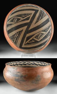
Sold2021Large Salado Tonto Polychrome Olla w/ TL TestNorth America, Southwest, Central eastern Arizona, Anasazi / Ancestral Puebloan, Greater Mogollon, Greater Salado, ca. 800 to 900 CE. A lovely hand built and sizable polychrome Tonto style olla with aSee Sold Price
Sold2024Huge Prehistoric Anasazi Gila Polychrome BowlNorth America, Southwest, Central eastern Arizona, Anasazi / Ancestral Puebloan, Greater Mogollon, Greater Salado, Upper Gila (Highland Salado), ca. 1250 to 1350 CE. A splendid pottery bowl of sizableSee Sold Price
Sold2024Prehistoric Anasazi Gila Polychrome Pottery JarNorth America, Southwest, Central eastern Arizona, Ancestral Puebloan (Anasazi), Greater Mogollon, Greater Salado, Upper Gila (Highland Salado), ca. 1250 to 1350 CE. A hand-built pottery of gently carSee Sold Price
Sold2021Anasazi / Ancestral Puebloan Gila Black-On-White Bowl**First Time At Auction** North America, Southwest, Central eastern Arizona, Anasazi / Ancestral Puebloan, Greater Mogollon, Greater Salado, Upper Gila (Highland Salado), ca. 1250 to 1350 CE. A beautiSee Sold Price
Sold2021Native American Gila Pottery BowlNorth America, Southwest, Central eastern Arizona, Anasazi / Ancestral Puebloan, Greater Mogollon, Greater Salado, Upper Gila (Highland Salado), ca. 1250 to 1350 CE. A beautiful hand-built pottery bowSee Sold Price
Sold2023Prehistoric Anasazi Gila Polychrome BowlNorth America, Southwest, Central eastern Arizona, Anasazi / Ancestral Puebloan, Greater Mogollon, Greater Salado, Upper Gila (Highland Salado), ca. 1250 to 1350 CE. A beautiful hand-built pottery bowSee Sold Price
Sold2023Matthaus Seutter Map of North AmericaColored engraving map of eastern North America by Matthaus Seutter (1678-1757). Framed; framing partially obscures borders. Map covers Eastern and Central United States and Canada, Northern Mexico, anSee Sold Price
Sold20191846 Kemble Map of Central and Eastern US DuringReserve Reduced! Map Title/Content: 1846 Kemble Map of Central and Eastern US During French, English and Spanish Colonial Period -- Map of the French, English & Spanish Possessions in North America inSee Sold Price
Sold2023Bartholomew, John 1922 Mixed Lot of 5 Large Maps. USA, North America & IndiaNorth America Political, United States - Central and North Eastern States, India North East and the Ganges Valley. Large Lithograph Maps Published 1922 by The Times, London for "The Times Survey AtlasSee Sold Price
Sold2023Native American Eastern Woodlands Stone ArtifactsNative American, central/midwestern United States, Eastern Woodlands, ca. 1000 BCE to 1000 CE. A nice gathering of 3 quixotic stone artifacts from ancient North America. First is an ovoid gorget of thSee Sold Price
Sold2016Herrn Wilhelm Delisle Map of AmericaDESCRIPTION: Antique map titled: America das Mitternachtige nach der Zeichnung des Herren Wilhem Delisle". Features the Southwest, east, and Eastern coast of North America, as well as Central AmericaSee Sold Price
Sold20231755 Tirion Map of Eastern North America -- Nieuwe Kaart van de Grootbrittannische Volkplantingen inTitle: 1755 Tirion Map of Eastern North America -- Nieuwe Kaart van de Grootbrittannische Volkplantingen in Noord America Cartographer: I Tirion Year / Place: 1755, Amsterdam Map Dimension (in.): 14.3See Sold Price
Sold2024Johann Baptist Homann - Map of Eastern North AmericaMap of Eastern North America "America Septentrionalis a Diomino d'Anville in Gallius edita nune in Anglia...". Homanns heirs, Nuremberg 1777. Engraved and boundary colored map, 45.5 x 51 cm.See Sold Price
Sold2022Antique map Eastern North AmericaAntique map of Eastern North America. Overall with frame. Early 20th century. 22 1/2"h x 25 1/4"wSee Sold Price
Sold2018Handbook of Birds of Eastern North AmericaHeading: Author: Chapman, Frank M. Title: Handbook of Birds of Eastern North America Place Published: New York Publisher:D. Appleton Date Published: 1899 Description: xiv,See Sold Price
Sold2022(COLONIAL NORTH AMERICA.) Jean-Baptiste Bourguignon d'Anville. Canada Louisiane et Terres Angloises.(COLONIAL NORTH AMERICA.) Jean-Baptiste Bourguignon d'Anville. Canada Louisiane et Terres Angloises. Large hand-colored engraved wall map of eastern North America. 4 sheets trimmed and joined, 37x45&#See Sold Price
Sold201818th C. European Glass Chevron Trade Beads (10)**First Time At Auction** Europe (Venice), found in eastern North America, ca. 18th to 19th century CE. Ten lovely glass chevron beads, made from tubes of glass cut into roughly cylindrical forms, andSee Sold Price
2 days LeftRapid Estate Liquidators and Auction GalleryField Guide Reptiles Amphibians of North AmericaUS$25
May 30Forum AuctionsAmerica.- Singh of Kapurthala (H. H. Maharaja Jagatjit ) My Tour in South, Central, and North£1,000
2 days LeftWeatherham Estate Treasures9" x 7" Framed Male Two- Tailed Swallowtail - Papilio Multicaudata SSP GrandiosusUS$200
May 30Weatherham Estate Treasures8" x 8" Female Monarch Butterfly - Danaus Plexippus (Ventral Side)US$74
2 days LeftPotter & Potter AuctionsSTORM, Mark. Official Texas Brags Map of North America. 194...US$200(1 bid)
880 Lots AwayRapid Estate Liquidators and Auction Gallery4 Ecology Of Eastern Forest & Tree Finder PaperbacksUS$25
Featured21 hrs LeftJasper52Il Regno d'Ungaria, Transilvania… Bosnia, Croatia… DE ROSSI / SANSON 1683 mapUS$160