Sold20221780 Bonne Map of Western African Coast -- Partie Occidentale De L'Ancien Continent, Depuis LisbonneTitle: 1780 Bonne Map of Western African Coast -- Partie Occidentale De L'Ancien Continent, Depuis Lisbonne Jusqu'a La Riviere De Sierra Leona: Avec l'Isle Madere, les Isles Canaries, et celles du VerSee Sold Price
Sold2017Bellin Map of West North Africa & Canary Islands, 17501750 Bellin Map of Western North Africa and Canary Islands -- Coste Occidentale D'Afrique. This is Bellin's map of the northwestern coast of Africa. It covers from the Strait of Gibraltar to just beloSee Sold Price
Sold2015De Bry (Theodore) - Descriptio Hydrographicathe 2-sheet map of Africa and Asia, from the east coast of Brazil to Japan, charting the first Dutch voyage to the East Indies by Houtman, large titlecartouche upper centre of right sheet, ships, compSee Sold Price
Sold2017African Wooden Figural Dan SpoonWest Africa, Ivory Coast or Liberia, Dan, ca. late 19th to early 20th century CE. A skillfully hand-carved wooden feast spoon or ceremonial ladle (called a wakemia or wunkirmian meaning "spoon associaSee Sold Price
Sold2015A FINE GURO/BAULE CARVED WOOD MASK, IVORY COAST, WESTA FINE GURO/BAULE CARVED WOOD MASK, IVORY COAST, WEST AFRICA, of oval shape, with forehead centering a vertical raised line scarification flanked by curved notch and line hairstyle details, above archSee Sold Price
2021Rare Dan Geh African Mask w/ Kahan Appraisal for $45kA very fine old carved wooden dance mask with attached coiffure , well handled surface patina. Dan peoples Mask, Gio/Geh, Liberia/Ivory Coast, west Africa. The mask measures and will include a customSee Sold Price
Sold2022(MANUSCRIPT MAP -- CAPE TOWN.) Vue de Cap de Bonne Esperence.(MANUSCRIPT MAP -- CAPE TOWN.) Vue de Cap de Bonne Esperence. Pen and ink and watercolor wash on laid paper. 12¾x22¾ inches sheet size, ample margins; stain at right edge, backed with thin tSee Sold Price
Sold2024De Fer Map of the Mississippi RiverDE FER, Nicolas (1646-1720). Partie Meridionale de la Riviere de Missipi, et ses environs, dans l'Amerique Septentrionale. Mis au jour par N. de Fer. Geographe de sa Majeste Catolique 1718. Engraved mSee Sold Price
Sold2024Pownall Map of North America with the West India IslandsPOWNALL, Thomas (1720-1805). A New Map of North America with the West India Islands, divided according to the Preliminary Articles of Peace, Signed at Versailles, 20, jan 1783, wherein are particularlSee Sold Price
Sold2016West African Attie standing wood figure, 20th c.A standing wooden figure with rectangular shaped open body. Ivory Coast, Attie. Africa. 20th century. 22 1/4"h x 5"w x 4 1/8"d. Provenance: Inventory and Collection from the Estate of Merton D. SimpsoSee Sold Price
Sold2022De Wit, Map of North and South America, c. 1720Property of a Private Collector, Hilton Head Island, SC Description: Frederick De Wit (circa 1629-1706), Nova Orbis Tabula In Lucem Edita, A.F. De Wit, Amsterdam: Covens and Mortier, c. 1720, publSee Sold Price
Sold2023De Eylanden van Pehou' by VAN KEULEN. Penghu Islands Taiwan. VOC chart 1753 mapTitle: De Eylanden van Pehou' by VAN KEULEN. Penghu Islands Taiwan. VOC chart 1753 map Description: De Eylanden van Pehou' by Johannes van Keulen (1753). Early 18th century Dutch sea chart with old coSee Sold Price
Sold2018Monumental 19th C. View of West PointMonumental 19th C. View of West Point, Manner of Victor De Grailly (1804 - 1889). Oil on canvas. Sight size: 30 x 43 inches. With sailling vessels throughout background near the coast. Figures in theSee Sold Price
Sold2022Chinese important jade sealChinese fine heavy jade with carved inscription important seal. Estate of San Marino.See Sold Price
Sold2023Chinese massive cloisonne bellChinese massive bronze carved heavy cloisonne bell. H: 48" x W: 35."See Sold Price
Sold2023Rolex Deepsea Brand NewRolex Deepsea Sea-Dweller James Cameron, oystersteel. Comes with original warranty card, box, watch Rolex cover, inner and outer box. 100% brand new, unworn. Dated year 2022.See Sold Price
Sold2022Chinese fine b/w dragon vaseChinese finely important blue and white dragon tall vase. Estate of San Diego. H: 17" x W: 9.5"See Sold Price
Sold202318 KT Gold jewelry set18 KT vintage fine yellow gold necklace and pair of earrings set. Total weight 7 oz.See Sold Price
Sold2022Chinese archaic vesselChinese bronze carved archaic footed vessel. H: 9" x W: 8"See Sold Price
Sold2022Chinese important stucco artChinese important stucco art framed. H: 50" x W: 37.25." Estate of San Marino.See Sold Price
2023Rolex explorer II watchRolex Explorer II fine oystersteel watch. Authentic, and comes with complete warranty card, box and link. Model M216570-0002. Lightly worn, please refer to detail photos.See Sold Price
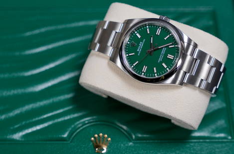
Sold2023Rolex op 36mm brand new watchRolex OP 36 mm brand new watch, green dial. Comes with original box, warranty card. Authentic.See Sold Price
Sold2021Chinese b/w charger plateChinese vintage blue and white floral porcelain charger plate. H: 3" x 13" Estate of San Diego collector.See Sold Price
5 days LeftJasper52Partie Occidentale de l’Afrique. West Africa coast Canary islands BONNE 1788 mapUS$15
5 days LeftJasper52Partie Occidentale de l'Ancien Continent… W Africa Macaronesia. BONNE 1780 mapUS$30
5 days LeftJasper52Côte occidentale de l'Afrique. W Africa.Senegal Gambia rivers.D’ANVILLE 1751 mapUS$85
Featured5 days LeftJasper52Coste Occidentale d’Afrique…' Namibia South Africa Angola coast BELLIN 1746 mapUS$45
5 days LeftJasper52Coste Occidentale d’Afrique…' West Africa. Gulf of Guinea. BELLIN 1746 mapUS$55
5 days LeftJasper52Le Canal de Mosambique, l'Isle de Madagascar… Mozambique. Africa. BONNE 1788 mapUS$15
5 days LeftJasper52Carte de l'Afrique propre, de la Numidie… North Africa. LAPIE 1829 old mapUS$45
BonhamsBERNADIN DE SAINT PIERRE (JACQUES) A Voyage to the Isle of France, the Isle of Bourbon, and the ...£300
BonhamsLEVAILLANT (FRANÇOIS) Voyage dans l'intérieur de l'Afrique, par le cap de Bonne-Esp...£7,000
Jun 14DuMouchellesRigobert Bonne (French, 1727-1794) Hand Colored Engraving Ca. 18th Century, Les Etats Unis DeUS$50(1 bid)
5 days LeftJasper52Carte du Golfe de Guinée. Gulf of Guinea Nigeria Cameroon BELLIN/SCHLEY 1748 mapUS$45
5 days LeftJasper52Morocco Algeria. French & Spanish West Africa. Sahara sand dunes. TIMES 1956 mapUS$20
5 days LeftJasper52WEST AFRICA showing early explorers' routes & Mountains of Kong. SDUK 1844 mapUS$40
5 days LeftJasper52Guinea-Bissau Cacheu town Fortaleza de São José da Amura Preparing cassava 1745US$10
Featured5 days LeftJasper52COLONIES FRANÇAISES en AFRIQUE. Africa Sénégal Madagascar. LEVASSEUR c1850 mapUS$65
4 days LeftJasper52Title/Content of Map: Jamaica: Port Mosquito Coast, by Ferrer, 1818 Date Printed: 1818US$55
1 day LeftGold Coast Auctioneers17th-19th c. French Wall Art Collection Map City Sea Scapes Scenes etc.US$50
4 days LeftJasper521752 Robert de Vaugondy Map of Middle East and Ancient Empires -- Antiquor Imperiorum Tabula, in quaUS$140