Sold1939 New York World's Fair Official World's Fair Pictorial Map1939 New York Worlds Fair Official Worlds Fair Pictorial Map by Tony Sarg in very good to excellent condition as seen in the photos.See Sold Price
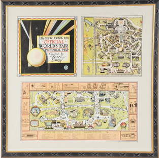
Sold2022Framed Tony Sarg 1939 World's Fair Pictorial MapTony Sarg (American, 1880-1942), "The New York 1939 Official World's Fair Pictorial Map Created by Tony Sarg 25¢" cover and Transportation Zone maps, three pieces matted and under glass in paintedSee Sold Price
Sold2018NYC World's Fair 1939 Walking Cane w Tony Sarg MapNew York World's Fair 1939 walking cane, containing a 13" X 13" fabric pull-out Tony Sarg color map of the fairgrounds, rare. 35" H. Map pulls 3/4 out; usage wear to grip finish; cane lacking originalSee Sold Price
Sold2024Tony Sarg (New York/England, 1882-1942) Oil/BoardTony Sarg (New York/England, 1882-1942) Original oil painting on canvas board [Interview at the Inland Empire Press Club, 3-25-41]. Measures 30 x 25 inches. Unframed, excellent condition. If lot is abSee Sold Price
Sold2017Tony Sarg's New York 1926Heading: Author: Sarg, Tony Title: Tony Sarg's New York Place Published: New York Publisher:Greenberg Publisher Date Published: 1926 Description: Unpaginated. 24 full-colorSee Sold Price
Sold2020Tony Sarg's New York, Lot of 4 PlatesLot of four color plates from Tony Sarg's New York, ca. 1927. On laid, sheets 12.5" x 9.75". One with two repairs to verso, as-is, refer to photos.See Sold Price
Sold2022(PICTORIAL MAPS -- MANUSCRIPT.) [New York City, Queens, 1776].(PICTORIAL MAPS -- MANUSCRIPT.) [New York City, Queens, 1776]. Pen and ink on heavy artist's stock. 15¾x21½ inches sheet size, wide margins; vertical fold at center. Np, mid-19th century ManSee Sold Price
Sold20181968 Bollmann Pictorial Map of New York City -- NewTitle/Content of Map: 1968 Bollmann Pictorial Map of New York City -- New York Picture and Street Map Date Printed: 1968, Braunschweig, Germany Cartographer: H Bollmann, published by Bollmann BildkartSee Sold Price
Sold20231938 R Taylor White Pictorial Map of New York -- New YorkTitle: 1938 R Taylor White Pictorial Map of New York -- New York Cartographer: Ruth Taylor White Year / Place: 1938, Boston Map Dimension (in.): 11.6 x 8.5 in. This is Ruth Taylor White's charming picSee Sold Price
Sold2022A RARE GRIBBROEK 1935 NATIVE AMERICAN POSTERRobert Gribbroek (1906-1971) historical pictorial map of New York State focused on its Native American tribes by Arthur Caswell Parker (1881-1955). Filled with portraits of prominent persons and sceneSee Sold Price
Sold2022FLICK, Alexander C. -- PAINE, Paul M. A Map of the History ...FLICK, Alexander C. -- PAINE, Paul M. A Map of the History of New York State. 1928. New York: R.R. Bowker Co. Historical pictorial map of New York with insets of Old New York, Niagara, Tip of Long IslSee Sold Price
Sold2023A Decorative Pictorial Map of The New York Worlds Fair by William L. Longyear (American, 1899-1980)A Decorative Pictorial Map of The New York Worlds Fair by William L. Longyear (American, 1899-1980). Framed. Designed and copyrighted by William Longyear. Lithographed in U.S.A by Polygraphic CompanySee Sold Price
Sold2021(PICTORIAL MAPS.) Robert J. Seymour; and Merritt L.(PICTORIAL MAPS.) Robert J. Seymour; and Merritt L. Ryder. Historical Westchester County. Color-printed pictorial map of Westchester County, New York. 22x17 inches sheet size, wide margins; old folds,See Sold Price
Sold2016Hardeen (Theodore Weiss). Two Hellzapoppin’ PlaybillsHardeen (Theodore Weiss). Two Hellzapoppin’ Playbills Featuring Hardeen. New York, 1940. Illustrated and pictorial wrappers. Pictorially illustrated. 4to and 8vo. Both very good. Accompanied by a HaSee Sold Price
Sold2024Pictorial Map of the United States, 1849PICTORIAL MAP OF THE UNITED STATES 1849. New York: Ensign and Thayer, [ca. 1849.] Sheet 44" x 32.25".*** An attractive hand-colored map providing a view of the United States as it was in the mid-19thSee Sold Price
Sold2022Fun Map of New Zealand. Wellington, ca. 1940. Pictorial map...Fun Map of New Zealand. Wellington, ca. 1940. Pictorial map of New Zealand, designed by the Charles Haines Advertising Agency of Wellington, and published by the New Zealand Government Tourist DepartmSee Sold Price
Sold2022Rare Tony Sarg Colored Map of New Hope, Pennsylvania 1941Rare Tony Sarg (1880-1942) Colored Map of New Hope, Pennsylvania 1941, depicting George Washington crossing the Delaware River among other local points of interest 19 in. x 25 in. Framed 27.5 in. x 33See Sold Price
Sold2017New York State MapNew York State Map ca. 1940 paper/linen/wood/metal 48.13" W x 1.75" D x 64.75" H Vintage New York social studies map manufactured by Denoyer-Geppert Co. of Chicago, IL, with working pull-down mechanisSee Sold Price
Sold2020Karamojo Safari by Bell 1949Karamojo Safari by W. D. M. Bell. 1949 with dust jacket price unclipped. Harcourt, Brace and Co., New York. 298 pp. with pictorial map endsheets. Measures 8.375 in. x 5.75 in. x 1.25 in. From a non-smSee Sold Price
Sold2022Marvelous pictorial map of the WorldHeading: (Maps) Author: Ensign & Thayer Title: World at One View Place Published: New York Publisher: Date Published: 1847 Description: Lithographed double-hemisphere map of theSee Sold Price
Sold2023[PICTORIAL MAPS]. Six travel maps and brochures. Includes: ...[PICTORIAL MAPS]. Six travel maps and brochures. Includes: RENTSCHLER, F. Historical Map of the Old Northwest Territory. 1937. New York: Farrar and Rinehart Inc. 23 x 17 ¼”. Folded. StoredSee Sold Price
Sold2024Tony Sarg "America's Puppet Master" Signed Elephant Doodle, Slabbed NM7Tony Sarg "America's Puppet Master" Signed Elephant Doodle, Slabbed NM7 A charming pencil illustration of an elephant signed by Tony Sarg. 1p, measuring 8.25" x 5.5", New York, n.d. On Sarg's personalSee Sold Price
Sold2023CHINA JEFFERSON (LOUISE E.) China. A Friendship Map, New York, Friendship Press, Inc., 1948CHINA JEFFERSON (LOUISE E.) China. A Friendship Map, pictorial colour printed map, numerous illustrations of famous sites, industries, and views, six portraits (including Sun Yat-sen, Chiang Kai-shekSee Sold Price
Sold2021Pictorial Map United States IndiansIndians of the U.S.A. Louise E. Jefferson. Friendship Press, New York: 1944. Novelty map showing native American tribes. Vintage color print. 22 1/2" x 34 1/2", overall 26" x 40".See Sold Price
BonhamsPOTTER (BEATRIX)The Story of a Fierce Bad Rabbit; The Story of Miss Moppet, FIRST EDITIONS, Lond...£10
2 days LeftRipley AuctionsNancy Grossman, New York (b. 1940), Untitled, 1965, ink on paper, 16 1/4"H x 13 1/4"W(sight), 20US$1,000(1 bid)
5 days LeftJasper521902 Cram Map of New York City [verso] Washington DC [verso] Baltimore -- New York [verso]US$60
5 days LeftJasper521933 Freedman Supervue Map of New York City -- Supervue Map of New York CityUS$120
5 days LeftMynt Auctions1940 New York Yankees Team Signed AL Baseball Joe Dimaggio & Joe MccarthyUS$740
3 days LeftBroward Auction GalleryErnest Peixotto (CA,NY,French,1869-1940) oil painting antiqueUS$60(3 bids)
Jun 06Freeman's | HindmanFAULKNER, William (1897-1962). [Snopes Trilogy]. The Hamlet. -- The Town. -- The Mansion. New York:US$150(1 bid)


![(PICTORIAL MAPS.) Tony Sarg. The New York [1940] First Image](https://p1.liveauctioneers.com/199/204863/103966381_1_x.jpg?height=300&quality=1&version=1621570993&width=300)
![(PICTORIAL MAPS.) Tony Sarg. The New York [1940] First Image](https://p1.liveauctioneers.com/199/204863/103966381_1_x.jpg?height=300&quality=95&version=1621570993&width=300)

![Tony Sarg (New York/England, 1882-1942) Oil/Board: Tony Sarg (New York/England, 1882-1942) Original oil painting on canvas board [Interview at the Inland Empire Press Club, 3-25-41]. Measures 30 x 25 inches. Unframed, excellent condition. If lot is ab](https://p1.liveauctioneers.com/5755/317056/170258052_1_x.jpg?height=310&quality=70&version=1706050319)


![(PICTORIAL MAPS -- MANUSCRIPT.) [New York City, Queens, 1776].: (PICTORIAL MAPS -- MANUSCRIPT.) [New York City, Queens, 1776]. Pen and ink on heavy artist's stock. 15¾x21½ inches sheet size, wide margins; vertical fold at center. Np, mid-19th century Man](https://p1.liveauctioneers.com/199/251723/130782406_1_x.jpg?height=310&quality=70&version=1655133895)


![Pictorial Map of the United States, 1849: PICTORIAL MAP OF THE UNITED STATES 1849. New York: Ensign and Thayer, [ca. 1849.] Sheet 44" x 32.25".*** An attractive hand-colored map providing a view of the United States as it was in the mid-19th](https://p1.liveauctioneers.com/3532/326332/175680404_1_x.jpg?height=310&quality=70&version=1713150771)


![[PICTORIAL MAPS]. Six travel maps and brochures. Includes: ...: [PICTORIAL MAPS]. Six travel maps and brochures. Includes: RENTSCHLER, F. Historical Map of the Old Northwest Territory. 1937. New York: Farrar and Rinehart Inc. 23 x 17 ¼”. Folded. Stored](https://p1.liveauctioneers.com/928/305275/163151901_1_x.jpg?height=310&quality=70&version=1697054833)


![1902 Cram Map of New York City [verso] Washington DC [verso] Baltimore -- New York [verso] (1 of 3)](https://p1.liveauctioneers.com/5584/331064/178466310_1_x.jpg?height=282&quality=70&version=1716924723)


![FAULKNER, William (1897-1962). [Snopes Trilogy]. The Hamlet. -- The Town. -- The Mansion. New York: (1 of 4)](https://p1.liveauctioneers.com/197/329405/177652455_1_x.jpg?height=282&quality=70&version=1715364568)


