Sold2022Pieter Goos (1616-1675) - Antique Map of Celtic Sea - Antique Sea ChartPieter Goos (1616–1675). Accurate nautical chart of the Celtic Sea oriented north to the left. The title cartouche depicts Nereus and his children, the Nereids, with cross staffs and an astrolaSee Sold Price
Sold2021GOOS, PIETER - Caribbean Islands Sea Chart 1666GOOS, Pieter (1616-1675) . Pascaert Vande Caribes Eylanden. Amsterdam: 1666. Engraved sea chart, period hand-colouring in outline. Sheet size: 21 1/2 x 25 inches. Minor age toning. Fine seventeenth ceSee Sold Price
Sold2017Jefferys: Antique Sea Chart Map of Coast of France 1774Map: 4th Chart of the Coast of France from Callais to Fecamp Date Printed: 1774 Cartographer: Jefferys, Thomas Size: 8 x 11 Condition: Very good Uniformly browned chain-laid paper. Strong impression.See Sold Price
Sold2018Antique Sea Chart Map of English Channel, 1914Title/Content of Map: 'The English Channel; Inset Newport; Dover; Calais; Tilbury; Brest; Cherbourg; Le Havre; Plymouth Sound; Southampton; Portsmouth; London Docks' sea chart. Ports lighthouses mailSee Sold Price
Sold2024Puerto Rico Antique Maps (3)Group of 3 antique folding map sea charts. One of Puerto Rico. Another of San Juan Harbor. The third a composite including Mayaguez Bay. Washington, D.C.: 1899. All fold as issued.See Sold Price
Sold2018Lootsman / Jacobsz: Antique Sea Chart of Brazil, 1662Title/Content of Map: Pascaerte van Brasil van Rio de Maranhaon tot Rio de la Plata . . . Date Printed: 1662 Cartographer: Lootsman/Jacobsz Size: 21.5" x 16.5" Rare sea chart of Brazil, one of the earSee Sold Price
2017van Keulen: Antique Sea Chart of South Hispaniola, 1682Map: Pas-kaart Van de Zuyd-Kust van Espanjola Cartographer: van Keulen Place & Date: Amsterdam / 1682 Size: 23" x 20" Condition: outline color (wash in cartouche); top margin trimmed close; light overSee Sold Price
Sold20191794 Sea Chart of South Part Sumatra 18th Century Mapa very rare 18th century antique sea chart. This is an uncolored copper plate engraving. Image measures 24\" x 32.5\". This map has been matted and is ready for framing. A stunning chart of the southeSee Sold Price
Sold2017Thomson: Antique Chart Map of Mediterranean Sea, 1817Chart of the Mediterranean Sea. Bay & roads of Marseilles. The harbour of Genoa. Plan of the Rock and Bay of Gibraltar, shewing the position of the combined fleet and attack of the battering ships inSee Sold Price
Sold2018Mount & Page: Antique Map of Palermo in Sicily, 1747Title/Content of Map: 'The haven of Palermo in Sicily' sea chart & town plan Date Printed: 1747 Image Size: Approx 11.0 x 23.0cm, 4.25 x 9 inches (Medium) Type: Antique 18th century copperplate map CoSee Sold Price
Sold2023Eastern Europe sea chart Ports Lighthouses mail route Black Sea Baltic 1918 mapTITLE/CONTENT OF MAP: 'Eastern European Ports and Waterways' DATE PRINTED: 1918 IMAGE SIZE: Approx 49.0 x 34.0cm, 19.25 x 13.5 inches (Large) TYPE: Antique colour maritime map chart; Scale 1:20,000,00See Sold Price
Sold2024Pacific Ocean sea chart. Ports lighthouses mail routes dockyards LARGE 1918 mapTITLE/CONTENT OF MAP: 'The Pacific Ocean' DATE PRINTED: 1918 IMAGE SIZE: Approx 49.0 x 69.0cm, 19.25 x 27.25 inches (Large); Please note that this is a folding map. TYPE: Antique colour maritime map cSee Sold Price
Sold2023Pacific Ocean sea chart. Ports lighthouses mail routes dockyards LARGE 1916 mapThe Pacific Ocean' by George Philip & Son Ltd (1916). Antique colour maritime map chart; Scale 1:40,000,000, 49.0 x 69.0cm, 19.25 x 27.25 inches; Please note that this is a folding map. Description: TSee Sold Price
Sold2024LARGE REPRO 19TH C. WHALING CHART; SOUTH CHINA SEAReproduction of an antique map. Two sheets, joined. Dimensions: (Frame) H 55.5" x W 45.5" Condition: Not examined out of frame. Intentionally antiqued; with spots of soiling, creases, a few tears andSee Sold Price
Sold2022Antique Map Ireland Correct Chart St George's ChannelA Correct Chart of St. George's Channel and the Irish Sea, including all of the coast of Ireland and the West Coast of Great Britain from Cantire to Portland Isle. It indicates it is From the latest aSee Sold Price
Sold2017Antique Nautical Chart of West Mediterranean SeaMap: Old nautical chart of the west Mediterranean Sea Subtitle: Mediterranean Sea, Gibraltar to Alicante, Cape Spartel to Cape Ferrat from Spanish and French Government Charts to 1877. Creator: BritisSee Sold Price
Sold2017Mount & Page: Antique Coast Profile of Ireland, 1749Title/Content of Map: '[A description of the sea coast of Ireland]' The following places are shown or referred to on the coastal profile chart: Galloway (Galway) Aran Islands Limerick Date Printed: 17See Sold Price
Sold2018Antique 1856 US Coastal Survey of Martha's VineyardTitle/Content of Map: 1856 US Coastal Survey of Martha's Vineyard amd Nantucket Area in Massachusetts -- Preliminary Chart of Part of the Sea Coast of Massachusetts from Saughkonnet River to PlymouthSee Sold Price
Sold20201666 Pas-Caart van Guinea en de Custen daer aen gelegenThis is an authentic antique map of the western coast of Africa. The map was published by Pieter Goos in his atlas De Zee-Atlas, Ofte Water-Weereld… out of Amsterdam. With an easterly orientatioSee Sold Price
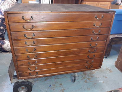
Sold2020Antique Map Architect Blue Print Sea Captain Chest 9 drAntique Map Architect Blue Print Sea Captain Chest 9 drawers custom made flat file cabinet for sea captain architect or blue prints,Maps, 9 drawers all on roller glides drawers work great very good coSee Sold Price
Sold2018Antique Tourist Map Carmel, CA c1930sAntique Tourist map of Carmel-By-The-Sea, CA c1930s. Has crease marks. Excellent condition. 28"h x 21"w. Frame 29.5"h x 22.5"w. Spend $5000 or more at this auction and all of your SHIPPING IS FREE wiSee Sold Price
Sold2017De Wit Portolan Sea Chart of EuropeTotius Europae Victoria... Frederic De Wit (1630-1706). Engraved map with original hand color. Amsterdam, 1675. 20 x 35 1/2 inches sheet, 27 1/2 x 43 inches framed. “The most striking and decorativeSee Sold Price
Sold2017Hondius: Antique Map of the Western Hemisphere, 1630Title/Content of Map: Western Hemisphere by H Hondius with sea monsters Date Printed: c1630-1634 Cartographer: Henricus Hondius Material/Medium: Paper Size: Approx 17" x 21" Magnificent Map. PublishedSee Sold Price
Sold2018Three Antique Mapswith The Countries and Islands Of The South Sea Company, 25 3/4" x 19 3/4" (sight) America Meridio Nalis, 15" x 20" (sight) Hispaniae, Novae Sivae, 14 1/2" x 20" (sight)See Sold Price
Featured5 days LeftJasper52Chart of the Sea Coasts of England, Flanders & Holland. MOUNT & PAGE 1758 mapUS$420
5 days LeftJasper52A Chart of the Sea Coast from England to the Streights. MOUNT & PAGE 1758 mapUS$500
5 days LeftJasper52Scandinavia Russia sea chart. Ports lighthouses. Arctic Ocean Bothnia 1918 mapUS$20
5 days LeftJasper52North Sea sea chart. Ports lighthouses mail routes. UK Norway &c LARGE 1952 mapUS$40
5 days LeftJasper52Scandinavia Russia sea chart. Ports lighthouses. Arctic Ocean Bothnia 1916 mapUS$20
5 days LeftJasper52Scandinavia Russia sea chart. Ports lighthouses. Arctic Ocean Bothnia 1952 mapUS$25
5 days LeftJasper52Spain, Portugal & Western France ports sea chart. Bordeaux Lisbon LARGE 1952 mapUS$35
5 days LeftJasper52Baltic Sea sea chart. Ports lighthouses mail routes dockyards. LARGE 1959 mapUS$25
5 days LeftJasper52Eastern Mediterranean & Black Sea chart. Ports lighthouses mail. LARGE 1927 mapUS$35
5 days LeftJasper52Spain, Portugal & Western France ports sea chart. Bay of Biscay. LARGE 1927 mapUS$35
5 days LeftJasper52Eastern Europe sea chart Ports Lighthouses mail route Black Sea Baltic 1916 mapUS$40
Featured5 days LeftJasper52Baltic Sea sea chart. Ports lighthouses mail routes dockyards. LARGE 1952 mapUS$40
5 days LeftJasper52Western Mediterranean sea chart. Ports lighthouses mail routes. LARGE 1959 mapUS$45
5 days LeftJasper52Eastern Mediterranean & Black Sea chart. Ports lighthouses mail. LARGE 1959 mapUS$45
5 days LeftJasper52North Sea sea chart. Ports lighthouses mail routes. UK Norway &c LARGE 1959 mapUS$45
5 days LeftJasper52Spain, Portugal & Western France ports sea chart. Bordeaux Lisbon LARGE 1959 mapUS$60
5 days LeftJasper52Scandinavia Russia sea chart. Ports lighthouses. Arctic Ocean Bothnia 1959 mapUS$60
5 days LeftJasper52Chart of the Mediterranean Sea. Marseilles Genoa Gibraltar. THOMSON 1817 mapUS$260
5 days LeftJasper52The Baltic or East Sea, including Gulfs of Botnia & Finland FADEN/NEALE 1803 mapUS$160
5 days LeftJasper52North Sea & Baltic. Cables Wireless Stns Land visibility Shipping lines 1952 mapUS$40


![Mount & Page: Antique Coast Profile of Ireland, 1749: Title/Content of Map: '[A description of the sea coast of Ireland]' The following places are shown or referred to on the coastal profile chart: Galloway (Galway) Aran Islands Limerick Date Printed: 17](https://p1.liveauctioneers.com/5584/110608/56777156_1_x.jpg?height=310&quality=70&version=1507840413)