Sold2022Pieter Goos (1616-1675) - Antique Map of Celtic Sea - Antique Sea ChartPieter Goos (1616–1675). Accurate nautical chart of the Celtic Sea oriented north to the left. The title cartouche depicts Nereus and his children, the Nereids, with cross staffs and an astrolaSee Sold Price
Sold2021GOOS, PIETER - Caribbean Islands Sea Chart 1666GOOS, Pieter (1616-1675) . Pascaert Vande Caribes Eylanden. Amsterdam: 1666. Engraved sea chart, period hand-colouring in outline. Sheet size: 21 1/2 x 25 inches. Minor age toning. Fine seventeenth ceSee Sold Price
Sold2017De Wit Portolan Sea Chart of EuropeTotius Europae Victoria... Frederic De Wit (1630-1706). Engraved map with original hand color. Amsterdam, 1675. 20 x 35 1/2 inches sheet, 27 1/2 x 43 inches framed. “The most striking and decorativeSee Sold Price
Sold2024Engraving After Adriaen van Ostade, Couple Dancing in a TavernEngraving After Adriaen van Ostade (Dutch 1610-1685) Couple Dancing in a Tavern, copper engraving by Jonas Suyderhoef (Dutch 1613-1686), published by Pieter Goos, (Dutch 1616-1675) the print c. 1633-8See Sold Price
Sold2018c. 1650 Map: Mar del Zur Hispanis Mare PacificumHistoric Maps c. 1650 Hand-Colored Map "Mar del Zur Hispanis Mare Pacificum" by Joannes Jansson with California as an Island Earliest Pacific Sea Chart of the to Appear in a Dutch Atlas c. 1650, Hand-See Sold Price
Sold2023De Eylanden van Pehou' by VAN KEULEN. Penghu Islands Taiwan. VOC chart 1753 mapTitle: De Eylanden van Pehou' by VAN KEULEN. Penghu Islands Taiwan. VOC chart 1753 map Description: De Eylanden van Pehou' by Johannes van Keulen (1753). Early 18th century Dutch sea chart with old coSee Sold Price
Sold2022Dudley Sea Chart of DenmarkDUDLEY, Sir Robert (1574-1649). [Denmark] Carta particolare che comincia con il gran fiume Albis e contene parte dell mare Baltico e Ientrata al sondo di Danemarca... Engraved map. Florence, 1646.20 7See Sold Price
Sold2022Dudley Sea Chart of ArgentinaDUDLEY, Sir Robert (1574-1649). [Argentina] Carta particolare della costa di America Australe che comincia al C. di Matas sin al C. di Galegos. Engraved map. Florence, 1646. 20 7/8" x 16 1/8" sheet. SSee Sold Price
Sold2022LARGE ARCHITECTS PRINT / MAP / CHART CABINETFantastic very large Architectural draftsman/chart/map/print flat file - George III-Style mahogany with satinwood inlay, inset tooled leather top. 8 Drawer over 4 drawer. from the Audubon Gallery, KinSee Sold Price
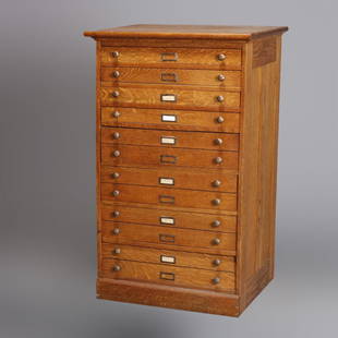
Sold2020Eight Drawer Oak Map, Art or Print File Cabinet, C 1910An antique map, art or print fining cabinet offers oak construction with eight drawers, brass pulls throughout, c1910. Measures- 45.5" H x 28" W x 22.75" D. ***IN-HOUSE SHIPPING & DELIVERY QUICK QUOTESee Sold Price
Sold2024Matthaus Merian 1627 Antique Map Engraving "Virginia" from Theodore de Bry's "Grand Voyages" #1Antique 1627 map of Virginia by Matthaus Merian after John Smith's 1612 map, from Theodore de Bry's "Grand Voyages". Please see "The Philidelphia Print Shop" sheet shown in final photo. Good conditionSee Sold Price
Sold2021Antique Coast Survey Map of the Atchafalaya BayAntique Coast Survey Map of the Atchafalaya Bay , "Preliminary Chart of Atchafalaya Bay Louisiana... A.D. Bache, Superintendant", 1858, lithograph, with later hand-coloring, sight 24 1/2 in. x 31 1/4See Sold Price
Sold2023Collection of Antique Prints "Cities of the World"Antique prints and etchings depicting "Cities of the World" - including Harper's Weekly illustrations, landscapes, antique maps, depictions of notable landmarks and famous cities such as Paris, New YoSee Sold Price
Sold2024De Jode, Rare, pub. 1593 - Map of the Holy Land (Descriptio Et Situs Terrae Sanctae Alio NomineThis map of the Holy Land is entitled Descriptio Et Situs Terrae Sanctae Alio Nomine Palestina Multis Preclaris Historys Et Miraculis Utriusque Testamenti A Christo Salvatore nobilitata. The map is beSee Sold Price
Sold2023Seutter - Map of North America including Great Lakes, Florida, Virginia, New England, Mexico, WestThis engraving is from a composite atlas presented by the Homann Heirs. Many of the maps in the collection were completed by J. B. Homann, Homann Erben, M. Seutter, and T. C. Lotter. The maps were oriSee Sold Price
Sold2016Map of Bermuda, by Hondius 1633Map of Bermuda, by Hondius 1633. Original hand colored copper engraving. Showing the "tribes" that were granted by the gentleman onboard the shipwreck that force the European settlement of the island.See Sold Price
Sold2024De Jode, Rare, pub. 1593 - Map of Kingdom of Napoli, Italy (Neapolitani Regni exacta ac diligensThis truly significant map is from one of the rarest atlases ever published, Gerard and Cornelis de Jode's Speculum orbis Terrae. The work was published in Antwerp in 1593 by Arnold Coninx for the widSee Sold Price
Sold2024Blaeu's Tooneel des Aerdrycx - Fifth Volume with 55 Engraved MapsThis remarkable fifth volume of 55 maps with original hand-coloring is is Jan & Willem Blaeu's Tooneel des Aerdrycx, oft Nieuwe Atlas ? Vyfde Deel or Theatrum Orbis Terrarum, Dutch edition. This was pSee Sold Price
Sold2022Ortelius, Abraham Islandia [Iceland]Ortelius, Abraham Islandia [Iceland] [Antwerp, c.1590 or later]. Hand-coloured engraved map (platemark 33.5 x 48.5cm, sheet size 43.5 x 55.5cm), incorporating sea-monsters, polar bears and Hekla volcaSee Sold Price
Sold2024Antique Maps of LouisianaAntique Maps of Louisiana., maps from Capt. Marcy's book Exploration of the Red River of Louisiana, 1854, incl. "Map of the Country Upon Upper Red-River", 1854, 18 3/4 in. x 36 in.; and "Map of the CoSee Sold Price
Sold2021Haunted Mansion Imagineering Map Blueline Print.(Disneyland, 1969) A large and remarkable WED Imagineering blueline design print of the Haunted Mansion drawn by Imagineer Dan Williams. Dated in the print 04-3-69, the 1/8":1' scale Key Area & LocatiSee Sold Price
Sold2024EAST ASIA Chinese Empire Japan China Mongolia Soongaria Tibet. COLLINS 1873 mapTITLE/CONTENT OF MAP: 'Chinese Empire & Japan' DATE PRINTED: 1873 IMAGE SIZE: Approx 23.5 x 31.0cm, 9.25 x 12.25 inches (Large); Please note that this is a folding map. TYPE: Antique colour map CONDITSee Sold Price
Sold2023World: Captain Cook, Large Folio - A General Chart Exhibiting the Discoveries made by Captain JamesThis fascinating folio engraving is from Captain James Cook & James King's A Voyage to the Pacific Ocean, for making Discoveries in the Northern Hemisphere. To determine the Position and Extent of theSee Sold Price
Sold20241836 Map of Spain and PortugalAntique map of Spain and Portugal dated 1836, engraved and hand-colored French map of Spain and Portugal frame: 29.5 x 41 in. Shipping available for this lot through our partner 4CL; please requestSee Sold Price
2 days LeftJasper52Southern Africa Cape of Good Hope-Madagascar ADMIRALTY sea chart 1935 (1955) mapUS$60
2 days LeftJasper52South Namibia coast. Walvis Bay-Orange River ADMIRALTY sea chart 1881 (1954) mapUS$85
2 days LeftJasper52Gulf of Guinea. Ghana Togo Benin Nigeria. ADMIRALTY sea chart 1928 (1954) mapUS$120
4 days LeftTrillium Antique Prints & Rare BooksCluver & De L'Isle - Map of the Eastern Hemisphere (Europe, Asia, Africa and part of Australia)US$75
Crawford Family Auctions LLCFramed print of Map of Part of the Island of Hawaii & Sandwich Islands, w/COAUS$20
Jun 15Riverfront Auctions'1785 Bocage Map of the City of Athens in Ancient Greece' Par M. Barbié du BocageUS$5(1 bid)
4 days LeftTrillium Antique Prints & Rare BooksKohler & Weigel - Frontispiece with Globe and Sea Monster and GodUS$75
4 days LeftTrillium Antique Prints & Rare BooksMerian - Dance of Death (Image is man in one direction, Skeleton when flipped)US$50
2 days LeftJasper52Africae / Africa by Bertius / Langenes 1603 old antique vintage map plan chartUS$260
4 days LeftTrillium Antique Prints & Rare BooksCluver - 3 Engravings of Compass Rose & Scientific Charts & DiagramsUS$75
Featured12 hrs LeftJasper52Horse market, Cairo (A hot bargain). Etching after F.A. Bridgman (American, 1847 - 1928)US$140
4 days LeftTrillium Antique Prints & Rare BooksKohler & Weigel - Map of Louisiana Territory or Eastern United States (extends from New Mexico toUS$110(4 bids)
4 days LeftTrillium Antique Prints & Rare BooksSanson - Map of California as an Island, Mexico (Audience de Guadalajara)US$160(4 bids)
4 days LeftTrillium Antique Prints & Rare BooksKohler & Weigel - Map of Sicily and SardiniaUS$85(2 bids)
4 days LeftTrillium Antique Prints & Rare BooksSanson - Map of North America with California as an IslandUS$120(3 bids)


![Dudley Sea Chart of Denmark: DUDLEY, Sir Robert (1574-1649). [Denmark] Carta particolare che comincia con il gran fiume Albis e contene parte dell mare Baltico e Ientrata al sondo di Danemarca... Engraved map. Florence, 1646.20 7](https://p1.liveauctioneers.com/1968/250616/130196505_1_x.jpg?height=310&quality=70&version=1654190895)
![Dudley Sea Chart of Argentina: DUDLEY, Sir Robert (1574-1649). [Argentina] Carta particolare della costa di America Australe che comincia al C. di Matas sin al C. di Galegos. Engraved map. Florence, 1646. 20 7/8" x 16 1/8" sheet. S](https://p1.liveauctioneers.com/1968/250616/130196501_1_x.jpg?height=310&quality=70&version=1654190895)


![Ortelius, Abraham Islandia [Iceland]: Ortelius, Abraham Islandia [Iceland] [Antwerp, c.1590 or later]. Hand-coloured engraved map (platemark 33.5 x 48.5cm, sheet size 43.5 x 55.5cm), incorporating sea-monsters, polar bears and Hekla volca](https://p1.liveauctioneers.com/94/251108/130828919_1_x.jpg?height=310&quality=70&version=1655281539)


