Sold2022Polar regions in two double hemisphere projections.Title: Polar regions in two double hemisphere projections. 1862 by Johnson and Ward Date/Period: 1862 Materials: Steel plate engraved. Size: 19" x 14" 1862 from 'Johnson's New Illustrated Family AtlasSee Sold Price
Sold20191784 Two Double Hemisphere Maps ProjectionsTwo double hemisphere projections, one being a Stereographic map and the other with an Orthographic Projection, both published by Harrison and Co, London, 1784. Each Fine, measures 10 x 8”. Reserve:See Sold Price
Sold2023Planiglobii Terrestris Mappa Universalis Utrumqs Hemisphaerium Orient et OccidentaleNeuremberg: Homann Heirs, 1746. Double hemisphere map of the world, with four globes tangential to the hemispheres, showing earth from various angles in addition to the expected polar views. Two diagrSee Sold Price
Sold2022(POLAR.) Christoph Weigel. Facies Poli Arctici. [and] Facies Poli Antarctici.(POLAR.) Christoph Weigel. Facies Poli Arctici. [and] Facies Poli Antarctici. Together two double-page engraved charts of the globe's northern and southern hemispheres. Approximately 13½x15 incheSee Sold Price
Sold20231861. World in Double Hemisphere Projection. By Johnson and BrowningTitle: 1861. World in Double Hemisphere Projection. By Johnson and Browning Date/Period: 1861 Materials: Steel engraved Size: 26 x 18” 1861, by Johnson and Browning. From ‘New IllustratedSee Sold Price
Sold2023ENGRAVED DOUBLE HEMISPHERE WORLD MAPS BY ZURNERAdam Friedrich Zurner, 1679 to 1742, two engraved double-hemisphere world map Planisphaerium Terrestre cum utroque Coelesti Hemisphaerio, sive Diversa Orbis Terraquei, colored by a contemporary hand.See Sold Price
Sold2022ENGRAVED DOUBLE HEMISPHERE WORLD MAPS BY ZURNERAdam Friedrich Zurner, 1679 to 1742, two engraved double-hemisphere world map Planisphaerium Terrestre cum utroque Coelesti Hemisphaerio, sive Diversa Orbis Terraquei, colored by a contemporary hand.See Sold Price
Sold2016Polar Projection of Hemispheres, 1835Original steel engraving of Northern and Southern Hemispheres from the vantage point of the North and South poles, published by Thomas Bradford, Boston, 1835. Dimensions: 13" L x 15" W This item shipsSee Sold Price
Sold2021Double hemisphere world map with additionalTitle: Double hemisphere world map with additional projections. 1752 by Homann Heirs Date/Period: 1762 Materials: Copperplate engraved Size: 24 x 20 1/2 1762, by J. B. Homann & Homann Heirs, from "AtlSee Sold Price
Sold2022De Wit - Nova Orbis Tabula In Lucem Edita, MapFrederick De Wit (circa 1629-1706), Nova Orbis Tabula In Lucem Edita, A.F. De Wit, published by Covens and Mortier, Amsterdam, circa 1720, in two sheets, engraving on laid paper, double hemisphere vieSee Sold Price
Sold2023Siberia Or Northern Asia.Title: Siberia Or Northern Asia. Cartographer: WELLER, EDW. Publisher: BLACKIE & SON Publication Date: 1860 Height: 13.75 Width: 20 Polar projection. No.L. Large double-page map. Shows some topographySee Sold Price
Sold2021Map of the Polar Regions - Arctic DiscoveriesMap of the Polar Regions Showing Recent Discoveries With Mercator Map of the Eastern Hemisphere on verso Cartographer: George Franklin Cram Dated: Circa 1900See Sold Price
Sold2022North Carolina Federal Walnut Cupboard TopNorth Carolina Federal Walnut Cupboard Topprobably eastern region, early 19th century, yellow pine secondary, dovetailed case, applied molded cornice, two hinged double-paneled doors, interior with thSee Sold Price
Sold20191835 Hammond World Map -- The WorldTitle/Content of Map: 1835 Hammond World Map -- The World Cartographer: J Hammond Size: 11 x 17 in. A nice world map showing the Eastern and Western Hemispheres as well as polar projections and climatSee Sold Price
Sold2020Framed 1822 World Map, FrenchDated 1822 world map in frame. This map is hand colored and tilted Mappemomde (French for a map showing two hemispheres). This map is double matted in contemporary frame.Condition: very good conditionSee Sold Price
Sold2022A Double Bull with Two SnakesOrontes Region (?) 2nd mill. B.C..Light red clay with white and grey inclusions.. L. 11.3 cm. H. 7.4 cmBull with two heads and sturdy legs. In the middle of its back, two snakes writhe up a funnel witSee Sold Price
Sold2019South AmericaTitle: South America Prublication Date: 1771 Cartographer: PHINN, T. Size: 7Height - 8.75Width Additional Information: Book illustration map with polar projection. Cartouche lower left shows two colonSee Sold Price
Sold2017A Near Eastern lobed bronze mace headA Near Eastern lobed bronze mace head, c. 1000 – 500 BC, the cylindrical shaft with double grooves bordering crossing lines and two rows of rounded projections. L: 1 7/8 in (4.8 cm). Well-preservedSee Sold Price
Sold2018North Carolina Walnut Corner Cupboardsecond quarter of the 19th century, western region, yellow pine secondary, one part form, applied cornice with cut-out shaped central tear drop, two upper paneled doors above a single double panel dooSee Sold Price
Sold2022A Mesopotamian marble double 'eye' idolA Mesopotamian marble double 'eye' idol Tell Brak Region, circa 3500-3300 B.C. The plaque incised with two pairs of eyes, the body incised with zig-zags, indicating the limbs of two embracing figuresSee Sold Price
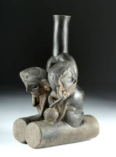
Sold2018Rare Chavin Double Fisherman Stirrup Vessel, TL TestedPre-Columbian, North Coast Peru, Jequetepeque River region, Chavin culture, Tembladera phase, ca. 1200 to 1000 BCE. A fabulous ceramic vessel depicting two fisherman sitting atop a pair of cylindricalSee Sold Price
Sold2019A SONG DYNASTY (960-1279) STYLE CELADON DOUBLE FISHA SONG DYNASTY (960-1279) STYLE CELADON DOUBLE FISH BOW, ATTRIBUTED TO THE LONGQUAN REGION, CHINESE, the flat rim over a dish centered by two fish, the exterior with petal form ridges or lobes, raisedSee Sold Price
Sold2020(CELESTIAL.) Cellarius, Andreas. Typus Aspectuum,(CELESTIAL.) Cellarius, Andreas. Typus Aspectuum, Oppositionum et Coniuntionum Etz in Planetis. Hand-colored double-page engraved celestial chart with a map of the world on a north-polar projection shSee Sold Price
2022Blaeu, Johannes (Netherlands, 1596-1673) "The New World Map" Double Hemisphere World Map C. 1664Nova et Accuratissima Totius Terrarum Orbis Tabula Translated "The New World Map", Hand Colored w/ Elaborately Decorated Spandrels.   Sight View 16" x 21-1/2", Overall View 21" x 25-1/2"See Sold Price
2 days LeftNadeau's Auction GalleryHarry Davis (British 1885-1970) for Royal Worcester Polar Bear Double Handled Porcelain VaseUS$5,000
2 days LeftNadeau's Auction GalleryHarry Davis (British 1885-1970) for Royal Worcester Polar Bear Double Handled Porcelain VaseUS$5,000
2 days LeftNadeau's Auction GalleryHarry Davis (British 1885-1970) for Royal Worcester Polar Bear Double Handled Porcelain VaseUS$5,000
May 23Forum AuctionsPolar.- Ross (Sir John) Narrative of a Second Voyage in Search of a North-West Passage and of a£75
Jun 07Freeman's | Hindman[MAP]. ORTELIUS, Abraham. Peregrinationis Divi Pauli Typus Corographicus. 1592.US$150
168 Lots AwayMa San AuctionA GROUP OF CHINESE METAL WARE HAIR PINS, EARLY 20TH CENTURY. Two double pronged pins with pierced£60


![(POLAR.) Christoph Weigel. Facies Poli Arctici. [and] Facies Poli Antarctici.: (POLAR.) Christoph Weigel. Facies Poli Arctici. [and] Facies Poli Antarctici. Together two double-page engraved charts of the globe's northern and southern hemispheres. Approximately 13½x15 inche](https://p1.liveauctioneers.com/199/251723/130782408_1_x.jpg?height=310&quality=70&version=1655133895)


![[MAP]. ORTELIUS, Abraham. Peregrinationis Divi Pauli Typus Corographicus. 1592. (1 of 2)](https://p1.liveauctioneers.com/197/329395/177650535_1_x.jpg?height=282&quality=70&version=1715364962)


