Sold2017Johnson: Antique Map Nebraska Dakota Idaho MontanaJohnson’s Nebraska, Dakota, Idaho and Montana, c1865. One of the earliest appearances of Wyoming on a map -- so early, it has not been added to the map title. Pre-dates Yellowstone. Wyoming is in aSee Sold Price
Sold2022Rare Walling's RR map of Upper Mississippi, 1868This rare map of the mid-continent is most noteworthy for its unusual configuration of Dakota Territory, pre-dating the formation of Wyoming. The map includes early appearances of Colorado Territory aSee Sold Price
Sold2021Rare c1780s U. S. map showing FrankliniaRare and unusual map of the United States showing early borders of various states. The seller has not been able to locate another copy of this map. The map appears to either be a source for, or copy oSee Sold Price
Sold2023Rare 19thc Census Map, U.S. Agricultural ProductionExtremely rare, original 1876 atlas map of the United States Agriculture Production - five agricultural maps (in inset form) of the production of wheat, hay, corn, cotton and tobacco. Each map distingSee Sold Price
Sold2017Bellin: Antique Map of Famous Louisiana Territory, 1740Title/Content of Map: Famous Louisiana territory or most of the US; RARE title type of the map. Date Printed: c 1740-70's Cartographer: J.N. Bellin & J.F. La Harpe Material/Medium: Paper Size: 9 3/4"See Sold Price
Sold20191819 RARE Jedidiah Morse Geography US Constitution1819 RARE Jedidiah Morse American Geography US Constitution Indians MAPS 2v SET Jedidiah Morse was an important and prominent geographer known for his American textbooks, books that earned him the namSee Sold Price
Sold20211864 American History INDIANS Mexico TEXAS Revolution1864 American History INDIANS Mexico TEXAS Revolutionary War US Map Willson Marcus Willson’s “American History” is a mid-19th-century compendium of the history of the United States from its earlSee Sold Price
Sold2023Map of the U. S. & Terr. – Rare 1st state, Mitchell 1860True first printing/first edition map from a rare atlas printed only for a short time in the early months of 1860. Samuel Augustus Mitchell, Jr. took over his father’s atlas publishing company iSee Sold Price
Sold20241907 Heimer Post Cards Ty Cobb Detroit Tigers Pennant Winners Pop 1/3 - RAREExtremely rare 1907 post card with the Detroit Tigers. Highlights Ty Cobb in one of the earliest appearances on a baseball card. PSA shows a total population of 2, with SGC having one example (offeredSee Sold Price
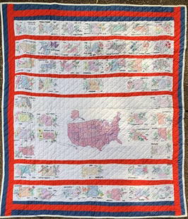
Sold2022Hand Embroidered Quilt of USA States w/ State Flower and State BirdExtremely rare hand-embroidered quilt of USA states including each state flower and state birds and each state induction date into the U.S. Map Completed 87"x84".See Sold Price
Sold2024Brown, John Randall – MentalistConsidered one of the first nationally famous mentalists in America and the first to perform a mind-reading act in the U.S. This rare flyer promotes his appearance in Norristown, PA October 26, 1876,See Sold Price
Sold20241869 American Emigrants Immigration Illustrated US State MAPS Railroad Alaska1869 American Emigrants Immigration Illustrated US State MAPS Railroad Alaska Frederick Goddards “Where to Emigrate and Why” is a rare, 19th-century informational treatise designed to give hinSee Sold Price
Sold20231814 map of Mexico showing Provincia Texas, M. CareyExtremely scarce and desirable map of Mexico or “New Spain” from Mathew Carey’s rare 1816 General Atlas. One of the earliest maps of Mexico published in America. Shows “ProvinSee Sold Price
Sold2024Rare 1823 map of Florida, Carey & LeaNice example of the rare 1823 edition of Carey & Lea's map of Florida, one of the earliest obtainable separate maps of Florida following its admission as a Territory in July of 1821. No counties existSee Sold Price
Sold2018RARE 1852 CASE TIFFANY & CO. MAP OF U.S.Dated 1851 to portrait of Washington, capital added 1852. Hand-colored engraving of folding map, West in territories. Dimensions: (Frame) H 27.25" x W 29.25", (Sight) H 22.75" x W 25" Condition: ColorSee Sold Price
Sold20211819 RARE Jedidiah Morse MAPS American Geography US1819 RARE Jedidiah Morse MAPS American Geography US Constitution Indians Europe Jedidiah Morse was an important and prominent geographer known for his American textbooks, books that earned him the namSee Sold Price
Sold20211849 Wilkes Pacific US Expedition FIJI MAP Pacific1849 Wilkes Pacific US Expedition FIJI MAP Pacific Islands Australia Illustrated The ‘Wilkes Expedition’ was one of the most important exploration voyages ever taken on by the United States. It heSee Sold Price
Sold20191850 US History & Topography Illustrated Maps Canals US1850 US History & Topography Illustrated Maps Canals US Sea-Ports Botany John Hinton John Howard Hinton was an English author. Among his many other works, he published “The History and Topography ofSee Sold Price
Sold20201834 1ed US History Illustrated Maps Canals Sea-Ports1834 1ed US History Illustrated Maps Canals Sea-Ports Hinton California Texas John Howard Hinton was an English author. Among his many other works, he published “The History and Topography of the UnSee Sold Price
Sold20181846 US History & Topography Illustrated Maps Canals US1846 US History & Topography Illustrated Maps Canals US Sea-Ports Botany John Hinton John Howard Hinton was an English author. Among his many other works, he published “The history and Topography ofSee Sold Price
Sold20181877 NEW YORK History Illustrated MAPS Steamboats US1877 NEW YORK History Illustrated MAPS Steamboats US Bridges 2v Martha Lamb “…three thousand miles from civilization, becomes within three centuries the seat of the arrogant metropolis of the WestSee Sold Price
Sold20191853 Santa Barbara, Calif., U. S. Coast SurveyReserve Reduced! One of the earliest obtainable maps of Santa Barbara. Map is centered on the town of Santa Barbara and shows roads, rivers, mountains, etc. The Mission and Ruined Village are shown inSee Sold Price
Sold20221856 Messages of US President 35 Atlas MAPS Florida1856 Messages of US President 35 Atlas MAPS Florida New York California Pierce Throughout the 19th-century, printed examples of Congress reports and messages of the United States Presidents were regulSee Sold Price
Sold20201887 Jules Verne Famous Travels & Travelers Voyage1887 Jules Verne Famous Travels & Travelers Voyage Exploration Illustrated MAPS “Reality provides us with facts so romantic that imagination itself could add nothing to them.” ― Jules VerneSee Sold Price
5 days LeftTrillium Antique Prints & Rare BooksDe L'Isle - Map of Louisiana and the Course of the Mississippi (Eastern America) (First AppearanceUS$240(2 bids)
Oct 27Schilb Antiquarian Rare Books1868 Civil War US Grant Campaigns Battle MAPS Vicksburg American PoliticsUS$25(2 bids)
5 days LeftTrillium Antique Prints & Rare BooksLewis - A View of the Butte des Morts Treaty Ground with the arrival of the Commissioners Gov. LewisUS$100(1 bid)
5 days LeftTrillium Antique Prints & Rare BooksAudubon, Imperial Folio - Common American Wild Cat. 1US$375
5 days LeftTrillium Antique Prints & Rare BooksLewis - Mish-Sha-Quat or the Clear Sky, A Chippeway ChiefUS$100
5 days LeftTrillium Antique Prints & Rare BooksBraun & Hogenberg, pub. 1575 - View of Besan?on, FranceUS$100
5 days LeftTrillium Antique Prints & Rare BooksBraun & Hogenberg, pub. 1575 - View of Augsburg, GermanyUS$100
5 days LeftTrillium Antique Prints & Rare BooksBraun & Hogenberg, pub. 1575 - Schw?bisch Hall on Kocher in GermanyUS$100
5 days LeftTrillium Antique Prints & Rare BooksBraun & Hogenberg, pub. 1575 - View of Bergen op Zoom, NetherlandsUS$100
Oct 26Sofe Design AuctionsRare Map with the marking of Sea of Korea/East Sea by Jacques Nicolas Bellin ? 18th Century.US$100
Oct 12JM Hobby Supply and Railroad Artifact AuctionsUS Railroad Association-1918 North Dakota Agricultural BrochureUS$30