Sold20201855 Savage World Geography History MAPS Coins Commerce1855 Savage World Geography History MAPS Coins Commerce Native American INDIANS Charles Savage’s ‘The World, Geographical, Historical, and Statistical’ is a mid-19th-century account of the histoSee Sold Price
Sold2020RARE world mapTitle: RARE world map Date/Period: 1596 Materials: Copperplate engraved Size: 14" x 10 1/4" Christ is shown on the left. The only world map of the century to show this. South America shows the westernSee Sold Price
Sold2018Extremely Rare world map in double HemisphereTitle/Content of Map: Extremely Rare world map in double Hemisphere projection Date: 1717 Size: 7.6x10.6†by Feuille published in 1717, Amsterdam. With California as a island. from one of the mostSee Sold Price
Sold2018Zurner: Antique Map of the World, 1700Title/Content of Map: World Map by Zurner Date Printed: c1700 Cartographer: A.F. Zurner Material/Medium: Paper Size: 20" x 21" Rare world Map. Hand colored engraved. Please note that this lot has a coSee Sold Price
Sold2020Arrowsmith, Aaron 1825 Rare World Hemisphere Map"World on Globular Projection" Steel Engraved Map Published 1825, London for "Outlines Of The World" by Aaron Arrowsmith. Rare. Outline hand color. Paper Size: 15 x 10.5 inch (37 x 27cm) Top margin slSee Sold Price
Sold2021Lochhead (Pub) 1811 Rare Map. World HemisphereCopper Engraved Map Published 1811 by William Lochhead, Berwick for "Modern Geography: And a Compendious General Gazetteer" Rare. Folds as issued. Paper Size: 17 x 11 inch (43 x 28cm) Some creasing. VSee Sold Price
Sold2023Lizars, Daniel 1831 LG Rare HC Map. World on Mercator's ProjectionLarge Folio Copper Engraved Map Published 1831-2 by John Hamilton, Successor to Daniel Lizars, Edinburgh for "The Edinburgh Geographical and Historical Atlas..." First Edition by Daniel Lizars. Very fSee Sold Price
Sold20191843 Folding Color German World Maps Europe Americas1843 Folding Color German World Maps Europe Americas Geography Austria RARE Three 19th-century world maps published in Vienna in 1843! Published for use in Austrian high schools, this atlas includes fSee Sold Price
Sold2018Bellin / la Harpe: Antique Map of the World, 1740Title/Content of Map: Rare large world Map Date Printed: 1740-1770's Cartographer: J.N. Bellin & J.F. La Harpe Material/Medium: Paper Size: 21 1/4" x 28" Copperplate engraved. From the 'Abrege de L'HiSee Sold Price
Sold20231810 American Gazetteer ATLAS Map Georgia Native Americans RARE Jedidiah Morse1810 American Gazetteer ATLAS Map Georgia Native Americans RARE Jedidiah Morse Jedidiah Morse was an important and prominent geographer known for his American textbooks, books that earned him the nameSee Sold Price
Sold20201798 American Gazetteer ATLAS Map Georgia Indians1798 American Gazetteer ATLAS Map Georgia Native Americans RARE Jedidiah Morse Jedidiah Morse was an important and prominent geographer known for his American textbooks, books that earned him the nameSee Sold Price
Sold2019Rare 1st ed. map of world diseases, c1848World map showing the spread of diseases across the globe in mid-19th century. Three inset maps show diseases in North America, the spread of cholera throughout the world and South Africa. Charts andSee Sold Price
Sold20191800 Geography ATLAS MAPS John Walker India Asia World1800 Geography ATLAS MAPS John Walker India Asia World Map John Walker’s ‘Elements of Geography’ is an incredibly late 18th-century English atlas known for its impressive folding maps. This atlaSee Sold Price
Sold20231810 Modern Geography America MAP + World Map Massachusetts Elijah Parish1810 Modern Geography America MAP + World Map Massachusetts Elijah Parish Elijah Parishs “New System of Modern Geography” is an early 19th-century American geography textbook. Published inSee Sold Price
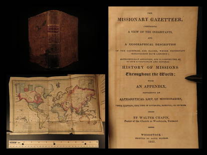
Sold20211825 1ed Missionary Gazetteer Chapin Slavery Indians1825 1ed Missionary Gazetteer Chapin Slavery Indians Illustrated Color World MAP ‘Missionary Gazetteer’ is a general history of missions throughout the world arranged alphabetically with an appendSee Sold Price
Sold201519TH & 20TH CENTURY MAPS AND BOOKS1.) 1887: With several fold out maps of the countries and a World Map: Ed. Robinson, Nugent, History of the World with all its Great Sensations Together with its Mighty and Decisive Battles and the RiSee Sold Price
Sold20211790 Geography Dictionary World MAPS Europe History1790 Geography Dictionary World MAPS Europe History French Laurence Echard Laurence Echards Geographic Dictionary is a rare, late 18th-century history of world. This book is organized much like a modeSee Sold Price
Sold20201761 George Anson Voyage Round the World MAPS Spain1761 George Anson Voyage Round the World MAPS Spain South America Brazil Peru George Anson was an 18th-century British Navy admiral who is noted for his important world voyage in which he circumnavigaSee Sold Price
Sold20201762 George Anson VOYAGE Round the World MAPS Spain1762 George Anson VOYAGE Round the World MAPS Spain South America Brazil Peru George Anson was an 18th-century British Navy admiral who is noted for his important world voyage in which he circumnavigaSee Sold Price
Sold20191764 George Anson Voyage Round the World MAPS South1764 George Anson Voyage Round the World MAPS South America Brazil Peru Chile George Anson was an 18th-century British Navy admiral who is noted for his important world voyage in which he circumnavigaSee Sold Price
Sold20241888 Civil War 1st ed Union General Sheridan Memoirs MAPS Native Americans Army1888 Civil War 1st ed Union General Sheridan Memoirs MAPS Native Americans Army “When the battle waged hottest, Sheridan was at his best—cool, exact, self-possessed, the dashing and brilliant leadSee Sold Price
Sold20181759 Voyages Geography MAPS Native American Indians1759 Voyages Geography MAPS Native American Indians Asia Alaska Canada Prevost The ‘General History of Voyages’ by abbe Prevost is one of the largest and most impressive collections of stories ofSee Sold Price
Sold2021Rare Jaeger LeCoultre Mappemonde Illuminated Deco DeskBrand: Jaeger Le Coultre Model: World Map Illuminated Table Clock Approximate Dimensions: 250mm height x 200mm diameter Base: Octagonal Marble Base MovemeSee Sold Price
Sold2017Launay World Map - Typus Orbis Terrarum, 1720Map: Launay World Map - Typus Orbis Terrarum Cartographer: C. Launay Date: ca. 1720 Size: 5 x 8 inches A quite rare, unique and charming double hemisphere map showing very rough approximations for theSee Sold Price
2 days LeftActivity AuctionsRare 1976**Franklin Mint*Sterling Silver**925/Gold World Map Old Art PieceUS$1,100
4 days LeftTrillium Antique Prints & Rare BooksSanson - Map of California as an Island, Mexico (Audience de Guadalajara)US$160(4 bids)
4 days LeftTrillium Antique Prints & Rare BooksSanson - Map of North America with California as an IslandUS$120(3 bids)
4 days LeftTrillium Antique Prints & Rare BooksSanson - Map of Moluccas, Celebes, & Gilolo (Halmahera)US$75
Jun 23Schilb Antiquarian Rare Books1977 JRR Tolkien 1st ed Silmarillion Lord of the Rings Middle Earth + MAPUS$155(7 bids)
4 days LeftConnoisseur AuctionsRare 19thc Colton Map, Argentine Republic, Chile, Uruguay, PataguayUS$50
4 days LeftTrillium Antique Prints & Rare BooksBraun & Hogenberg, pub. 1575 - View of Moscow, RussiaUS$150(2 bids)
4 days LeftTrillium Antique Prints & Rare BooksBraun & Hogenberg, pub. 1575 - Views of Italy: Urbino and SulmonaUS$100(1 bid)
4 days LeftTrillium Antique Prints & Rare BooksBraun & Hogenberg, pub. 1575 - View of Castle of Segeberg (Burg Segeberg) in Holstein, GermanyUS$100
4 days LeftTrillium Antique Prints & Rare BooksBraun & Hogenberg, pub. 1575 - View of Wroclaw (Breslau), PolandUS$110(2 bids)
4 days LeftTrillium Antique Prints & Rare BooksBraun & Hogenberg, pub. 1575 - View of Bristol, EnglandUS$100