Sold2020Arrowsmith, Aaron 1825 Rare World Hemisphere Map"World on Globular Projection" Steel Engraved Map Published 1825, London for "Outlines Of The World" by Aaron Arrowsmith. Rare. Outline hand color. Paper Size: 15 x 10.5 inch (37 x 27cm) Top margin slSee Sold Price
Sold2024Cooke, George 1801 Antique Map. World Hemispheres by ArrowsmithEngraved J. Lodge after Aaron Arrowsmith. Copper Engraved Map Published 1801-07 by Macdonald & Son, London for "Modern and Authentic System of Universal Geography" By George A. Cooke. Folds as issued.See Sold Price
Sold2021Lochhead (Pub) 1811 Rare Map. World HemisphereCopper Engraved Map Published 1811 by William Lochhead, Berwick for "Modern Geography: And a Compendious General Gazetteer" Rare. Folds as issued. Paper Size: 17 x 11 inch (43 x 28cm) Some creasing. VSee Sold Price
Sold2024Glasgow Geography 1825 Antique Map. World HemispheresCopper Engraved Map Published 1825, Glasgow for "The Glasgow Geography?" by Several Literary Gentleman. Folds as issued. .Paper Size: 16 x 10 inch (41 x 25cm) Some offsetting/toning. Minor wrinkles. SSee Sold Price
Sold2018Extremely Rare world map in double HemisphereTitle/Content of Map: Extremely Rare world map in double Hemisphere projection Date: 1717 Size: 7.6x10.6†by Feuille published in 1717, Amsterdam. With California as a island. from one of the mostSee Sold Price
Sold2022World.- Arrowsmith (Aaron) A New General Atlas... of all the Known Countries in the World, 1817World.- Arrowsmith (Aaron) A New General Atlas... of all the Known Countries in the World, engraved title, index and 53 maps, a few with hand-colouring, each interleaved with tissue, each map sheet apSee Sold Price
Sold2024Ptolemy & Magini, pub. 1620 - Double Hemisphere Map of the WorldThis early map engraving is from Claudius Ptolemaeus (Ptolemy) and Giovanni Antonio Magini's Geografia cio? Descrittione Universale della Terra Partita in due volumni, Nel Primo de' quali si contengonSee Sold Price
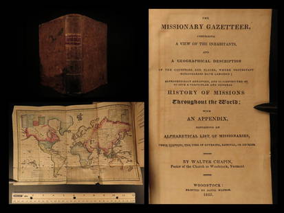
Sold20211825 1ed Missionary Gazetteer Chapin Slavery Indians1825 1ed Missionary Gazetteer Chapin Slavery Indians Illustrated Color World MAP ‘Missionary Gazetteer’ is a general history of missions throughout the world arranged alphabetically with an appendSee Sold Price
Sold2017Launay World Map - Typus Orbis Terrarum, 1720Map: Launay World Map - Typus Orbis Terrarum Cartographer: C. Launay Date: ca. 1720 Size: 5 x 8 inches A quite rare, unique and charming double hemisphere map showing very rough approximations for theSee Sold Price
Sold2024Arrowsmith & Lewis - Map of LouisianaThis engraved map is from Aaron Arrowsmith & Samuel Lewis's A New and Elegant General Atlas. Comprising all the new discoveries, to the present time... The work was published in Boston in 1812 by ThomSee Sold Price
Sold2024Arrowsmith & Lewis - Map of the United StatesThis engraved map is from Aaron Arrowsmith & Samuel Lewis's A New and Elegant General Atlas. Comprising all the new discoveries, to the present time... The work was published in Boston in 1812 by ThomSee Sold Price
Sold2024Arrowsmith & Lewis - Map of North AmericaThis engraved map is from Aaron Arrowsmith & Samuel Lewis's A New and Elegant General Atlas. Comprising all the new discoveries, to the present time... The work was published in Boston in 1812 by ThomSee Sold Price
Sold2023Thomson, John (Pub) 1825 Map. Eastern HemisphereCopper Engraved Map Published 1825 by John Thomson, Edinburgh for "The Edinburgh School Atlas" by N. R. Hewitt. Maps Engraved by Hewitt. Original Outline Hand Colour. Rare. Paper Size: 10.5 x 8 inch (See Sold Price
Sold2023Thomson, John (Pub) 1825 Map. Western Hemisphere (Faults)Copper Engraved Map Published 1825 by John Thomson, Edinburgh for "The Edinburgh School Atlas" by N. R. Hewitt. Maps Engraved by Hewitt. Original Outline Hand Colour. Rare. Paper Size: 10.5 x 8 inch (See Sold Price
Sold2023Thomson, John (Pub) 1825 Map. Chart of the WorldCopper Engraved Map Published 1825 by John Thomson, Edinburgh for "The Edinburgh School Atlas" by N. R. Hewitt. Maps Engraved by Hewitt. Original Outline Hand Colour. Rare. Paper Size: 10.5 x 8 inch (See Sold Price
Sold20211825 1ed Traveler Mexico Guatemala History Revolution1825 1st ed Traveler Mexico Guatemala History Revolutionary War Illustrated MAP Josiah Conder's “The Modern Traveller” is a remarkable 33 volume undertaking, covering much of the known world. ThisSee Sold Price
Sold20211825 Carte Geographique, Statistique et HistoriqueBy: Jean Alexandre BuchonDate: 1825 (Published) ParisDimensions: 18.5 x 25 inches (47 cm x 64 cm)This antique map is a rare example by Buchon depicting the state of North Carolina by itself, rather thSee Sold Price
Sold20211825 Carte Geographique, Statistique et Historique DuBy: Jean Alexandre BuchonDate: 1825 (Published) ParisDimensions: 18.5 x 25 inches (47 cm x 64 cm)This antique map is a rare example by Buchon depicting the state of Tennessee by itself, rather than toSee Sold Price
Sold20211825 Carte Geographique, Statistique et Historique LeBy: Jean Alexandre BuchonDate: 1825 (Published) ParisDimensions: 18.5 x 25 inches (47 cm x 64 cm)This antique map is a rare example by Buchon depicting the state of Ohio by itself, rather than togetheSee Sold Price
Sold20211825 Carte Geographique, Statistique et Historique DuBy: Jean Alexandre BuchonDate: 1825 (Published) ParisDimensions: 18.5 x 25 inches (47 cm x 64 cm)This antique map is a rare example by Buchon depicting the state of Maryland by itself, rather than togSee Sold Price
Sold20211825 Carte Geographique, Statistique et Historique DeBy: Jean Alexandre BuchonDate: 1825 (Published) ParisDimensions: 18.5 x 25 inches (47 cm x 64 cm)This antique map is a rare example by Buchon depicting the state of Pennsylvania by itself, rather thanSee Sold Price
Sold20211825 Carte Geographique, Statistique et Historique DuBy: Jean Alexandre BuchonDate: 1825 (Published) ParisDimensions: 18.5 x 25 inches (47 cm x 64 cm)This antique map is a rare example by Buchon depicting the state of Rhde Island by itself, rather thanSee Sold Price
Sold20211825 Carte Geographique, Statistique et Historique DuBy: Jean Alexandre BuchonDate: 1825 (Published) ParisDimensions: 18.5 x 25 inches (47 cm x 64 cm)This antique map is a rare example by Buchon depicting the state of Alabama by itself, rather than togeSee Sold Price
Sold20211825 Carte Geographique, Statistique et Historique DuBy: Jean Alexandre BuchonDate: 1825 (Published) ParisDimensions: 18.5 x 25 inches (47 cm x 64 cm)This antique map is a rare example by Buchon depicting the state of Kentucky by itself, rather than togSee Sold Price
5 days LeftJasper52Antique Felix Delamarche Vaugondy Mappemonde Double hemisphere world map 1838US$45
Jun 09Worthington Galleries19th c. Hemisphere World Map, Hohen und Tiefen der Erde in Lambert’s Zenithal-Projection vonUS$10
Jun 09Worthington GalleriesAntique Hand-colored Hemisphere Map Mappemonde Revue par E. Cortambert 1864US$25
2 days LeftTrillium Antique Prints & Rare BooksSanson - Map of the Philippines and Ladrones IslandsUS$75
2 days LeftTrillium Antique Prints & Rare BooksSanson - Map of the Sunda Islands, Sumatra, Java, & BorneoUS$75
Jun 23Schilb Antiquarian Rare Books1977 JRR Tolkien 1st ed Silmarillion Lord of the Rings Middle Earth + MAPUS$8(3 bids)