Sold2022Ruth Taylor White - Vintage Map - Caricature Map of California 1932 - United StatesThis amazingly detailed map Caricature Map of California 1932 year. You will receive the exact antique map in the photos. The condition is very good considering the age. See photo for condition. The eSee Sold Price
Sold2023West Indies/Caribbean. Pictorial map by Ruth Taylor White 1935 old vintageThis map locates the Panama Canal Zone, Porto Rico and Virgin Islands in Central America and the West Indies' by Ruth Taylor White (1935). Vintage colour pictorial map. The buyer should aware be thatSee Sold Price
Sold20231938 R Taylor White Pictorial Map of Utah -- UtahTitle: 1938 R Taylor White Pictorial Map of Utah -- Utah Cartographer: Ruth Taylor White Year / Place: 1938, Boston Map Dimension (in.): 11.6 x 8.5 in. This is Ruth Taylor White's charming pictorial mSee Sold Price
Sold20201938 R Taylor White Pictorial Map of Utah -- UtahTitle/Content of Map: 1938 R Taylor White Pictorial Map of Utah -- Utah Date: 1938, Boston Cartographer: Ruth Taylor White Size: 11.6 x 8.5 in. This is Ruth Taylor White's charming pictorial map, or cSee Sold Price
Sold2020RUTH TAYLOR WHITE CARTOGRAPHS MAPSMATTED ORIGINAL 1930'S WHIMSICAL PICTORIAL CARTOGRAPHS MAPS BY RUTH TAYLOR WHITE (3 PCS)See Sold Price
Sold2021Ruth Taylor White Hawaii Pictorial Maps (4)Island of Hawaii. Maui. Oahu. Kauai. Set of 4 Cartographs. Printed by The Paradise of the Pacific for the Hawaii Tourist Bureau, Honolulu. C. 1935. Ex library..See Sold Price
Sold20181938 R Taylor White Pictorial Map of Florida -- FloridaTitle/Content of Map: 1938 R Taylor White Pictorial Map of Florida -- Florida Date: 1938, Boston Cartographer: Ruth Taylor White Size: 11.6 x 8.5 in. This is Ruth Taylor White's charming pictorial mapSee Sold Price
Sold20181938 R Taylor White Pictorial Map of Colorado --Title/Content of Map: 1938 R Taylor White Pictorial Map of Colorado -- Colorado1938, Boston Cartographer: Ruth Taylor White Size: 8.5 11.6 in. This is Ruth Taylor White's charming pictorial map, or caSee Sold Price
Sold20181938 R Taylor White Pictorial Map of Kansas -- KansasTitle/Content of Map: 1938 R Taylor White Pictorial Map of Kansas -- Kansas Date: 1938, Boston Cartographer: Ruth Taylor White Size: 11.6 x 8.5 in. This is Ruth Taylor White's charming pictorial map,See Sold Price
Sold20191938 R Taylor White Pictorial Map of Arizona -- ArizonaTitle/Content of Map: 1938 R Taylor White Pictorial Map of Arizona -- Arizona Date: 1938, Boston Cartographer: Ruth Taylor WhiteSize: 11.6 x 8.5 in. This is Ruth Taylor White's charming pictorial map,See Sold Price
Sold20191938 R Taylor White Pictorial Map of Maine -- MaineTitle/Content of Map: 1938 R Taylor White Pictorial Map of Maine -- Maine Date: 1938, Boston Cartographer: Ruth Taylor White Size: 11.6 x 8.5 in. This is Ruth Taylor White's charming pictorial map, orSee Sold Price
Sold20201938 R Taylor White Pictorial Map of Montana -- MontanaTitle/Content of Map: 1938 R Taylor White Pictorial Map of Montana -- Montana Date: 1938, Boston Cartographer: Ruth Taylor WhiteSize: 11.6 x 8.5 in. This is Ruth Taylor White's charming pictorial map,See Sold Price
Sold2024Taylor, Ruth 1935 Vintage Cartoon Map. Western HemisphereVintage Lithograph Map Published 1935, Boston for "Our U. S. A. A Gay Geography" By Frank Taylor. Maps by Ruth Taylor. Paper Size: 12.5 x 9.5 inch (32 x 24cm) Tight margin as split from the larger sheSee Sold Price
Sold2024Vintage or Antique Grays Atlas Map of FloridaDescribed By:Sam 51903 NOD Title: Vintage or Antique Grays Atlas Map of Florida Description:Vintage Grays Atlas Map of Florida, framed. Hallmarks or Signature: N/ASee Sold Price
Sold2024Taylor, Ruth 1935 Vintage Cartoon Map. Eastern HemisphereVintage Lithograph Map Published 1935, Boston for "Our U. S. A. A Gay Geography" By Frank Taylor. Maps by Ruth Taylor. Paper Size: 12.5 x 9.5 inch (32 x 24cm) Tight margin as split from the larger sheSee Sold Price
Sold20181938 R Taylor White Pictorial Map of CaliforniaTitle/Content of Map: 1938 R Taylor White Pictorial Map of California -- California Date Printed: 1938, Boston Cartographer: Ruth Taylor White Size: 11.6 x 8.5 in. This is Ruth Taylor White's charmingSee Sold Price
Sold20221938 R Taylor White Pictorial Map of Texas -- TexasTitle: 1938 R Taylor White Pictorial Map of Texas -- Texas Cartographer: Ruth Taylor White Year / Place: 1938, Boston Map Dimension (in.): 11.6 x 8.5 in. This is Ruth Taylor White's charming pictorialSee Sold Price
Sold20211938 R Taylor White Pictorial Map of Texas -- TexasTitle: 1938 R Taylor White Pictorial Map of Texas -- Texas Cartographer: Ruth Taylor White Year / Place: 1938, Boston Map Dimension (in.): 11.6 x 8.5 in. This is Ruth Taylor White's charming pictorialSee Sold Price
Sold20201938 R Taylor White Pictorial Map of New Jersey -- NewTitle/Content of Map: 1938 R Taylor White Pictorial Map of New Jersey -- New Jersey Cartographer: Ruth Taylor White Year/Place: 1938, Boston Size: 11.6 x 8.5 in. This is Ruth Taylor White's charming pSee Sold Price
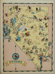
Sold20211938 R Taylor White Pictorial Map of Nevada -- NevadaTitle: 1938 R Taylor White Pictorial Map of Nevada -- Nevada Cartographer: Ruth Taylor White Year / Place: 1938, Boston Map Dimension (in.): 11.6 x 8.5 in. This is Ruth Taylor White's charming pictoriSee Sold Price
Sold20211938 R Taylor White Pictorial Map of Massachusetts --Title: 1938 R Taylor White Pictorial Map of Massachusetts -- Massachusetts Cartographer: Ruth Taylor White Year / Place: 1938, Boston Map Dimension (in.): 11.6 x 8.5 in. This is Ruth Taylor White's chSee Sold Price
Sold20201938 R Taylor White Pictorial Map of North Carolina --Title: 1938 R Taylor White Pictorial Map of North Carolina -- North Carolina Date: 1938, Boston Cartographer: Ruth Taylor White Size: 11.6 x 8.5 in. Additional Information: This is Ruth Taylor White'sSee Sold Price
Sold20201938 R Taylor White Pictorial Map of Georgia -- GeorgiaTitle/Content of Map: 1938 R Taylor White Pictorial Map of Georgia -- Georgia Cartographer: Ruth Taylor White Year/Place: 1938, Boston Size: 11.6 x 8.5 in. This is Ruth Taylor White's charming pictoriSee Sold Price
Sold20191938 R Taylor White Pictorial Map of Michigan --Title/Content of Map: 1938 R Taylor White Pictorial Map of Michigan -- Michigan Date: 1938, Boston Cartographer: Ruth Taylor White Size: 11.6 x 8.5 in. This is Ruth Taylor White's charming pictorial mSee Sold Price
2 days LeftJasper52WEST INDIES. West Indies in Dioceses; USA Bishoprics Church of England 1922 mapUS$10
6 days LeftAnnzstiques Auction HouseVintage Ollipop USA Filigree Ring brass white stone adjustableUS$38
2 days LeftJasper52GREATER ANTILLES. Cuba Hispaniola Jamaica Bahamas. Haiti Dominican Rep. 1947 mapUS$15
2 days LeftJasper52West Indies & Central America. Commercial. Agricultural products 1925 old mapUS$10
2 days LeftJasper52GUADELOUPE. Basse-Terre; Pointe-à-Pitre. St-Martin Saint-Barthélemy 1931 mapUS$15
2 days LeftJasper52GUADELOUPE. Basse-Terre; Pointe-à-Pitre. St-Martin Saint-Barthélemy 1938 mapUS$15
2 days LeftJasper52GUADELOUPE. Basse-Terre; Pointe-à-Pitre. St-Martin Saint-Barthélemy 1929 mapUS$20
2 days LeftJasper52Antique Solid & Heavy 14K Gold E.HOWARD & Co BOSTON watch c.1900 HAND ENGRAVEDUS$4,000