Sold2018Mitchell: Antique County Map of Florida, 1870County Map of Florida The beautifully detailed and colored county map of Florida from the 1870 edition of Mitchell's popular New General Atlas of the world. Framed by the vine motif border typical ofSee Sold Price
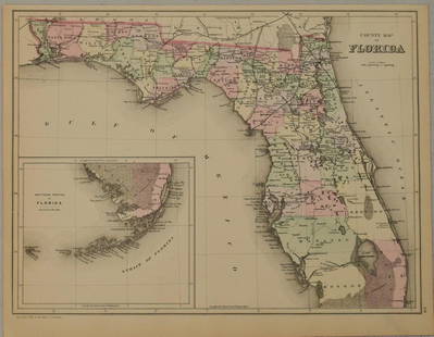
Sold2016Mitchell: County Map of Florida 1867Map: County Map of Florida Maker: Mitchell Size: 11 x 13.25 inches Counties in original wash color. Inset of Mobile, AL. No Reserve: This lot starts at $1 and has no reserve as a courtesy so that collSee Sold Price
Sold2018Mitchell: Antique County Map Illinois/Springfield, 1870Map: County Map of the State of Illinois Cartographer: S. A. Mitchell Place & Date: Philadelphia / 1870 Size: 10 3/4" x 13 5/8" Condition: full color; light overall age toning The beautifully detailedSee Sold Price
Sold2023Rare 1st state of Florida map from 1st printing of 1860 atlasFirst edition, first state of S. A. Mitchell Jr.'s County Map of Florida/County Map of South Carolina. Maps from Mitchell Jr’s first printing of his first New General Atlas are distinguished bySee Sold Price
Sold2017Mitchell: Antique County Map of Texas, 1870Map: County Map of Texas Cartographer: S. A. Mitchell Place & Date: Philadelphia / 1870 Size: 13 1/4" x 10 3/4" Condition: full color; light overall age toning The beautifully detailed and colored couSee Sold Price
Sold2018Mitchell: Antique County Map of Maine, 1870County Map of the State of Maine The beautifully detailed and colored county map of Maine from the 1870 edition of Mitchell's popular New General Atlas of the world. Framed by the vine motif border tySee Sold Price
Sold2018Mitchell: County Map of Kentucky & Tennessee, 1870Title/Content of Map: County Map of Kentucky and Tennessee Cartographer: S. A. Mitchell Place & Date: Philadelphia / 1870 Size: 13 3/8" x 9 3/4" Condition: full color; light overall age toning; slightSee Sold Price
Sold2019Samuel Augustus Mitchell (1790-1868), "County Map ofSamuel Augustus Mitchell (1790-1868), "County Map of Florida," 1867, Atlas, with an inset of Mobile, H.- 12 in., W.- 12 3/8 in.See Sold Price
Sold2019Samuel Augustus Mitchell (1790-1868), "County Map ofSamuel Augustus Mitchell (1790-1868), "County Map of Florida, North Carolina, South Carolina," 1860, H. - 12 1/4 in., W. - 15 3/8 in.See Sold Price
Sold20181887 Mitchell Map of Florida -- County Map of FloridaTitle/Content of Map: 1887 Mitchell Map of Florida -- County Map of Florida Date: 1887, Philadelphia Cartographer: S Mitchell Size: 10.7 X 14.3 in. Handsome county map of Florida. In this derivative mSee Sold Price
Sold20221876 Mitchell Map of Florida -- County Map of FloridaTitle: 1876 Mitchell Map of Florida -- County Map of Florida Cartographer: S Mitchell Year / Place: 1876 Philadelphia Map Dimension (in.): 10.6 x 13.5 in. Handsome county map of Florida. Virtually allSee Sold Price
Sold2017Mitchell: Antique County Map of Utah & Nevada, 1870[Utah, Nevada]. N. p: S. Augustus Mitchell, 1870s. The map was drawn and engraved by W. H. Gamble of Philadelphia. Coloured map. Approximately 11-3/4 x 14-/4 inches image area, one sheet, matted. FineSee Sold Price
Sold20181874 Mitchell Antique Map of FloridaTitle/Content of Map: 1874 Mitchell Map of Florida -- County Map of Florida Date Printed: 1874 Philadelphia Cartographer: S Mitchell Size: 10.6 X 13.5 Handsome county map of Florida. Virtually all ofSee Sold Price
Sold20181870 Mitchell Map of Minnesota -- County Map ofTitle/Content of Map: 1870 Mitchell Map of Minnesota -- County Map of Minnesota Date: 1870, Philadelphia Cartographer: S Mitchell Size: 13.8 x 11.5 in. This is nice county map of Minnesota. Great dealSee Sold Price
Sold20211883 Mitchell/Bradley Map of Florida -- County Map ofTitle: 1883 Mitchell/Bradley Map of Florida -- County Map of Florida Cartographer: Mitchell / Bradley Year / Place: 1883, Philadelphia Map Dimension (in.): 10.5 X 14.4 in. This is a rather handsome coSee Sold Price
Sold2023Samuel Augustus Mitchell 'County Map of...GA and AL'A Samuel Augustus Mitchell (American, 1792-1868) hand colored engraving titled 'County Map of the States of Georgia and Alabama' depicting the tri-state area of Georgia, Alabama and part of Florida anSee Sold Price
Sold2018Mitchell: County Map of PennsylvaniaReserve Reduced! The beautifully detailed and colored county map of Pennsylvania from the 1870 edition of Mitchell's popular New General Atlas of the world. The map is framed by the vine motif borderSee Sold Price
Sold2017Mitchell: Antique Map of Florida & South Carolina, 1860Map: 1860 Mitchell Map of Florida and South Carolina -- County Map of Florida [on sheet with] County Map of South Carolina Date Printed: 1860, Philadelphia Cartographer: S Mitchell Size: 9.1 x 10.6 inSee Sold Price
Sold20191860 Mitchell Map of Florida and South Carolina --Title/Content of Map: 1860 Mitchell Map of Florida and South Carolina -- County Map Of Florida [on sheet with] Map Of South Carolina Date: 1860, PhiladelphiaCartographer: S Mitchell Size: 10.8 x 13.2See Sold Price
Sold2019Two Copies of Samuel Augustus Mitchell (1790-1868), "Two Copies of Samuel Augustus Mitchell (1790-1868), " County Map of Arkansas, Mississippi, and Louisiana," 1870, hand colored, H.-15 1/8 in., W.- 23 1/8 in. (2 Pcs.)See Sold Price
Sold2021County map of FloridaTitle: County map of Florida Artist: S. Augustus Mitchell, Jr. Medium: Lithograph Dimensions: 10 1/2 x 13 1/4 Description: 1881 map of Florida, with inset of Mobile Reserve: $75.00 Shipping: DomeSee Sold Price
Sold20201860 Mitchell Map of Florida, South and North CarolinaTitle/Content of Map: 1860 Mitchell Map of Florida, South and North Carolina -- County Map of Florida on page with Map of South Carolina, on page with County Map of North Carolina Cartographer: S MitcSee Sold Price
Sold20231860 Mitchell Map of Florida, South and North Carolina -- County Map of Florida on page with Map ofTitle: 1860 Mitchell Map of Florida, South and North Carolina -- County Map of Florida on page with Map of South Carolina, on page with County Map of North Carolina Cartographer: S Mitchell Year / PlaSee Sold Price
Sold20211860 Mitchell Map of Florida, South and North CarolinaTitle: 1860 Mitchell Map of Florida, South and North Carolina -- County Map of Florida on page with Map of South Carolina, on page with County Map of North Carolina Cartographer: S Mitchell Year / PlaSee Sold Price
5 days LeftSimpson Galleries, LLC.J.H. Young (1792-1870) AN AMERICAN FEDERAL PERIOD MAP, "Mitchell's Travellers Guide Through theUS$500
Jun 14DuMouchellesWilliam H. Gamble (American, B. 1863) Hand Colored Engraving, Ca. 1863, "County Map of Michigan AndUS$50(1 bid)
4 days LeftHolabird Western Americana CollectionsAtlas Pages Stark Cty, OH & Townships . c1870-1900's. [180168]US$50
4 days LeftFreeman's | Hindman[HARDY, Thomas] -- HUTCHINS, John. The History and Antiquities of the County of Dorset by JohnUS$250
Jun 13Swann Auction Galleries(NEW YORK.) Ferdinand Mayer & Sons; [after Joseph H. Hidley?] Rensselaer Ville, N.Y.US$450
Jun 13Swann Auction Galleries(ENGLAND.) Robert Atkyns. The Ancient and Present State of Glocestershire. The Second Edition.US$1,100
4 days LeftHolabird Western Americana CollectionsTrinity County Mines (Wall) Map, 1894, Cowden, Johnson [177508]US$250
Jun 13Swann Auction Galleries(NORTH AMERICA.) Samuel Augustus Mitchell. New National Map, Exhibiting the United States with theUS$450


![Mitchell: Antique County Map of Utah & Nevada, 1870: [Utah, Nevada]. N. p: S. Augustus Mitchell, 1870s. The map was drawn and engraved by W. H. Gamble of Philadelphia. Coloured map. Approximately 11-3/4 x 14-/4 inches image area, one sheet, matted. Fine](https://p1.liveauctioneers.com/5584/107399/55057774_1_x.jpg?height=310&quality=70&version=1501794677)


![Mitchell: Antique Map of Florida & South Carolina, 1860: Map: 1860 Mitchell Map of Florida and South Carolina -- County Map of Florida [on sheet with] County Map of South Carolina Date Printed: 1860, Philadelphia Cartographer: S Mitchell Size: 9.1 x 10.6 in](https://p1.liveauctioneers.com/5584/109294/56069180_1_x.jpg?height=310&quality=70&version=1505338533)
![1860 Mitchell Map of Florida and South Carolina --: Title/Content of Map: 1860 Mitchell Map of Florida and South Carolina -- County Map Of Florida [on sheet with] Map Of South Carolina Date: 1860, PhiladelphiaCartographer: S Mitchell Size: 10.8 x 13.2](https://p1.liveauctioneers.com/5584/144953/73284299_1_x.jpg?height=310&quality=70&version=1562102885)


![Atlas Pages Stark Cty, OH & Townships . c1870-1900's. [180168] (1 of 6)](https://p1.liveauctioneers.com/2699/331495/178785794_1_x.jpg?height=282&quality=70&version=1717094933)


![[HARDY, Thomas] -- HUTCHINS, John. The History and Antiquities of the County of Dorset by John (1 of 2)](https://p1.liveauctioneers.com/197/329395/177650388_1_x.jpg?height=282&quality=70&version=1715364962)
![(NEW YORK.) Ferdinand Mayer & Sons; [after Joseph H. Hidley?] Rensselaer Ville, N.Y. (1 of 1)](https://p1.liveauctioneers.com/199/332329/179231821_1_x.jpg?height=282&quality=70&version=1717450360)


![Teton County, MT Map, Large, 1910 [166815] (1 of 3)](https://p1.liveauctioneers.com/2699/331495/178785760_1_x.jpg?height=282&quality=70&version=1717094933)


![Trinity County Mines (Wall) Map, 1894, Cowden, Johnson [177508] (1 of 4)](https://p1.liveauctioneers.com/2699/331495/178785752_1_x.jpg?height=282&quality=70&version=1717094933)


