Sold2023SCANDINAVIA.Shows early railways inc Oslo-Eidsvoll.Norway Sweden.LOWRY 1863 mapTITLE/CONTENT OF MAP: 'Sweden and Norway' The map shows early Scandinavian railway lines, including the first Norwegian railway between Oslo-Eidsvoll which had been completed in 1854. In Sweden it shoSee Sold Price
Sold2023Early Map of Tennessee, Daniel Smith, 1795A MAP OF THE TENNASSEE [sic] GOVERNMENT FORMERLY PART OF NORTH CAROLINA TAKEN CHIEFLY FROM SURVEYS BY GENL. D. SMITH & OTHERS, drawn by Daniel Smith, engraved by Joseph T. Scott, for "General Atlas FoSee Sold Price
Sold2022EARLY MAP "AMERICA"John Speede 1626, Thomas Bassett / Richard Chillwell, Abraham Goos; "The Description of America", hand colored, center fold, slight foxing, framed size 19" x 23 1/2", G-G+See Sold Price
Sold2022EARLY MAP OF BRITAINJohn Speede / Thomas Basett, bookplate "Sanon Heptarchy" on reverse, hand colored, center fold, slight toning, framed size 19" x 23 1/2", G-G+See Sold Price
Sold2022LARGE EARLY MAP"The Washington Map of The United States", 1861, approximate size 69 1/2" x 69", with early thin linen backingSee Sold Price
Sold2016Early Map: "A New Map Of North America...."Early map: "A New Map Of North America Showing its Principal Divisions....Dedicated To His Highness William Duke Of Gloucester...". Dated 1573. Sight 15" x 19 1/2".See Sold Price
Sold2017Framed Colored Engraved 17th C. World Map"Nova Totius Terrarum Sive Novi Orbis Tabula" Framed Colored Engraved 17th C. World Map by Willem Janszoon Blaeu - This interesting piece is an early world map created by Willem Janszoon Blaeu. The maSee Sold Price
Sold2022EARLY MAP OF AFRICA"Africae" "Newly Done into English John Speede / G. Humble 1626" engraved by Abraham Goos, bookplate "The Description of Africa" on reverse, hand colored; minor tear, foxing, toning, tape marks; frameSee Sold Price
Sold2022Payne/Low, Map of Tennessee Government, 1799A MAP OF THE TENNASSEE[sic] GOVERNMENT FROM THE LATEST SURVEYS, 1799, engraved for John Payne's NEW AND COMPLETE UNIVERSAL GEOGRAPHY, published by John Low, New York, 1799. This early copperplate engrSee Sold Price
Sold2018ANTIQUE HAND COLORED WORLD MAP WITH SCENIC CORNERS.ANTIQUE HAND COLORED WORLD MAP WITH SCENIC CORNERS ON EARLY LAID PAPER. IMAGE 22 3/4 X 19 1/4See Sold Price
Sold2022An early Santa Clara Pueblo blackware pottery vesselFourth-Quarter 19th Century Unsigned Possibly by Sara Fina Tafoya (1863-1949, Santa Clara Pueblo), the twin-handled jar with diagonally swirled ribs from the top of the handles to the bottom of theSee Sold Price
Sold2022Two Tiffany & Co. sterling silver cigarette boxesLate 20th/early 21st century Each marked for Tiffany & Co. sterling; further marked: Made in Italy Each box with wood lined interior, comprising one with an etched world map design and one with an iSee Sold Price
Sold2020Early United States Roll-Up MapEarly United States roll-up map. Published by J. H. Colton / New York / 1853. 44 1/2" x 36".See Sold Price
Sold2017Map of the AmericasEarly Hand colored French map of the Americas. Site 20.5" x 24"See Sold Price
Sold2022Plan of St. Andrews Links Booklet with MapEarly booklet with folding map Plan of Golf Courses, showing Old, New and Jubilee Courses. Robert Forgan & Son, Scotland ad inside front cover. Early manuscript note verso. Rare book pocket map cartogSee Sold Price
Sold2018After ''Letts's map of the city of Paris''Late 20th/early 21st century Letts, Son & Co. Limited, London Gicl_e Sight: 56.5" H x 80.5" WSee Sold Price
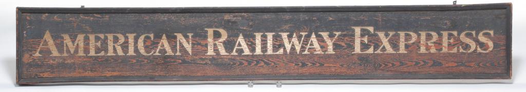
Sold2021"AMERICAN RAILWAY EXPRESS" SIGN.Late 19th-early 20th century. Single sided board with original black sanded ground and gilt letters. Molded frame trim. Weathered. 11"h. 71.5"w.See Sold Price
Sold2021R. Blome on His Majesty's Territories in America, 1687R. Blome on His Majesty's Territories in America, 1687 1st Edition with 7 Folding Morden Maps Inc. Carolina, Virginia, New York & Bermuda BLOME, Richard. The Present State Of His Majesties Isles aSee Sold Price
Sold2022Louis C. Tiffany Furnaces Inc. American, Early 20th Century Art Deco Desk SetLouis C. Tiffany Furnaces Inc. American, Early 20th Century Art Deco Desk Set bronze, enamel Art Deco set marked 'Louis C. Tiffany Furnaces Inc. / Favrile' and numbered; Ninth Century frame marked 'TiSee Sold Price
Sold2023Steve Jobs Signed/Drawn Apple Computer 1 SchematicThis auction presents a remarkable technological and corporate history piece: an original Apple Computer 1 schematic drawn and signed by Steve Jobs on very early Apple Computer Inc. stationery. This eSee Sold Price
Sold2021Dutch Nicolaes Visscher I Map of New Amsterdam, ca 1690Nicolaes Visscher I. Map of Northeast with Early View of New York City. Ca. 1690 to 1729. A finely hand-colored example of Nicolaes Visscher I's illustrated map of the Northeast of America with an insSee Sold Price
Sold2021Manuscript Map of the Holy Land, early 18th Century[Manuscript map of the Holy Land] Pencil, ink, and watercolor on faux vellum with horizontal and vertical folding creases (8 segments) and no mounting guard; pencil grid visible in upper left and righSee Sold Price
Sold2022(BRITISH EMPIRE.) George Philip & Son, Ltd.; and The London Geographical Institute. Navy League Map(BRITISH EMPIRE.) George Philip & Son, Ltd.; and The London Geographical Institute. Navy League Map of the British Empire. Oversize chromolithograph map of the world delineating early 20th-century BriSee Sold Price
Sold2020A BOXED ROLEX TWO TONE DIAMOND EMBELLISHED DATE JUSTA BOXED ROLEX TWO TONE DIAMOND EMBELLISHED DATE JUST WRISTWATCH. 3.5 cm wide, strap 15 cm inc claspSee Sold Price
Jun 02Schilb Antiquarian Rare Books1899 STONEWALL JACKSON Civil War Confederate Military + Wolseley PROVENANCEUS$2(2 bids)
370 Lots AwayPotter & Potter AuctionsBOLLMANN, Hermann (1911 – 1971). Map of New York City. 1962.US$100(1 bid)


![Early Map of Tennessee, Daniel Smith, 1795: A MAP OF THE TENNASSEE [sic] GOVERNMENT FORMERLY PART OF NORTH CAROLINA TAKEN CHIEFLY FROM SURVEYS BY GENL. D. SMITH & OTHERS, drawn by Daniel Smith, engraved by Joseph T. Scott, for "General Atlas Fo](https://p1.liveauctioneers.com/525/272425/142901899_1_x.jpg?height=310&quality=70&version=1671337478)


![Payne/Low, Map of Tennessee Government, 1799: A MAP OF THE TENNASSEE[sic] GOVERNMENT FROM THE LATEST SURVEYS, 1799, engraved for John Payne's NEW AND COMPLETE UNIVERSAL GEOGRAPHY, published by John Low, New York, 1799. This early copperplate engr](https://p1.liveauctioneers.com/525/230966/119655004_1_x.jpg?height=310&quality=70&version=1640205832)


![Manuscript Map of the Holy Land, early 18th Century: [Manuscript map of the Holy Land] Pencil, ink, and watercolor on faux vellum with horizontal and vertical folding creases (8 segments) and no mounting guard; pencil grid visible in upper left and righ](https://p1.liveauctioneers.com/1968/225974/116712048_1_x.jpg?height=310&quality=70&version=1636655147)


