Sold2022Sea Chest with Map-of-the-World CoveringSea chest with map-of-the-world covering, having leather strap, 20" H x 40" W x 20" D. Provenance: West Palm Beach, Florida estate.See Sold Price
Sold2019MAP - Mexico & Cuba. JefferysSoutheastern Mexico & Western Cuba. Jefferys/Sayer, The Coast of Yucatan from Campeche to Bahia del Ascension; with the West End of Cuba, 1775 (dated). Hand Color. Fine sea chart covering from the YucSee Sold Price
Sold2018Tropical World Map Nesting Box ChestTropical Nautical Tropical Decor Nesting Box. 2 boxes.See Sold Price
Sold2019Balkans.- Adriatic Sea .- Ruscelli (Girolamo) TavolaBalkans.- Adriatic Sea .- Ruscelli (Girolamo) Tavola Nuova di Schiavonia, map covering the Adriatic coastal region of the Balkans, engraving with early hand-colouring on laid paper with indistinct cirSee Sold Price
Sold2022SEA CHEST 19th Century Height 17". Width 37.5". Depth 17.5".SEA CHEST19th CenturyUnder old green paint. Dovetail and canted construction. Top with sailcloth covering. Interior of lid painted with numerous international flags. Nicely carved cleats with ropeworkSee Sold Price
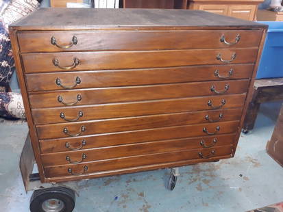
Sold2020Antique Map Architect Blue Print Sea Captain Chest 9 drAntique Map Architect Blue Print Sea Captain Chest 9 drawers custom made flat file cabinet for sea captain architect or blue prints,Maps, 9 drawers all on roller glides drawers work great very good coSee Sold Price
Sold2020Antique Map Architect Blue Print Sea Captain Chest 9 drcustom made flat file cabinet for sea captain architect or blue prints,Maps, 9 drawers all on roller glides drawers work great very good condition see all pics 34 1/2" tall x 41 1/2" wide x 28" deeploSee Sold Price
Sold2016Danckerts (Justus) - Accuratissima et Maxima Totiusextensive map covering south east Europe, the Black Sea and Caspian Sea, southern Tartary, Persia, the Arabian Peninsula and Egypt, title vignette with Turkish imperial costume figures, lion and leopaSee Sold Price
Sold20231748 George Anson World Voyage 3 HUGE MAPS Spain South America Sea Navigation1748 George Anson World Voyage 3 HUGE MAPS Spain South America Sea Navigation George Anson was an 18th-century British Navy admiral who is noted for his important world voyage in which he circumnavigaSee Sold Price
Sold2023Turner, Richard 1814 Miniature Map. The World Hemispheres"The World Agreeable to the last Discoveries in the South Seas &c" Copper Engraved Miniature Map Published 1814, London for "An Easy Introduction to the Arts and Sciences" by Richard Turner. Paper SizSee Sold Price
Sold2023Turner, Richard 1814 Miniature Map. The World Hemispheres"The World Agreeable to the last Discoveries in the South Seas &c" Copper Engraved Miniature Map Published 1814, London for "An Easy Introduction to the Arts and Sciences" by Richard Turner. Paper SizSee Sold Price
Sold2022Africa.- Ortelius (Abraham) Africae Tabula Nova, engraved map, [c.1570-1612].Africa.- Ortelius (Abraham) Africae Tabula Nova, detailed map of Africa based upon Gastaldi's 8 sheet wall map and Mercator's world map of 1569, decorated with a strapwork title cartouche, a sea battlSee Sold Price
Sold2017World on Mercator's Projection 1841 MapWorld on Mercator's Projection' Hall Singapore Town/Island Inset 1841 Map. Title/content of Map: 'the World of Mercator's Projection.' the Map Includes Large Insets Of, from Bottom Left, 1) a Sea CharSee Sold Price
Sold2022Antique Map Print - Map of Pomerania - Map of Germany - South of the Baltic SeaAntique outline hand colored map from edition of Meyer’s world atlas, edited by Ludwig Ravenstein, published by Bibliographic Institute in 1872. Technique: Engraving. Place: Leipzig, Germany. SSee Sold Price
Sold2022Original Antique Map -Pommern Provinz - Map of Bornholm Island Baltic SeaAntique outline hand colored map from edition of Meyer’s world atlas, edited by Ludwig Ravenstein, published by Bibliographic Institute in 1872. Technique: Engraving. Place: Leipzig, Germany. SSee Sold Price
Sold2023Turner, Richard 1814 Miniature Map. Europe"The World Agreeable to the last Discoveries in the South Seas &c" Copper Engraved Miniature Map Published 1814, London for "An Easy Introduction to the Arts and Sciences" by Richard Turner. Paper SizSee Sold Price
Sold20211825 1ed Traveler Mexico Guatemala History Revolution1825 1st ed Traveler Mexico Guatemala History Revolutionary War Illustrated MAP Josiah Conder's “The Modern Traveller” is a remarkable 33 volume undertaking, covering much of the known world. ThisSee Sold Price
Sold20201814 Arabia, Egypt, Abyssinia, Red Sea &c.This is a striking map of Arabia, Abyssinia, the Red Sea and surrounding regions with original color including shaded borders of regions, and mountain ranges marked with hachures. The sandy deserts ofSee Sold Price
Sold2023MAP, Britain, KeulenBritain. Johannes van Keulen, Paskaart van't Canaal Engelandt Schotlandt en Yrland..., from Zee-Fakkel, 1698 (circa). Hand Color. This is the second of Johannes van Keulen's sea charts of the BritishSee Sold Price
Sold2019MAP - Balkans & Italy. Mercator/HondiusNorthwestern Balkans & Northeastern Italy. Mercator/Hondius, Forum Iulium, Karstia. Carniola, Histria Etc., 1610 (published). Hand Color. Charming small map of the northern tip of the Adriatic Sea andSee Sold Price
Sold2019MAP - Ukraine. MercatorUkraine. Mercator/Hondius, Taurica Chersonesus, 1613 (published). Hand Color. Lovely miniature map of the region north of the Black Sea encompassing the Crimea and the southern steppes of Ukraine. TheSee Sold Price
Sold2016Caribbean Island Map, by Mount & Page, 1720 (rare &Spectacular sea chart of the Spanish Main to Puerto Rico, from Mount & Page's English Pilot, Fourth Book. Known as the most important English Atlas of Sea Chart covering the Mediterranean and North AmSee Sold Price
Sold20241757 George Shelvocke "A Voyage Around the World by the Way of the Great South Sea"2nd revised edition Performed in a private expedition during the war, which broke out with spain in the year 1718 with 2 maps and illustrationSee Sold Price
Sold2022Times Atlas 1895 Mixed Lot of 18 Antique MapsIncl Religions of the World, Belgium/Luxemburg, Asia Minor/Persia, Caucasus, Greece, Mediterranean Sea Eastern, Mediterranean Sea Western, Italy North, Sicily/Sardinia, Bohemia/Moravia, Southern ScandSee Sold Price
Jun 07Freeman's | Hindman[MAP]. ORTELIUS, Abraham. Americae Sive Novi Orbis, Nova Descriptio. 1573.US$1,000(1 bid)
Jun 08Leon GalleryRobert Dudley (1573 - 1649) - Carta particolare del'Isola Mindano parte Australe con Celebes e₱500,000
1 day LeftJasper521683 Sanson Map of the Caribbean -- Les Isles Antilles, &c Entre Lesquelles sont les Lucayes, et lesUS$170
Featured1 day LeftJasper521699 Moll World Map with Cowley's Voyages -- Nouvelle Carte du Monde Suivant l'idee de Mercator ouUS$240
Jun 09Worthington Galleries19th c. Hemisphere World Map, Hohen und Tiefen der Erde in Lambert’s Zenithal-Projection vonUS$10
Jun 09Worthington Galleries18th c. Map OBSERVATIONS SUR LES POINTS CARDINAUX. LIGNES, ET CIRCLES DE LA SPHÈUS$10
1 day LeftJasper521771 ASTRONOMY by Joseph M. de La Lande 2 VOLUMES ILLUSTRATED antique in FRENCHUS$480


![Africa.- Ortelius (Abraham) Africae Tabula Nova, engraved map, [c.1570-1612].: Africa.- Ortelius (Abraham) Africae Tabula Nova, detailed map of Africa based upon Gastaldi's 8 sheet wall map and Mercator's world map of 1569, decorated with a strapwork title cartouche, a sea battl](https://p1.liveauctioneers.com/5458/269991/141255679_1_x.jpg?height=310&quality=70&version=1669303305)


![[MAP]. ORTELIUS, Abraham. Americae Sive Novi Orbis, Nova Descriptio. 1573. (1 of 2)](https://p1.liveauctioneers.com/197/329395/177650534_1_x.jpg?height=282&quality=70&version=1715364962)
![[MAP]. SPEED, John. A New Mappe of the Romane Empire. 1676. (1 of 2)](https://p1.liveauctioneers.com/197/329395/177650541_1_x.jpg?height=282&quality=70&version=1715364962)


