Sold2017WIT, Frederick de (1630-1706). [Composite Atlas].WIT, Frederick de (1630-1706). [Composite Atlas]. Amsterdam: F. de Wit, [n.d. ma circa 1680]. Bellissimo atlante composito con oltre 117 mappe di cui la maggior parte a doppia pagina e colorate all'epSee Sold Price
Sold2021Map of NY City from very scarce Colton atlasTitle: Map of NY City from very scarce Colton atlas Date: Map dated 1886 Description: Interesting map of NYC and vicinity, oriented with North at the top (most other double page maps of New York fromSee Sold Price
Sold20232-map set of N. and S. Italy from 1st ed. of Colton atlasNorthern Italy and Southern Italy along with Corsica, Sardinia and Sicily offered as a 2-map set. “Northern Italy: Lombardy & Venice, Sardinia, Tuscany, Parma, Modena, Lucca and the States of thSee Sold Price
Sold20211838 Thomas Bradford Atlas Map of MichiganAtlas map of Michigan showing then current counties, towns, etc. Hand colored borders. Along the bottom margin: “Entered according to Act of Congress in the year 1838 by T.G. Bradford in the ClerksSee Sold Price
Sold2023Seutter - Map of North America including Great Lakes, Florida, Virginia, New England, Mexico, WestThis engraving is from a composite atlas presented by the Homann Heirs. Many of the maps in the collection were completed by J. B. Homann, Homann Erben, M. Seutter, and T. C. Lotter. The maps were oriSee Sold Price
Sold2015George W. Colton. Colton's Atlas of the World, IGeorge W. Colton. Colton's Atlas of the World, Illustrating Physical and PoliticalSee Sold Price
Sold2018Colton’s Atlas of the World.[Maps] Colton, George Wollworth. Colton’s Atlas of the World. New York: J.H. Colton and Co., 1856. Vol. 2 of a two volume set. Publisher’s brown cloth, gilt and blind stamped with black moSee Sold Price
Sold2023Duval - Map of England or Great BritainThis fascinating map is from Pierre Duval. It was part of a composite or collector's atlas of his maps. It was done in Paris circa 1670s. The composite atlas originally included maps from the followinSee Sold Price
Sold20171855 1st Ed. Texas map from Colton’s Atlas of the WorldItem: 1855 1st Ed. Texas map from Colton’s Atlas of the World Description: Counties current to 1854 making this the uncommon and desirable first edition (Tarrant county appears, but not the 1855 addSee Sold Price
Sold2021Colton’s Map of the World - 1855Nice example of Colton's Map of the World from the first edition of Colton’s Atlas of the World. Shows the routes of numerous 18th and 19th Century explorers, including Cook, Furneaux, Vancouver, thSee Sold Price
Sold2019Scarce Colton 1855 map of Texas, Johnson/BrowningScarce large map of Texas with 1855 date, but with Johnson & Browning imprint. The Johnson & Browning imprint was found in only the 1859 Colton atlas and 1860 and 1861 Johnson Family atlases. This mapSee Sold Price
Sold2017J. H. Colton: Map of United States of America, 1855The United States of America. J. H. Colton, 1855. 15.75 x 26. From the 1856 second edition of Colton’s Atlas of the World. Clean with very minor edge toning. Couple of tiny margin spots. One extremeSee Sold Price
Sold2023Duval - Map of Mexico & New Spain or Central AmericaThis fascinating map is from Pierre Duval. It was part of a composite or collector's atlas of his maps. It was done in Paris circa 1670s. The composite atlas originally included maps from the followinSee Sold Price
Sold2021Palestine from Colton 1st ed. atlasExcellent and clean example of Colton’s map of Palestine, from the first edition of Colton’s Atlas of the World. Includes modern day nations of Israel, Palestine and Lebanon with parts of Syria anSee Sold Price
Sold2023Duval - Map of Southeast Europe (Hungary, Transylvania, Bulgaria, Bosnia)This fascinating map is from Pierre Duval. It was part of a composite or collector's atlas of his maps. It was done in Paris circa 1670s. The composite atlas originally included maps from the followinSee Sold Price
Sold2023Duval - Map of IcelandThis fascinating map is from Pierre Duval. It was part of a composite or collector's atlas of his maps. It was done in Paris circa 1670s. The composite atlas originally included maps from the followinSee Sold Price
Sold2022Scarce 1st ed. Colton RR map of North CarolinaLovely example of North Carolina map from the first edition of Colton’s Atlas of the World. One of the few mid-19th century maps to show North Carolina independently—it was more often mappSee Sold Price
Sold2022Impressive vintage Colton map of MaineReally nice original vintage map from the very uncommon 1857 Colton General Atlas. (See description of 1857 Colton atlas in item 215-22). Shows highly detailed representation of the coastal features oSee Sold Price
Sold2021Rare 19th Century Map of The Environs of ParisRare 19th Century Map of The Environs of Paris. Published in 1856 by J. H. Colton & Co. New York. Colton atlases, especially those from the 1850's, have become increasingly rare. The Colton maps wereSee Sold Price
Sold2022[MAPS & ATLASES]. COLTON, J.H. (1800-1893). Colton's New Topographical Map of The States Of[MAPS & ATLASES]. COLTON, J.H. (1800-1893). Colton's New Topographical Map of The States Of Virginia, Maryland and Delaware, Showing Also Eastern Tennessee & Parts Of Other Adjoining States. New York:See Sold Price
Sold2023[MAPS & ATLASES]. COLTON, Joseph Hutchins. Colton's Map of the United States of America, the[MAPS & ATLASES]. COLTON, Joseph Hutchins (1800-1893). Colton's Map of the United States of America, the British Provinces, Mexico and the West Indies. Showing the Country from the Atlantic to theSee Sold Price
Sold20231874 Colton's General AtlasNew York,1874 "Colton's General Atlas with Descriptions" with maps drawn by G. Woolworth Colton, descriptions by Richard Swainson Fisher, published by G.W. & C. B. Colton & Co. in 1874. Print on paperSee Sold Price
Sold2019Colton's General Atlas, 1874Heading: Author: Colton, G. Woolworth Title: Colton's General Atlas, Containing One Hundred and Eighty Steel Plate Maps and Plans, one One Hundred and Nineteen Imperial Folio Sheets, Drawn by G. WoolSee Sold Price
Sold2018COLTON, George Woolworth (1827-1901). Colton's GeneralCOLTON, George Woolworth (1827-1901). Colton's General Atlas. New York: J. H. Colton and Company, 1857. 4to (432 x 360 mm). Steel engraved frontispiece, 95 (of 96) steel engraved maps (6 double-page),See Sold Price
Jun 07Freeman's | Hindman[MAPS]. HOMANN, Johann Baptist, HOMANN HEIRS, and Georg Matthäus SEUTTER. [Composite Atlas].US$15,000
May 30Forum Auctionsd'Anville (Jean Baptiste Bourguignon) [Untitled Composite Atlas with 102 map sheets], [probably£2,000
5 hrs LeftJasper52countries of the Ancient World exhibiting the probable settlement of the descendants of NoahUS$45
1 day LeftPacific Global AuctionNew York Islanders Game Used Puck 12/9/21 vs Nashville Goal #6 Puck Scored by Yakov TreninUS$110
Jun 02Tremont AuctionsEdmund Howard, English ebonized bracket clock with composite brass dial, Chelsea, circa 1760. TwoUS$300(1 bid)
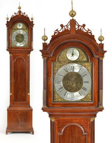
Jun 02Tremont AuctionsSamuel Mulliken mahogany tall case clock with composite brass dial, circa 1790. The Chippendale caseUS$1,200
May 30Cedarburg Auction & Appraisals LLCRare Appleton Valley WI Salt Glaze 4 Gallon Crock 1860s Attributed to Leonard Roher PotteryUS$90(3 bids)
15 hrs LeftHannam's Auctioneers LtdA SMALLER UNUSUAL 19TH CENTURY INDUSTRIAL BRONZE LANTERN FORM CLOCK of almost architectural form, wi£60
15 hrs LeftHannam's Auctioneers LtdA FINE 19TH CENTURY JAPANESE CARVED BOXWOOD NETSUKE OF A SEATED MALE wonderfully carved squatting wi£180
15 hrs LeftHannam's Auctioneers LtdThe Complete Atlas of Modern, Classical and Celestial Maps, together with Plans of the Principal Cit£240
May 29Cedarburg Auction & Appraisals LLCDress blues ,Felt Fire Department Hat Made by Kohler Caps of Milwaukee WIUS$25(1 bid)


![WIT, Frederick de (1630-1706). [Composite Atlas].: WIT, Frederick de (1630-1706). [Composite Atlas]. Amsterdam: F. de Wit, [n.d. ma circa 1680]. Bellissimo atlante composito con oltre 117 mappe di cui la maggior parte a doppia pagina e colorate all'ep](https://p1.liveauctioneers.com/3662/102842/52581030_1_x.jpg?height=310&quality=70&version=1492593376)


![Colton’s Atlas of the World.: [Maps] Colton, George Wollworth. Colton’s Atlas of the World. New York: J.H. Colton and Co., 1856. Vol. 2 of a two volume set. Publisher’s brown cloth, gilt and blind stamped with black mo](https://p1.liveauctioneers.com/928/124137/63148812_1_x.jpg?height=310&quality=70&version=1530051387)


![[MAPS & ATLASES]. COLTON, J.H. (1800-1893). Colton's New Topographical Map of The States Of: [MAPS & ATLASES]. COLTON, J.H. (1800-1893). Colton's New Topographical Map of The States Of Virginia, Maryland and Delaware, Showing Also Eastern Tennessee & Parts Of Other Adjoining States. New York:](https://p1.liveauctioneers.com/197/265299/138516337_1_x.jpg?height=310&quality=70&version=1666051328)
![[MAPS & ATLASES]. COLTON, Joseph Hutchins. Colton's Map of the United States of America, the: [MAPS & ATLASES]. COLTON, Joseph Hutchins (1800-1893). Colton's Map of the United States of America, the British Provinces, Mexico and the West Indies. Showing the Country from the Atlantic to the](https://p1.liveauctioneers.com/197/305583/163286506_1_x.jpg?height=310&quality=70&version=1697143109)


![[MAPS]. HOMANN, Johann Baptist, HOMANN HEIRS, and Georg Matthäus SEUTTER. [Composite Atlas]. (1 of 5)](https://p1.liveauctioneers.com/197/329395/177650530_1_x.jpg?height=282&quality=70&version=1715364962)
![d'Anville (Jean Baptiste Bourguignon) [Untitled Composite Atlas with 102 map sheets], [probably (1 of 3)](https://p1.liveauctioneers.com/5458/329231/177514974_1_x.jpg?height=282&quality=70&version=1715269091)